
-
 10086 Hits
-
 78.27% Score
-
 9 Votes
|
|
Route |
|---|---|
|
|
34.34333°N / 117.82939°W |
|
|
Download GPX » View Route on Map |
|
|
Hiking |
|
|
Spring |
|
|
Half a day |
|
|
Trail, some sketchy spots |
|
|
Overview
Windy Gap (~7,580’) is the prominent low-point along the ridge that connects Mount Islip with the Mount Hawkins Ridge in the Crystal Lake Recreation Area of the San Gabriel Mountains in Southern California. Windy Gap can be viewed as a hub, at which many trails intersect. From the Gap, trails lead south to the Crystal Lake Recreation Area, northwest to Mount Islip, north to Little Jimmy Trail Camp and further to the Angeles Crest Highway, and southeast to the Hawkins Ridge. It also marks a watershed in the San Gabriel Mountains as the water south of the Gap eventually forms and the San Gabriel River and empties ultimately into the Pacific Ocean, while the water north of Windy Gap is desert-bound. There are several ways to reach Windy Gap. For many years the trail from the south, from the Crystal Lake Recreation Area, was not open to the public as the entire area was closed following the devastating Curve Fire of 2002 and several major setbacks from torrential rainfalls in subsequent years. With the recent (April 2011) re-opening of the Highway 39 to the Crystal Lake Recreation Area, the approach of Windy Gap from the south via the Windy Gap Trail will undoubtedly again become a favorite among hiking enthusiasts. The following route description illustrates the Windy Gap Trail from the Crystal Lake Recreation Area to Windy Gap.
The hike from the Crystal Lake Campground to Windy Gap is about 5 miles round-trip with roughly 1,800 feet of elevation gain. Although generally well-restored and easy to follow, some spots are sketchy and require careful footing, especially on the rocky traverse below the Hawkins Ridge.

|
|---|
Getting There
From the 210 Freeway in Azusa drive on Azusa Avenue (SR39) north through Azusa and further into the San Gabriel Canyon. After passing the Morris and San Gabriel Reservoir you will come to a junction with the East Fork Road at 12 miles (from the freeway). Continue straight for another 12 miles driving up-canyon into the North Fork San Gabriel River. You will gain quite a lot of elevation on this curvy and steep road. Turn right at the sign to Crystal Lake Recreational Area and drive on the road towards the campground. As of this writing (June 2011) the campground is still closed and you have to park your vehicle near the snack shop and small visitor center. Walk on one of the campground roads north and east for about 0.5 miles to reach the Windy Gap Trailhead.
Route Description
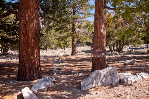
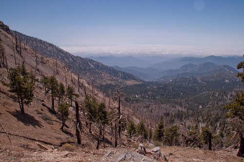
From the trailhead (5,840’) hike north along the shady rock-lined path through a beautiful open forest of pines, cedars, and firs. You will cross a campground road (about 0.25 miles from the trailhead). Continue north on the trail until you intersect a fire road at 0.5 miles (from the trailhead) leading to Deer Flats (west, left) and South Mount Hawkins (east, right). The trail continues on the opposite side of the road and turns right (east) soon after. The Big Cienega Trail veers off to the left (west) climbing to the Islip Ridge in about 1.8 miles. Continue uphill on the trail you now cross several small gullies and ravines. Sometimes, fallen tree logs block the path and you will have to climb over or crawl beneath them to continue. After about 1.2 miles from the trailhead the trail turns north and west and starts its steady uphill climb traversing the steep south side of the Hawkins Ridge. Here you will see the devastation caused by the 2002 Curve Fire to its full extent with numerous dead, scorched tree stumps dotting the slopes.
| Windy Gap Trailhead | Remains of the Curve Fire |
|---|---|
 |
 |
The trail-builders did a marvelous job restoring the trail to its current shape again. Several spots during the traverse have been re-enforced. However, the fragile character of the trail is easily seen at several spots were rockfall or landslides from the steep south slope of the Hawkins Ridge swept over the trail. Most of these spots can be traversed easily with some care. One spot, however, where rockfall created a steep and loose section of the trail about 10 feet wide requires extra care. After that, the trail climbs towards Windy Gap moderately steep in large switchbacks. After a little less than 2.5 miles from the trailhead you reach Windy Gap (~7,580’).
| Rockslide | Windy Gap |
|---|---|
 |
 |
You can relax here and enjoy the beautiful views south over the Crystal Lake Area, North Fork of the San Gabriel River and surrounding peaks. Mount Islip rises to the west and the ridge connecting to Mount Hawkins is to the east. If you look closely, a portion of the Angeles Crest Highway can be seen through the trees directly to the north. Several route options invite to extend your hike from the Gap. Straight ahead along the PCT to the north is Little Jimmy Spring and Little Jimmy Trailcamp (0.3 miles). The PCT continues from Windy Gap to the east towards the Hawkins Ridge trail junction (1.4 miles). The trail to Mount Islip is directly to the left (west, 1 mile). You can climb Mount Islip, descend from its summit via the Islip Ridge south, and follow the Big Cienega Trail from the Islip Ridge back to Windy Gap Trail, for a nice lollipop hike. Contemplate your options or return the way you came.
| Crystal Lake Area | Windy Gap |
|---|---|
 |
 |
Red Tape
The upper portions of the trail are in full sun, so carry plenty of water and sun protection as needed. Don’t forget to display your Adventure Pass on your parked vehicle.
External Links
Photos of 2002 Curve Fire