The Stars Align...
I love winters in the Southern Appalachians. The haze of summer is gone, bare tree limbs allow for more views, comfortable temps in the 40's and 50's, and the odd belief among most locals that it's "too cold" to hike make for beautiful and quiet trails. Being a northern boy I do miss the snow though. Each year between November and April I would find myself wishing for a good snowstorm so I could dust off the winter gear and enjoy a day in the snow on some high peak. The elusive southern snows have come and gone over the last few years but I've never been able to catch a "day after the storm" to go out and enjoy it. Between work and two small children it’s hard to be choosy about days to go out and hike. All that changed on January 9th.
It wasn't exactly the "storm of the century." Around 6 inches or so of nice fluffy snow coated the High Country on the 9th. In a winter where 60 degree readings have been more common than snowflakes it was a nice switch to normal. What was even better was that both my wife and I had the next day off!!! It was a miracle! The only problem was that our family was only a week away from a big move back to Michigan and the 10th was to be a major packing day due to our coinciding day off. Luckily I have one of the most understanding and sensitive wives on the planet. She understood how catastrophic it would be to her husband’s mental and emotional well-being to miss this opportunity to go get out in the snow. I got the OK to go out and play.
I knew just where I was headed...
The Profile Trail...
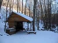
![Trailhead Hut]() The Trailhead Shelter
The Trailhead Shelter
The 10th dawned with the cold and clarity that only comes after a storm. I could see a few clouds hanging around the upper slopes of Grandfather but was willing to chance that they would burn off in the sunshine. I loaded up the old Subaru and headed out to climb Grandfather by the only route you can after a snowstorm, the Profile Trail.
The Profile Trail starts from a small parking area about a half-mile south of where Highways 105 & 184 meet near Banner Elk. The parking area sits about 25 feet off the east side of the highway....straight down. It probably wasn't the smartest idea but I banked on the Subaru's ability to claw its way back out later and parked down at the lot. I really wouldn't recommend this option though. Better to just park across the highway and walk the extra 100 yards. If your car gets stuck down there you're just going to have to wait for a thaw.
The Profile Trail begins at the far side of a
small shelter that, during warmer days, is manned by a local college student checking that every one has a pass to climb the mountain. Not surprisingly there was no-one around this 15-degree morning to check mine. For the first half mile or so the trail follows the banks of the Watauga River. There are no bridges along the Profile Trail but a few crossings do have
well-placed logs to aid you. The snow was beautiful. I realized quickly that I was going to make really crappy time on the ascent. There were too many things to take pictures of. The first mile and a half was fairly
easy going. The trail makes its way across
Shanty Spring Branch for the first time of many along with a few other unnamed streams. There wasn’t much along this first section of trail to mark my progress except for the odd little
mile posts that are unique to Grandfather Mountain. About half way up the ridge the trail passes a nice little rest stop called
Foscoe View. A comfy log bench invited me to stop and take in the view, so I obliged. The view from here to the north was amazing. I couldn’t wait to see it from up top. After a short break I holstered up the pack and continued the climb.
![Foscoe View]() Foscoe View
Foscoe View
Above Foscoe View the trail gets progressively rocky but I don’t recall it ever being difficult. It was chilly though. As I passed below the Profile cliffs the sun disappeared behind the ridge and the forest became noticeably
colder. It was around this time I realized the water had frozen in the tube of my Camelback. I had carelessly forgotten to tuck it into my coat back at my last stop. I tucked it back in hoping it would thaw. Before long I arrived at
Profile Campsite and to no great surprise it was unoccupied. Even with the surrounding woods the campsite didn’t look like a real sheltered place to spend the night. Wind-sculpted drifts of snow attested to that fact. Looking up through the trees I could see the Profile cliffs but other than that there wasn’t much to look at. With no water to drink, I continued on. About three-tenths of a mile later I arrived at
Profile View. A well placed cut in the trees affords views of Grandfather Mountain’s original attraction. According to a nearby sign the profile you can see from here is actually the profile the mountain became famous for, not the one you can see from Hwy. 105 in Foscoe. The Profile has faded into obscurity, however, I imagine mainly due to the fact that you can’t drive your Cadillac SUV up to this one…
![Profile View]() Profile View
Profile View
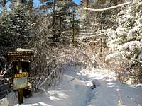
Above Profile View the trail became noticeably more rocky and slick. I had read and heard that the
trail near Shanty Spring could become and ice gully and they weren’t kidding. I’m sure it could have been worse but the combination of ice-covered rocks concealed in a thin layer of snow slowed me down and made for some careful stepping. The woods above 5000’ were
amazing. Every tree branch and rhododendron leaf was covered in a coating of ice and snow. I spent a rather ridiculous amount of time constantly breaking out the camera because each
ice-coated pine looked prettier than the last. After nearly landing on my ass a few more times I made it up to Shanty Spring. This is the
last reliable water on the trail as a nearby sign is clear to point out. There was also a really
cool cliff covered in enormous icicles rising above the spring. It was neat to look at but at the same time I knew I eventually had to climb above the cliff and all that ice had to be coming from somewhere…best to keep watching where I step.
![This Way to the Spring...]() Nearing Shanty Spring
Nearing Shanty Spring![Calloway Gap - 5642]() Calloway Gap
Calloway Gap
Above Shanty Spring Grandfather Mountain starts acting more like itself. It’s only about a quarter mile from the spring to the ridge but the combination of ice and rock made it seem much longer. You don’t come to Grandfather for nice flat wood-chipped trails though do you… The snowy forest continued to take my breath away. As I climbed higher the sun topped the ridge and bathed the treetops in a sparkling golden glow. It may make me sound weird but it was, for lack of a better term,
magical. I made my way up into the sunlight and soon arrived at
Calloway Gap. I was a bit surprised at how sheltered the gap was. I expected to gain the ridge and have some wind to deal with. There wasn’t even a breeze. The snow had set a bit deeper in this sheltered col, about 8 or 10 inches, and the sun felt warm even though it couldn’t have been above 10 degrees. I took the opportunity to move my Camelback from my pack to under my coat to help get the water flowing. My fingers were getting increasingly cold and I was pretty sure the lack of water wasn’t helping. After suiting up I turned left up the Grandfather Trail.
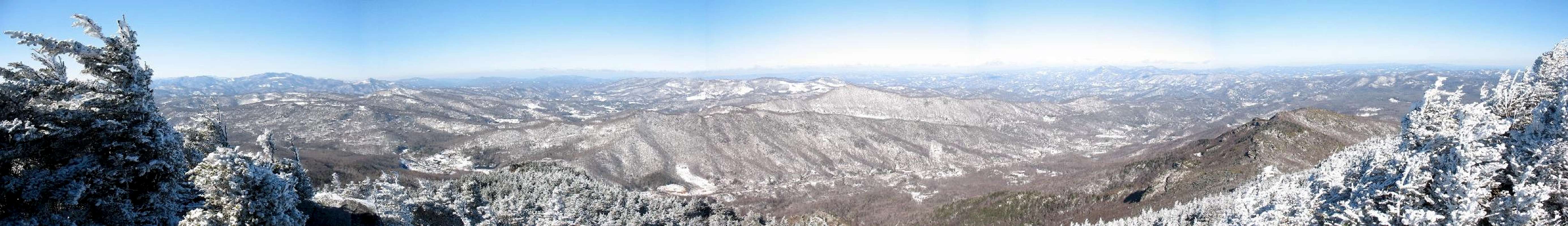
![Summit Ridge Pano]() The Panorama from the Summit Ridge
The Panorama from the Summit Ridge
Being thirsty in cold weather sucks, almost as much as if it were 100 degrees, but in a completely different way. I was enjoying being up on the ridge and the
views that were beginning to open up but after climbing over 1000 vertical feet with no water I was ready to be at the top. I reached the
Watauga View Spur about 0.1 miles below the summit but decided to get to the top first then hit the view on the way down. Climbing the first ladder up onto the exposed rock of the summit ridge the wind hit me. Whoo, was it
chilly. My guess it that it was blowing at about 20mph, enough to give a wind chill of 5 to 10 below. My fingers were hurting but I didn’t mind, this was the kind of weather I came up here for! The panoramic
view to the north was amazing. I had been up here many times before but with the rime on the trees and the snow-covered landscape it was like I was seeing it for the first time. I made my way carefully up and over the last couple ladders and arrived at the
summit “x.”
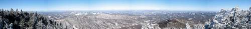
![Calloway Summit Pano]() Calloway Summit Pano
Calloway Summit Pano
The
panorama from the summit of Calloway is incredible. To the east the landscape drops almost a vertical mile to the rolling hills of the Piedmont.
To the south the view included neighboring Attic Window Peak and stretched all the way to the Black Mountains. The summit was fairly protected as the wind was blowing from the north into the
scrub behind me. I didn’t stay long though. I wolfed down some crackers, a couple frozen M&M’s, and drank some blessed thawed water, then headed down. I figured I’d spend a little time over at Watauga View also. I made the quick drop down to the spur trail and made my way through a particularly snowy bit of woods out to
Watauga View. Holy crap! I thought the wind was bad on the ridge. Watauga View faced it directly. Taking shots of the view literally took my breath away. 2500’ below was the little town of Foscoe and off to the north were the various snowy peaks of the Amphibolite Range. To the west and south were the
abused slopes of Sugar and Beech Mountains surrounding my hometown of Banner Elk. It was beautiful but it always amazes me to see how man can so selfishly destroy such beauty. It makes me appreciate that, even though I have to buy a pass to climb Grandfather, at least the people I’m paying are using it to conserve rather than destroy.
![Rime]() Rime
Rime![Hidden Danger...]() Slick Descent
Slick Descent
After getting the shots I wanted I dove back
into the woods for cover. I wasn’t looking forward to having to negotiate the icy trail around Shanty Spring again. Ice on rocks going uphill is annoying. Ice on rocks going downhill can hurt. Frequently I just decided to avoid the trail altogether, especially when it looked
like this. I made it down past the spring with remarkably little trouble and just before reaching Profile View again I crossed paths with the only other hiker I met on the trail that day. The trip down from Profile view was a breeze. I figured I had spent enough time on the way up taking pics so I kept the camera holstered most of the way down. Before I knew it I was back down along the banks of the
Watauga River. The only thing on my mind at this point was the climb out from the parking lot. I was looking forward to that hot plate of Spaghetti I had been promised when I got home (didn’t I tell you she was a great wife?!). Lucky for me the car made the climb back up to the highway with no problems (Subaru’s rock!) and was soon back in that line of traffic headed for Banner Elk.
I couldn’t have asked for a nicer day to go. Except for that lone hiker on my way down I was alone for the entire trip. The views were incredibly clear and the snow was just deep enough to enjoy without making the climb any more work. I am so happy that I was able to get a true winter hike in before leaving the mountains. I probably won’t be back out on the trail in these parts for a while so I’m glad my last hike here was so special.
As always, a wonderful day in the mountains!
![Watauga River]() The Watauga River
The Watauga RiverThe Nuts & Bolts...
Trailhead: Profile Trail Parking Area on Hwy. 105 about a half mile north of Grandfather Center (Lowes Foods, Eckerd Pharmacy).
Trailhead Coordinates: 36.1208°N, 81.8324°W
Trailhead Elevation: ~3900'
Summit Elevation: 5964'
Total Elevation Gain/Loss: ~2064'
Trail Length/Info: Total is 3.4 miles from the parking area to the summit. It took me the better part of 3 hours to climb with stops for pictures. The descent took about 2 hours. As stated in the report the mile or so section of trail above and below Shanty Spring is
very icy. If this had been a normal winter I'm sure crampons would be a necessity. As it was when I went, however, there was still enough exposed rock that I think crampons would have been more a hinderance than a help.
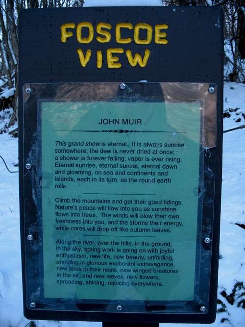
![Why we Hike...by John Muir]() Why We Hike
Why We Hike


Comments
Post a Comment