
|
|
Route |
|---|---|
|
|
42.49550°N / 111.2482°W |
|
|
Hiking |
|
|
Spring, Summer, Fall |
|
|
Half a day |
|
|
Overview
There are several ways up this mountain but this cross country route is the shortest and fastest way to go. After the snow melts, this is a class two hike (if you pick the right line via the saddle) and requires no technical skill, just desire since it is relentlessly upward, gaining 2400 feet in about a mile and a third.
Getting There
See Meade Peak page for this information.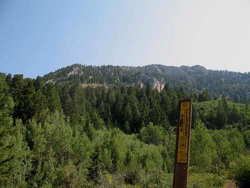
Route Description
After leaving the parking area, you will immediately see a Forest service marker noting that the ATV road is closed. Walk up the ATV road (which becomes a trail)about three tenths of a mile and at a point where it crests a small rise and starts to drop down, pick an uphill line and go for the saddle, staying away from the rocky outcrops on both sides. Even though it is very steep, it is never difficult and game and cattle trails make it even easier to make your way upward. Initially we stayed in the forest as it ascended a rib but after a while we just moved out onto the slope and headed up. It is all cross country and occasionally you will see a boot print or an indicator that you are not the first to go this way. However, you pick your your own line and that is kind of enjoyable. As you gain the saddle, angle to the north and stay as high as you can as it is not necessary to drop into the basin or lose elevation.As you work your way up toward the summit area (gps makes this easy), take time to enjoy your surroundings. There is nothing difficult about this hike and if it becomes difficult, most likely you have taken the wrong line up. Study the map and the picture that I've included to aid your effort.
The summit is easy to spot as a large cairn with two iron rods mark it. We found two witness bench marks and a register placed by Jobe Wymore. Quite a few signatures attest to the fact that there are many locals who enjoy visiting this summit. Many ride horses into Meade Basin and "run" up from there.
Our totals:
3 miles round trip with 2400+ elevation gain.
2 hours 15 minutes up with 1 1/2 hrs down.
You could drive the road, get the peak and return out on the same day.
Essential Gear
Plenty of water as this is a dry hike after the middle of July. Let common sense be your guide.