

Comments
No comments posted yet.
|
|
Album |
|---|---|
|
|
Hiking |
 Sempervivum montanum The main reason why I have created this page was that I accidentally learnt that the owner of the "mtn/rock pages" for these peaks had never set foot on the slopes of these mountains. Now things have changed, and that's OK. Talking of my pix here, they are scanned prints from our summer holidays in 2004-2005. Unfortunately, at the beginning of the 21st century I decided to switch from transparencies to negative film as well as replacing my good old Russian Zenit-E (made in the late 1970's) with a little compact Minolta. (The green rug in the top left-hand corner is a scanned transparency - picture taken with the old camera in 2002). |
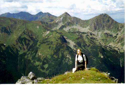
| Baníkov aka Banówka 2,178m One of the two most attractive summits in the Western Tatras, in their western part which Slovak people call the Roháče, Banówka is the highest summit in the main ridge of the Western Tatras. (Its name probably derives from the Hungarian/Slovak word for "a mine/miner".) Its main attraction and the actual reason that I tried to climb it in 2002 (failed after being caught in thunderstorm 1.5km east of the summit, then climbed it with Hanna the following year) is several hundred metres of the narrow crest, part of the main ridge of the Western Tatras, running east of the main summit. No, we are not talking of the Alps. But it is fairly airy and in wet or wintry weather conditions a climb can be pretty dangerous (I bet the average SP'er does not have to be told this). Such a piece of jagged granite ridge is a rarity in this quarter of the Tatras (even as far as the High Tatras are concerned such a thing is a rarity in terms of what is legally available, that is to say on the net of the marked trails within the National Park). The uppermost section of the mighty side ridge of Ráztoka/Rozsocha (green stripes leading to Žiarska chata, i.e. hut) between Baníkov and Jalovecký Príslop 2,142m which runs from Banikov to the south is also quite narrow although its west flank is just a steep slope, not a sheer drop like quite a bit of its east flank. 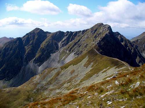 The east face of Jalovecký Príslop (2,142m) on the left,and Baníkov (2,178m) on the right (photo by horrste). The east face of Jalovecký Príslop (2,142m) on the left,and Baníkov (2,178m) on the right (photo by horrste).The western face of Baníkov, down which the ridge trail continues towards the westernmost reaches of the Tatras, is the gentle side of the mountain. A descent to Baníkovské sedlo (Baníkov Saddle) at 2,040m takes just over 20 minutes. |
For Slovak people, the Roháče is the name for the part of the Tatras' main ridge extending a little east of Ostrý Roháč and far west of Baníkov. But Polish people tend to think there are only two Rohacze: Ostry and Płaczliwy (Slovak: Ostrý Roháč and Plačlivé, which translates as Sharp and Weepy). They rise, as the crow flies, about 3km east of Banówka. I bet you guess Ostry Rohacz at 2,088m, despite being lower than Płaczliwy (2,125m) is the sharper one, and you are right.:) Like Banówka, Rohacze are made of granite, which is what makes these summits look so attractive against the gneiss-schist background. The name Roháče/Rohacz seems to derive from the "rohatý/rogaty (horned)", which looks like a reference to the shape of these peaks.
 Rohacze: Ostry (left: the main summit at 2,088m to the right of the Notch)and Płaczliwy at 2,125m (far right) - photo by Barbon). Rohacze: Ostry (left: the main summit at 2,088m to the right of the Notch)and Płaczliwy at 2,125m (far right) - photo by Barbon).For the hiker/scrambler, the tastiest bit is the uppermost part of Ostry Rohacz. It is split in half by a distinct cleft called pretty simply Rohacka Szczerbina (the Notch). This place can be more dangerous than the locally famous Rohacki Koń (Polish: koń = horse; some have straddled it while moving along), the most exposed bit of the marked trail in the Western Tatras. It is located on the other side of the NE summit of Ostry Rohacz (which is just a few metres lower than the main, SW summit). Its southern flank below its very top is very steep but not vertical, the holds are good and firm so in good summer weather conditions an experienced scrambler doesn’t have to touch the chain which secures the passage here. (Nevertheless, if you slip you’ll have no chance of surviving the fall.) This is one of the few places between Rohacze and Banówka where you usually have to wait several minutes till those coming from the other side pass this little tricky arête, just about a dozen metres long. People usually take good care here so I guess more have lost their lives having fallen down from the Notch. There is no chain at the bottom of the Notch, and if you’re in a hurry, proceeding very fast, you may trip or slip easily and be gone forever. |
Fortunately, border crossing is no problem at all any more but the national park rules are quite strict. In Slovakia, you don't pay an entry fee but you're not allowed to roam the park in winter/spring. Here are the detailed regulations for various fun activities.
In Slovakia - unlike in Poland - those who do not carry commercial insurance have to pay for any rescue services rendered by Mountain Rescue Service (HZS). Mountain rescue team's phone number: Slovakia (HZS): 18 300 Poland (TOPR): 601 100 300