
-
 9588 Hits
-
 81.18% Score
-
 13 Votes
|
|
Mountain/Rock |
|---|---|
|
|
47.32605°N / 120.99174°W |
|
|
Kittitas |
|
|
Spring, Summer, Fall, Winter |
|
|
5527 ft / 1685 m |
|
|
Overview
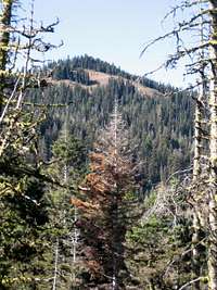 peak-a-boo view from Yellow Hill trail to the south
Yellow Hill is almost always done in conjunction with Elbow Peak, and sometimes with Jolly Mountain as well. Its mostly forest-covered hump is not necessarily a worthy objective on it’s own, but makes a great bonus peak when combined with another. It makes an interesting winter or early season objective as well. Much of the way follows along a ridge top, with great scenery of the surrounding Teanaway peaks, as well as Mt. Rainier to the SE and Mt. Stuart to the NE.
Yellow, Elbow, & Jolly all sit along the same South-North ridge of the Teanaway region of the Cascade mountains. They are not located in a protected area, however, so depending on the day, you might share the trail with hunters, snowmobilers, four-wheelers, or motorcycles. That said, on many days you may be able to summit both peaks without seeing another soul on the trail at all.
Yellow Hill and Elbow Peak became well known by inclusion in Spring & Manning’s classic 100 Hikes in the Alpine Lakes (#58). Their trail description, however, does not include directions to the summit of Yellow Hill.
The Trail
 true summit area and marker
The primary route to Yellow Hill is via the Yellow Hill trailhead #1212. From the first end of the road / parking area (see getting there and away), the trail and road intersect for about 1.5 miles, until even the most intrepid four-by-four must call it quits, along the first significant point of the ridge. From here (in different spots) one can see Mt. Rainier, Mt. Stuart, and limited views of Yellow Hill ahead.
The trail drops and ascends at least twice, heads through some significant old growth trees, climbs, and then flattens out and wanders along the side of the Yellow Hill summit at some 3.25 miles from the starting point. The easiest way to find the summit is to continue to a rocky section before the trail drops significantly (Elbow Peak will be there, first visible, in the distance), and scramble up those rocks and back along the gentle summit area until you reach the high ground. The true summit is a small grassy area ringed by trees with an obscured view of Mt. Stuart. Two USGS markers are there to confirm your find, one driven in the ground like a railway stake and the other crudely cemented to some rocks a few yards from there. Winter visitors, or those in the early season, might have to rely on GPS coordinates to confirm their bearings, or else just walk around until they are sure they have hit that highest spot.
From near the summit of Yellow Hill, the trail descends and climbs again to Elbow Peak (1.75 miles further), and Jolly Mountain(about 3.5 miles further still). With Elbow Peak it would normally be done as a R/T hike, but to Jolly Mountain you would want to have two cars for a one-way trip.
 Yellow Hill and ridge leading to Elbow Peak from the North
Getting There & Away
From I-90, take exit #85, just east of Cle Elum, WA. Head east on 970, and turn left (West) on Teanaway Road. After 7.6 miles turn left on the West Fork Teanaway Road and proceed .7 miles to the Middle Fork Teanaway Road. Follow that past the end of the pavement, about 4.9 miles total, and turn right on “road” 113, trail # 1212. In less than .1 miles arrive at a wide area where dirt has been bulldozed to cover the roadway, and start from there. 4x4s have made their own trail around that to the right, and you could conceivable push on for another half mile to mile farther, even in a two-wheel drive car, if you really insist. But if you do get stuck you may have to walk several miles for help, so don’t say you weren’t warned. pano as viewed from Elbow Peak to the North