
-
 14267 Hits
-
 85.87% Score
-
 21 Votes
|
|
Mountain/Rock |
|---|---|
|
|
38.42630°N / 105.2874°W |
|
|
Fremont |
|
|
Hiking |
|
|
Spring, Fall, Winter |
|
|
6940 ft / 2115 m |
|
|
Overview
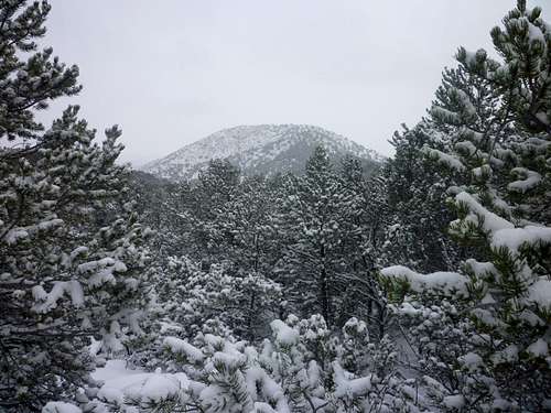 YMCA in the distance from the west
Rising to less than 7,000 gentle feet in elevation in the Grand Canyon Hills of Colorado, YMCA Mountain is no alpine giant. But this cool little peak with a funny name offers neat views of the Royal Gorge (without the crowds!) and expansive views of Cañon City far below. For such a humble little hill, YMCA mountain occupies some pretty fancy real estate on a triangle of land jutting out into the confluence of the Temple Canyon of Grape Creek and the Royal Gorge of the mighty Arkansas River.
High desert plant life enjoyed during a visit to this peak include Cholla, Prickly Pear, Piñon, Gambel Oak and Juniper. This provides a neat change in surroundings from the more run-of-the-mill Colorado alpine experience.
Accessible from the west via 4x4 roads in the dry conditions, the summit of YMCA Mountain is only a short hop from the truck in the summer, but winter or wet conditions provide a more fulfilling day outing when gate closures increase the distance between parking and summit and snows increase the resistance of each footfall.
Colorado Rank: 4128th highest peak in Colorado
Prominence: 840 feet
USGS Quad: Royal Gorge
Trails Illustrated Map: #135 (Pikes Peak, Cañon City)
*Rank and Prominence Reference: Lists of John
Getting There
YMCA Mountain rises at the mouth of the Royal Gorge on the south rim, only three miles as the crow flies from the center of Cañon City, in Fremont County, Colorado. The primary road servicing this area is US Highway 50.
Route Information
The below route can be shortened considerably in dry conditions by making your 4x4 do most of the work for you. Mileage and elevation gain on-foot assumes the gate at Rt 3 / Rt. 341 is locked due to wet conditions and/or that you do not have a 4x4 suitable for the dirt roads.Mileage: Approximately 11.25 miles round trip
Elevation Gain: Approximately 1,650 ft. net gain
This wishbone route takes in both YMCA Mountain and its unranked neighbor, Baldy Mountain (6835 ft.) and leverages dirt roads for easier passage through the brush.
 Note: This map depicts an actual GPS track
Driving Directions: From US 50 west of Cañon City, take Rt. 3 south almost 3 miles to Rt 3A. Take Rt. 3A east for about 1 mile, then turn south on Rt. 341A / Rt. 3. After about 2 miles look for a BLM dirt road / gate on your left. This is your trailhead.
Red Tape
 Summit Cairn and Cañon City
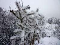 Snow covered cholla
YMCA Mountain resides within Bureau of Land Management (BLM) lands and few restrictions apply. There is no fee to enter the area. Note that gate closures will restrict access to foot traffic in wet conditions.
If accessing the peak from the west via Rt 3 / Rt. 341A,be careful to use the entry way south of Volcano Gulch, avoiding the private roadway to the north.
Camping & Lodging
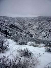 Royal Gorge from the summit
Near the Mountain
There are ample places to pitch a tent on this BLM property, but be prepared to haul your own water in.
Red Canyon Park
According to the Trails Illustrated map of the area, camping is available in this Cañon City park located north of Cañon City via Rt 9 (which becomes Shelf Road).
Shelf Road Recreation Area
The Bureau of Land Management operates two campgrounds in the Shelf Road Recreation Area about 12 miles north of Cañon City. The Bank (13 sites) and Sand Gulch (16 sites) each have tent pads, picnic tables, fire grates and a vault toilet.
Oak Creek
The National Forest Service operates a free, year-round campground about 16 miles south of Cañon City via County Road 143 (Oak Creek Grade Road). There are 16 sites, but no water is available (haul your own).
Weather & Seasons
 Summit ridge
 Approaching the summit
The mountains around Cañon City are typically warmer and dryer than other mountains of higher elevation in Colorado. Summers in this area can be painfully – or even dangerously – hot, and very dusty. If visiting YMCA Mountain in the summer, you may wish to opt for an early morning sunrise hike or a late evening sunset hike. Fall would be a pleasant time to visit YMCA Mountain, with moderate temperatures and dry roads making for easy access. It is tempting to visit this area in Winter and Spring when access to the high country is limited by deep drifts blocking roads and high avalanche danger, but note that the BLM closes area dirt roads in wet conditions, meaning a long approach for a small mountain.