
|
|
Mountain/Rock |
|---|---|
|
|
32.20000°N / 49.50000°E |
|
|
13848 ft / 4221 m |
|
|
Overview
Click for Panorama of Zard Kooh
 | ||||||||||||||||||||||||||||||||||||||||||||||||||||||||||||||||||||||||||||||||||||||||||||||||
| Note ! Still under construction, the pictures and information are raw, diagram maps are not included yet. * Some sites and people quote a peak named Zardeh Kouh is the highest of the Zagros range but as I have studied this quote is wrong. | ||||||||||||||||||||||||||||||||||||||||||||||||||||||||||||||||||||||||||||||||||||||||||||||||
| Zard Kooh-e-Bakhtiary | ||||||||||||||||||||||||||||||||||||||||||||||||||||||||||||||||||||||||||||||||||||||||||||||||
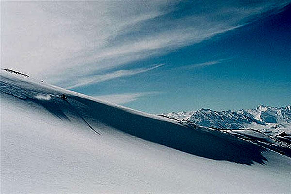
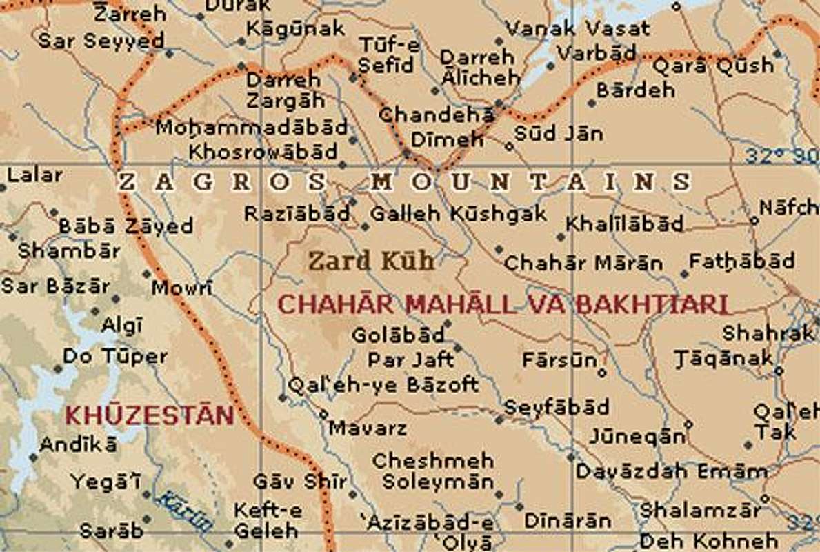
| Zard Kooh, ZardKooh, Zard-Kooh, Zard Kouh, ZardKouh or Zard-Kouh or the full name Zard Kooh-e-Bakhtiary is not the name of a individual peak but it's one the most great and famous sub ranges of Zagros range, the terms mean "The yellow mountain of Bakhtiarys". (I'll shorten the name to ZK in follow...) The mountain is located in Chaharmahal-e-Bakhtiary province (The cold season starts October, coldest -15 centigrade warmest 35.5 centigrade average 10.3 centigrade) near Shahr-e-kord and Koohrang cities, probably one of the most beautiful places of Iran, ZK is the source of two most major rivers of Iran Karoon and Zayandeh-roud of Isfahan. Chaharmahal-e-Bakhtiary people and nomads are the most nice people, they believe to be the best to the guests... ZK is the warm season source of the Bakhtiary nomads who deal with the hard mountain conditions. They breed sheep and goat and produce the best meat, wool, natural diary products and hand works. Bakhtiary's Kebab is one of the best Iranian foods you can have the original versions in this place. inverted tulip which grows abundantly on the slopes of Zardkooh (Yellow Mountain). This flower is unique to Iran. | ||||||||||||||||||||||||||||||||||||||||||||||||||||||||||||||||||||||||||||||||||||||||||||||||
| Most high known peaks | ||||||||||||||||||||||||||||||||||||||||||||||||||||||||||||||||||||||||||||||||||||||||||||||||
| The ZK sub range is made by a long north-west oriented to south-east ridge line with few sub ridges or parallel ridges. The ridge line can be divided into five sections with the following peaks located on each section. ZK geographical location is 49:30 to 50:20 E and 32:05 to 32:55 N. Normal routes are easy you will need suitable clothes and boots, tent and other equipments. But for routes marked you will need special equipment such as carbines, crampons, piton, hammer and etc. north to south: E-U-Lack:
Ab-Sefid and Lasouzeh:
Central part:
Chery peaks:
Meelly mountain:
| ||||||||||||||||||||||||||||||||||||||||||||||||||||||||||||||||||||||||||||||||||||||||||||||||
| Objects | ||||||||||||||||||||||||||||||||||||||||||||||||||||||||||||||||||||||||||||||||||||||||||||||||
| ||||||||||||||||||||||||||||||||||||||||||||||||||||||||||||||||||||||||||||||||||||||||||||||||
| About Iran and Chaharmahal-e-Bakhtiary | ||||||||||||||||||||||||||||||||||||||||||||||||||||||||||||||||||||||||||||||||||||||||||||||||
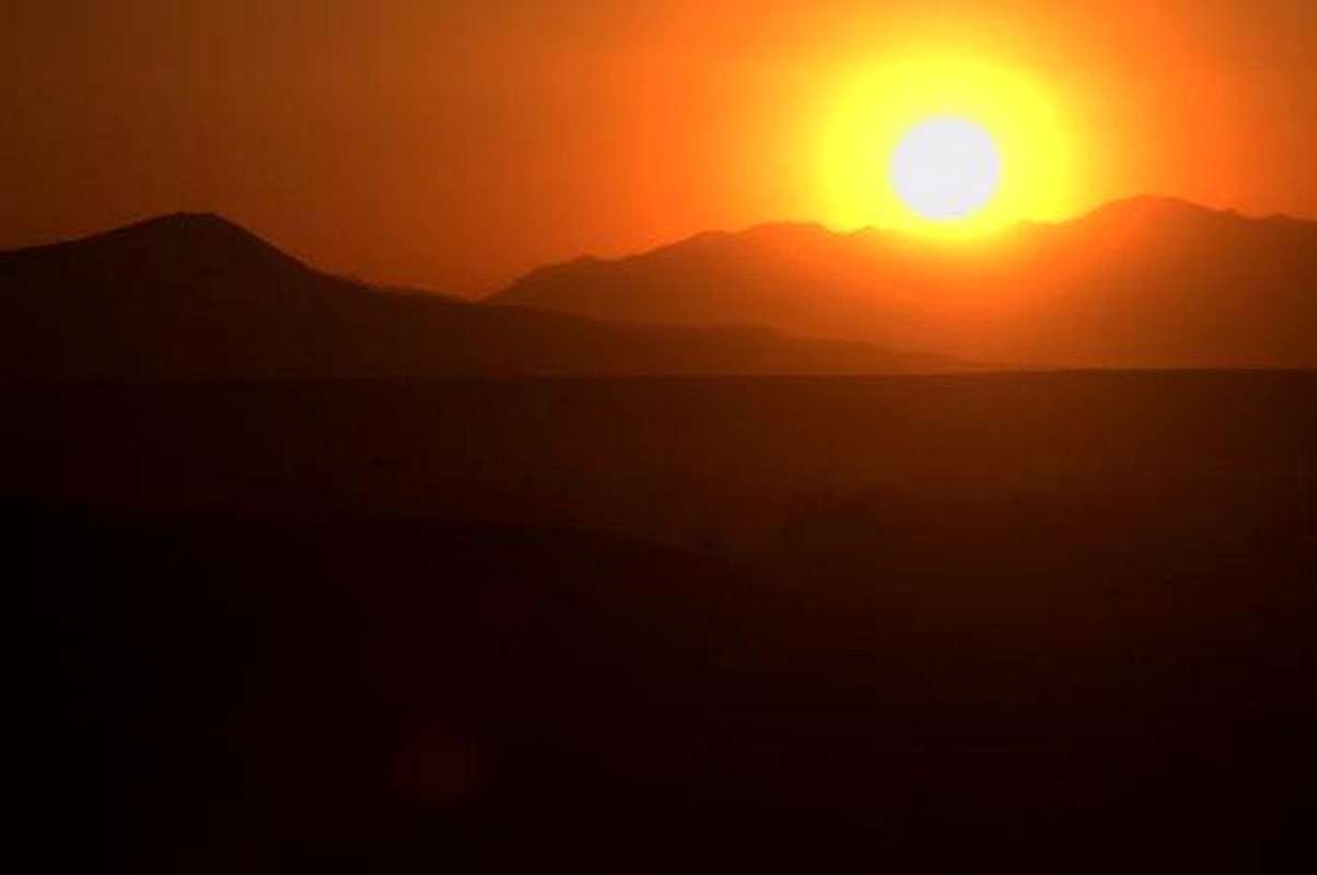 Sunset on ZK | ||||||||||||||||||||||||||||||||||||||||||||||||||||||||||||||||||||||||||||||||||||||||||||||||
| [I added this section to give a small glance to people who want to travel to Iran] Iran is high plane hosting two vast ranges of mountains Alborz and Zagros including hundreds of 4000+m summits. Even taught there are two big deserts in the middle of Iran still it's been said 3/4 of the plane is covered by mountains, there are still lots of 4000+m and 3000+m outside the Alborz and Zagros ranges scattered all over the Iran plane like Kerman mountains and Taftan volcano, the weather varies from dry hot to mountain conditions and to the thick green lush and humidity of the north Caspian sea coast. The behavior of Iranians is friendly and they are helpful to foreign people from Europe and America (this friendly behaves may no be applied to Arabs), you can quickly make a friend who would be glad to guide you and stay beside you and invite you to his/her home. The pipe-supplied and mineral water and food served in restaurants and supplied from stores is safe (avoid food from road sellers in downtown). Security is granted by the police, there are two kind of polices in Iran the green ones and the blue ones, blue is only for traffic control, greens are for security and criminal matters. | ||||||||||||||||||||||||||||||||||||||||||||||||||||||||||||||||||||||||||||||||||||||||||||||||
 |
Getting There/ Glimpse to the Routes

You have to go to Shar-e-Kord(center of Chaharmahal-e-Bakhtiary) 521Km far from Tehran:
Options:
- Fly to Shar-e-Kord
- Drive to Shar-e-Kord
- Tehran - Qom - Arak - Shar-e-Kord
- Tehran - Isfahan - Shar-e-Kord.
Climbing the east/north faces: From Shahr-e-Kord drive to Farsan city drive to Chelgerd (Koohrang) town a dirt road toward west goes into Koohrang river valley where the routes start, bypass Kooh-e-Karkonan(2900m) until you reach Koohrang dam. All routes start from Koohrang river valley up to the peaks.
Acording to the desired climbing region/peak :
- (1) Kaino Peaks
The very north part of the ZK's, when the Chelgerd road branches take the north branch and reach Sheikh-Ali-Khan village, the routes start from this place and are moderately hard and technical.
- (2) Haft Tanan peak
After raching Kooh-e-Karkonan before reaching the dam take the easy route north to E-U-Lack glacier up to the summit.
- (3) E-U-Lack
After raching Kooh-e-Karkonan before reaching the dam climb up the E-U-Lack glacier, the route is moderately hard and technical.
- (4) Ab-Sefid and Lasouzeh
Bypass the dam system and the bridge, go on the nomad's route go into Chal-e-Baharro valley take the Ab-Sefid route or the Lasouzeh ridge.
- (5) Sardan
Go on the Ab-Sefid route until it branches take the left, the route to Sardan and Chal-mishan glacier.
- (6) Dozardeh, Khersan, Shah-e-Shahidan
Bypass the dam system take the route to Chal Mishan shelter, climb the route up th Shah-e-Shahidan, traverse left on Poursoonan glacier to the other peaks. There are two more routes which rise up from Koohrang river.
- (7) Chery peaks
Follow Koohrang river south to Birgan the route starts from this place toward west and south-west
- (8) Meely mountain
Follow Koohrang river south to Birgan, Rostami and Do-Ab-e-Samsami the route starts from this place toward south
Red Tapes and Regional Hints
| ZK mountains are of one the protected areas of Iran, hunting is prohibited and fishing is prohibited out of season, anything harm to the pure nature is prohibited. Entrance to some protected places of Iran will require a license which you can grab from the mountaineering federation of Iran. |
| No fees of permission is required for climbing or camping |
| Keep in mind that ZK has been and is the natural home of the nomads called Ilat and Ashayer, specially the Bakhtiary's |
| Risk of avalanches and wild animals attack exists out of season. |
When To Climb
| Best | Dozardeh area: July-September Haft-Tanan and E-U-Lack area: late July Chery mountains: late June and July Sardan peak: July, early June for ice/rocksnow mixed technical climbs Ab-Sefid peaks: late June and July |
| Photography | Whenever |
| Summer | July and September means summer for ZK |
| Winter | The normal east routes are not technical but at winter heavy snow fall in Koohrang valley and bad weather conditions would make ZK one of the longest and hard winter attempts of Iran. |
Mountain Conditions
| Summer (July-October) | Weather is clear |
| Winter | Heavy snow, rough cold mountain conditions, frequent snow storms and wild winds that may last for days. |
Links and Books
| Links | Chaharmahal-Bakhtiary Province [GO] |
| Pictures of a winter attempt (winter 2004) [GO] | |
| Zagros Mountains forest steppe [GO] | |
| www.parsoon.com/alamkouh.htm [GO] | |
| Chahar Mahal & Bakhteyari[GO] | |
| Chahar Mahal & Bakhteyari[GO] | |
| Books | Mountaineering in Iran (Koohnavardi dar Iran) in Persian, by Ali Moqim This book is a good guide including maps, routes, conditions... and any basic information you need for climbing mountains of Iran, also includes a list of books about mountaineering in Iran. |