
|
|
Mountain/Rock |
|---|---|
|
|
50.96000°N / 14.08000°E |
|
|
Trad Climbing |
|
|
Spring, Summer, Fall, Winter |
|
|
1312 ft / 400 m |
|
|
Overview
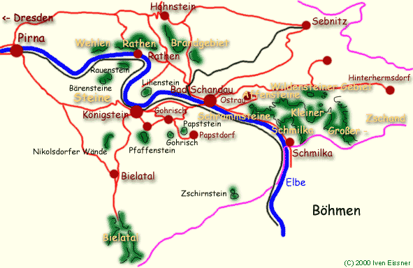
The tower is SW and just below the Ziegenrückenstrasse and directly east of the Türkenkopf.Here is a basic idea of the area's location and the main climbing regions.
Maps for each specific region can be found in the climbing guides,can be bought locally or ordered.
German Alpine Club information and maps
Routes
SE-Way
 The first ascent of Ziegenrückturm
UIAA VI. First Ascent Hellmut Schmid (Moni's Dad) and H. Schreiber, 26 Sept 1938. Climb into the SE face and traverse to the south edge, then climb along the edge to the summit. About 2 pitches.
Getting There
You usually arrive to the area through Dresden. You can easily reach Dresden city by car, plane or rail. From Dresden, you can travel by train or steamboat up the Elbe (SE) or by car on B172. A S-bahn (local commuter) train leaves Dresden about every 1/2 hour. The train travels up the left hand river side (when looking down stream). From there you have to use a ferry to cross the Elbe at Rathen. Car travel into the town and climbing areas is restricted. Traffic is often very heavy, especially during vacation times and on the weekends. Expect to hike to the climb you chose. Trails are well marked.For train schedules see: German Railways (This link works for most of Europe, by the way. At this page you can select English, French or Italian, before going on to the timetables. )
The Ziegenrückenstrasse is located on a ridgecrest above the village of Rathen. From Rathen it is about a 30 minute walk. Take the Füllhölzelweg (Riekeweg)that leads NE out of town to the Riekefels, take the left hand fork and then shortly after the right hand fork (Buttermilchloch). A trail leads to the right (east) called the Querweg that connects to the Ziegenrückstrasse. The tower is on the Querweg.
Red Tape
The sandstone here is extremely soft. The passage of thousands of climbers has unfortunately left its mark as footsteps and rope drag marks engraved into the rock. Erosion of the sandy slopes has contributed to the damage. Some of the towers are collapsing, despite such efforts as bolting and wrapping metal bands around them! As such, some of the classic towers are now off limits to climbers. Routes and summits are constantly reevaluated for closures as are summits in areas deemed fragile in terms of plant and animal life. Trails must be followed and cross-country travel is discouraged (and really not necessary).For an update to closures, go to the section on "Sperrungen": Climb Closures Closures also happen during critical bird nesting times.
There are restrictions on climbing equipment. No metal protection other than the rings already present may be used. The permanent rings are often very far apart. If intermediate protection is desired, creating sling knots, threading sling through holes in the rock (Sanduhr) or looping a sling around rocks is allowed. Given that the rock is so soft, I don't think any of this would really hold. As a family friend explained to me once- if you fall, then you overestimated your abilities and you shouldn't have been there in the first place! Chalk or any other chemical is forbidden.
 Rope wear in soft rock
In most areas, you may not climb when the rock is wet.
The locals take these ordinances very seriously. Considering the damage that is everywhere apparent, every effort should be made to make your passage as low impact as possible.
You do not need to register or anything.