
-
 4321 Hits
-
 74.92% Score
-
 5 Votes
|
|
Route |
|---|---|
|
|
46.38548°N / 13.38598°E |
|
|
Hiking |
|
|
Summer, Fall |
|
|
Most of a day |
|
|
Medium hard walk-up |
|
|
Rating The Tour (With Hiking Standards)
0. General. From 1120 m to 2324 m, slopes orientation north, on top east and south. Till Goriuda meadow a difficult, exposed path, on many places protected with steel ropes, but with also some unprotected passages. Further on easier. Gear: Only good shoes and poles. Don't do it when snow lies in woods (or let alone ice).
1. Effort: 1300 meters of altitude, 4 hours 30 minutes.
2. Power: 1 - no difficulties (only walk-up).
3. Psyche: 3 - medium, a few unprotected passages through steep woods, only a tiny path, exposed.
4. Orientation: 2 - easy (taka care on the section before Goriuda meadow).
Overview
The direct ascent from Sella Nevea on Peravo saddle looks shorter and faster than the detour via Rif. Gilberti (disregarding the help of cable-car, of course). But the lower part of the path is a bit harder, so not allowing you to ascend quickly. It also goes on a few places up and down. But regarding the landscape this is certainly a very recommendable approach. It is best to go here up and return by Rif. Gilberti.
Route Description
From below the western side (near picnic places, a small football place) of Sella Nevea, you take a marked path, which at first only gently ascends over the slopes towards the West. At first the path is well marked, soon in the woods it branches. Both branches are announced to go on Goriuda meadow. The right variant is straightforward, the left one ascends considerably and on the other side of the rocky ridge descends again. I have no experience with the latter path. The direct path soon approaches a wild rocky area, which is (obviously) arranged for climbing. You continue by the marked path, which starts to ascend considerably, using narrow ledges over the rocks and a steep terrain. You constantly cross the slopes towards the right, gain altitude, but in some places the path goes also a bit down to find another passage. The terrain is more and more hard, but the path here is still perfectly secured. Through the next forrest section you ascend to the second rocky barrier, overcome it by another system of ledges and finally exit over a steep forrest slope. Here the path is not protected any more, you need to be very careful if slippery, because it is really exposed. Especially can this place be tricky on a descent. When above in woods you need to follow the path carefully to the Goriuda meadow. This part is almost not marked at all, but the path is clear enough to follow it.

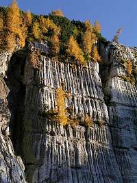
On Goriuda meadow you continue the ascent over the forrest slopes more straightforwardly up. As from Raccolana valley the path No. 645 joined us on Goriuda, now the path is strong and well marked. After some 300 meters of ascent you reach a wonderful natural phaenomenon - a high karstic wall on the left, which is carved by thousands of channels on its whole height. You continue by the valley, the terrain is more and more opened and soon you exit on the high Kanin karst plateau. Now the path is winding through shallow valleys, in one or two places you also descend a bit and so approach the final slope below Peravo saddle. You join the path, coming from the left from Rif. Gilberti just before bivouac Marussich, 2040 m.
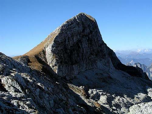
From the bivouac the marked path on Žrd / Monte Sart first ascends in a few turns up below the summit of Vrh Grubja / Picco di Grubia, then crosses its northern slopes on a grassy saddle below the eastern summit of Žrd / Monte Sart. There the better marked 'Via Alta Resiana' continues over the southern slopes, so we must deter right and by a tiny path ascend the eastern summit by its narrow ridge. The path is more and more panoramic and we are soon on the first summit. There you need to decide whether to go another 20 minutes on the only 3 meters higher western summit. If yes, you scramble all the time by top of the ridge, overcome the middle summit and finaly reach the so desired goal. 1 h 30 min from the bivouac.