Toggle navigation
Mountains
Routes
Images
Trip Reports
Forum
What's New
People
Areas & Ranges
Articles
Trailheads
Canyons
Huts & Campgrounds
Albums
Logistical Centers
Fact Sheets
Lists
Custom Objects
Gear
Plans & Partners
WELCOME TO SUMMITPOST
SIGN IN
REGISTER
Grandeur Peak
Additional Parents
Image
Grandeur Peak Routes...
View High-Resolution Image
Grandeur Peak Routes...
Grandeur Peak Routes Overview Map
Trail
,
Class 1
,
Class 2
The yellow rock climber symbols mark cragging areas.
A
-
Church Fork Trail
B
-
West Ridge Trail
C
-
West Ridge Trail variation
D
- Pipeline Trail
E
- Rattlesnake Gulch Trail
F
-
Dragon's Tail Ridge
G
-
Pharaohs Glen
H
-
Millcreek Ridge - Church Fork Pk
I
-
Thayne Canyon Trails - Thayne Peak, Mt Raymond
Information is a combination of personal experience, USGS topos, and route descriptions on SP. Please let me know if any additions or corrections are needed in the map or labeling.
« PREV
NEXT »
PellucidWombat
on
Jul 15, 2005 6:07 pm
Comments & voting
Other parents
Lat/Lon:
40.70700°N / 111.7592°W
Image ID:
114927
13728 Hits
73.06
% Score
3
Votes
Log in to vote
Comments
No comments posted yet.
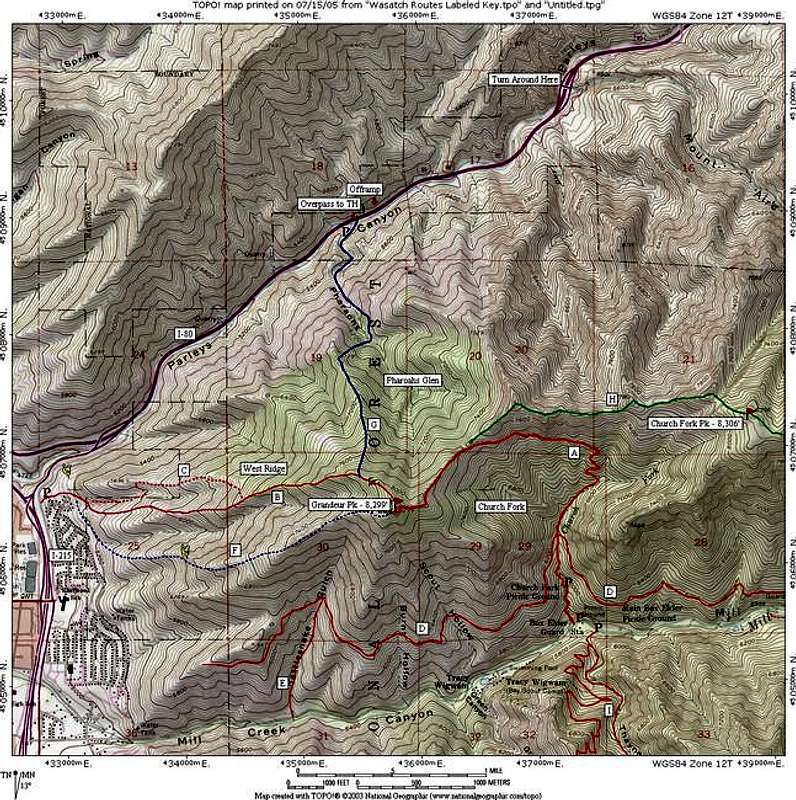
to post!
Don't have an account?
Grandeur Peak
(Mountain/Rock)
« PREV
Viewing
#50 of 108
GALLERY
NEXT »
PellucidWombat's Image Gallery
« PREV
Viewing
#1292 of 2324
GALLERY
NEXT »
×
You need to login in order to vote!
User Name
Password
Remember me
Forgot your password?
Log me out when I close my browser.
Keep me logged in all the time.
sign in as a user
Don't have an account?
Register now for FREE
Rating available
Suggested routes for you
People who climb the same things as you
Comments Available
Create Albums
Register Here