
|
|
Route |
|---|---|
|
|
36.66330°N / 114.8873°W |
|
|
scramble |
|
|
Most of a day |
|
|
class 2-3 |
|
|
Approach
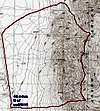
From the i-15 off-ramp at the divergnce of route 93, drive 20.7 miles north on route 93. Park the car as far off the shoulder as possible.
Route Description
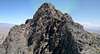
From us93, head east across the bajada to the bottom of the large wash at 36.6523802, -114.8974773 (WGS84). Take this wash ENE then E to the ridge crest, intersecting near the 4324T mark on the 1986 topo. From the crest, turn NNW and N and walk along the ridge. Peak 5226T requires class 2 scrambling; there are a few sections of class 3, but one can avoid these by cutting to the right (E), then back to the crest.
From Peak 5226T, the traverse N to Arrow 5205 is more rigorous; the km between the peaks may take an hour. The direct route is up to class 4; however, one can nearly always cut to the east (right) for class 2 and 3 climbing, the cut back W to the crest.
From Arrow 5205, continue N and NNE to near the point marked as 4316T on the USGS 1986 map (36.6786261, -114.8852374 WGS84). The terrain is noticeably easier here, and transitions from dark gray ragged limestone to gently sloped tan talus. Turn W, then NW, to descend the canyon. You can travel on either side of the rocky lump to the NW; either route (N or S of the lump) is class 2. This is one of the few class 2 canyons in the range, so it is important not to undershoot or overshoot this descent point.
Follow the drainage NW until the canyon empties onto the bajada, then turn SW and W and cross the desert back to the road. You will probably have to walk the road for a mile or two south, back to your car; if desired, one can walk on a rough gravel road just east on the highway, to complete the loop back to the car.
The full hike is 9 miles long, with over 3400' accumulated elevation gain, and is rough and completely TRAILLESS.
 |  |  |  |
Essential Gear
Bring plenty of water, no matter the time of year. The rock is very frictional (except on dryfalls), consisting of silica protuberances in a limestone matrix; however, sticky rubber soles will be appreciated during the boulder-hop portions of the climb. Very few people travel this route, so loose rock has not been preened. There may be cell phone service on the crest, depending on carrier (Verizon works with good Moto phones). Desert gaiters are useful for crossing the low-altitude sections. Some people wear gloves for this kind of terrain; certainly the rock will tear up your hands. A 50' piece of 3/4" tubular webbing (2500 lb static) with a carabiner will provide extra comfort if you get confused; be prepared to leave it behind. Finally, a GPS is very useful in finding the correct canyon. Since this is a rather long trip best done on a winter day, an emergency headlamp would be useful. Note that the last 3-4 miles are in gentler desert or even on roads, so they can be traveled in dim light.
Miscellaneous Info
If you have information about this route that doesn't pertain to any of the other sections, please add it here.