Preface
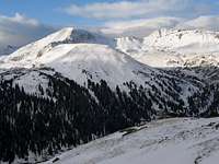
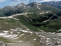
![Mountain Boy Gulch]() October
October
The 12093 ft Independence Pass sits on Route 82 between the towns of Aspen and Leadville, Colorado. Three high points are visible on a ridgetop to the south of the pass. North to south, these include: Point 12812 ft, Point 13020 ft and Unnamed Peak 13198 ft. I had been to Independence Pass on multiple occasions and had noted a trail that seemed to go toward the high points. In early October of 2009 I had gone to hike the trail but snowfall the night before, along with cloudy weather, below freezing temperatures and strong winds had forced me to turn back. I was finally able to hike the trail in July of 2010. It gave me easy access to the tops of the first and the second high points. I did not go beyond the second high point because it required going down an unstable scree-covered slope with a big drop off below it.
Statistics
![Map]() Map
Map 12093 ft
Maximum Elevation: 13020 ft
Roundtrip Distance: 5.16 miles
Wednesday July 7, 2010
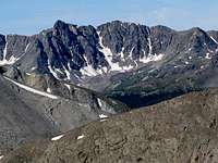
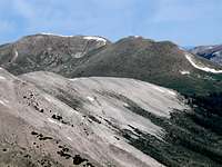
![Near Independence Pass]() Points 13198 ft & 13020 ft
Points 13198 ft & 13020 ft
Having done strenuous hiking over the last 3 days, Chris and I were looking forward to the “leisurely nature” of today’s agenda. Starting the hike at Independence Pass had the added advantage that it did not require a time consuming drive on a nasty dirt road.
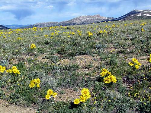
We left Snowmass Village at 7:30 a.m. and drove to Independence Pass. A parking lot has been built at the pass. Most tourists who come to the pass stop there for a few minutes to enjoy the view, There were already many people at the pass.
![Mountain Boy Gulch]() (L) Peak 13198 ft & (R) Point 13020 ft
(L) Peak 13198 ft & (R) Point 13020 ft
We started to hike at 8:50 a.m. We went away from the crowds and got on the trail that went toward Point 12812 ft. All 3 high points were visible to the south. Beautiful alpine tundra covered the surrounding slopes.
Menacing clouds had already begun to form to the northeast but fortunately they seemed to be moving away from us.
There was no one else on the trail except for a lady who was hiking alone. After a while, Chris told me that he did not want to continue. He was concerned about the clouds. Given the fact that the entire route was on a high exposed ridgetop, we were certainly prone to being struck by lightning. I separated from Chris but I told him that I would keep in touch with him via the walkie-talkie.
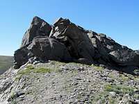
The trail followed the ridgetop over a gentle slope. As I went higher, the alpine tundra was replaced by talus. Big snow cornices could be seen just below the ridgetop to the left (east).
Many of the nearby peaks had now come to view including
Green Mountain (which I hoped to climb the next day) and
Anderson Peak (which I had climbed 2 days ago). The wall at the base of the North Truro Peak had also become visible. I had read about this wall but had never seen it.
![Anderson Peak]() Anderson Peak Anderson Peak | ![Petroleum & Truro Peaks]() North Truro North Truro |
![Green Mountain]() Green Mountain Green Mountain |
![Truro Peak]() North Truro North Truro |
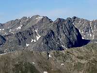
I then reached the top of Point 12812 ft. Points 13020 ft and 13198 ft were now well-visible to the south again.
![Point 13020 ft & 13198 ft]() Points 13198 & 13020
Points 13198 & 13020
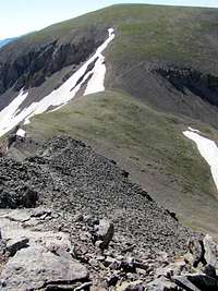
The trail continued south on the ridgetop and went down to a 12700 ft saddle and then began to go up the rocky slopes of Point 13020 ft. The impressive north face of Grizzly Peak had now come into good view.
![Rocky slopes of Point 13020 ft]() Rocky Slopes Rocky Slopes | ![Grizzly Peak]() Grizzly Peak Grizzly Peak |
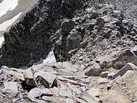
Once I reached the top of Point 13020 ft, I noted that to continue hiking toward Unnamed 13198 ft, I had to go down a short but very steep slope that was covered by loose scree. There was a big drop off below the slope. I tried to go down but my backpack and camera bag reduced my maneuverability. Storm clouds were also brewing not far away so I decided to just stay on top of Point 13020 ft. I called Chris and told him that. My GPS showed that I had hiked 2.57 miles.
Grizzly Gulch sat directly to the south of me. Grizzly Peak rose at the southern end of the gulch.
![Grizzly Peak & Grizzly Gulch]() Grizzly Peak & Grizzly Gulch
Grizzly Peak & Grizzly Gulch
To the east, an alpine basin that was filled with boulders sat directly below the steep slopes of Point 13020 ft. This basin is known as Mountain Boy Park.
![Mountain Boy Park]() Mountain Boy Park
Mountain Boy Park
Independence Pass could be seen to the northeast. Parts of Route 82 near the pass were also visible.
![Independence Pass]() Independence Pass Independence Pass | ![Looking North]() Looking North Looking North |
After a few minutes, a man and a woman came to where I was sitting. They were a Norwegian couple who were driving from Chicago to Seattle for a hiking and sight seeing trip. Their next destination after Colorado was Canyonland National Park. They had traveled extensively throughout Europe and Asia. They told me that they had been to Iran too and had climbed
Mt. Damavand and
Mt. Sabalaan. I told them about my climbing adventures in Iran.
We got busy talking and time went by fast. Chris called me and reminded me that the cloud situation had much worsened. He told me to leave as soon as I could.
I said goodbye to that couple and left. Near Point 12812 ft, I ran into that hiker lady whom we had seen in the morning. She was afraid of being struck by lightning and asked if she could walk with me. She was from Boulder, CO and was in the area for a hiking trip.
![Point 12812 ft]() Point 12812 ft
Point 12812 ft
As we approached Independence Pass, thunder and lightning began in the mountains across the valley. I called Chris and told him that I was only 15 minutes away. A few drops of rain began to fall.
It was very crowded at Independence Pass. I saw a teenaged girl picking wild flowers but I did not have the guts to mount a protest. I said goodbye to that hiker lady and went to Chris who was waiting for me in the car.


Comments
Post a Comment