Chilling
![Le Doigt de la Fausse Brèche / Dedo de la Falsa Brecha (or Maillet) and Le Taillon]() Le Doigt de la Fausse Brèche / Dedo de la Falsa Brecha and Le Taillon Le Doigt de la Fausse Brèche / Dedo de la Falsa Brecha and Le Taillon |
It’s around 8 p.m. and it’s the second day of our vacation. I’m relaxing in our apartment in
Guchen near
St. Lary reading a book and sipping my (excellent) wine. I’m trying to get over the frustration of not having reached
Pic de Campbieil today and P.G. Wodehouse plus the good Roussillon vintage appear to be cheering me up. I had to fight dizziness and heavy legs midway during our ascent and though after lunch I felt better my boss decided that the summit was off limits for me today.
Now she’s sitting beside me texting with her sister who happens to be in
Luz-St. Sauveur, two valleys to the west. The two want to join for a hike and are now busily plotting the details. “Li suggests the
Brèche de Roland and
Le Taillon. Have you looked at the guidebook?” I had and immediately I know that this won’t be possible. We’ll have to drive for two hours across two passes to reach Lioba (Li) and another hour to reach the trailhead. The guidebook claims it’s four hours to the
Refuge de la Brèche and 2 hours to the summit. Another three hours worth of drive and we’ll be busy for 11 hours. Add two hours for lunch and other breaks – it won’t do! We’ll probably just manage the refuge and little more.
I say so and the suggestion is off the table – until next night when the ladies call each other and decide that they want to attempt the Brèche after all. I’m afraid we’ll be disappointed but after today’s hike across four summits I feel much better than I did yesterday. Maybe this is the reason why I agree. Of course I won’t get Judith get up early so I suggest that at least we’ll set the alarm at our usual time: 6 a.m.
The "Bike Path"
![Vallée de Barèges]() Vallée de Barèges with the Tourmalet Road
Vallée de Barèges with the Tourmalet Road
The
Brèche and
Le Taillon are a (maybe THE) Pyrenees classic route but before we reach the trailhead we’ll have concluded another one. Between
Arreaux and
Luz St.-Sauveur there are two road passes,
Col d’Aspin and
Col de Tourmalet and at least the latter has been part of the
Tour de France in almost every year of its existence. Since my college days I have never been able to watch the Tour on TV but in the last years I had the tour ticker running on my desktop at work. This year the stage went from
Arreaux across both passes and from
Luz-St. Sauveur a third ascent took the riders to
Luz-Ardiden. As usual it was dramatic and this year even more so since I knew I would be visiting the area a few weeks later.
So we drive the 6km from
Guchen to
Arreaux and turn left on the narrow road to
Col d’Aspin. We managed to get on our way before 7 a.m. and thanks to my reckless driving reach the pass at about 7:20 a.m. On the other side I slow down a little and cruise the switchbacks to
Sainte Marie de Campan. It is still early and the road is empty but right before we reach Sainte Marie a truck slows us down. Before 8 a.m. we reach the village, the truck turns right while we turn left, direction
Tourmalet. The road is wide but there are many small villages and I can’t go as fast as I would like to. Beyond
Artigues the road gets steep and soon we are in
La Mongie. It’s hard to drive through here without a feeling of revulsion: this is as ugly as can be. Created on the drawing board solely for ski tourism huge hotels rise beside the road, now dead as nobody needs them in September. Ski Lifts mar the slopes and the best you can do is speed up to get through without puking.
A few kilometers beyond we reach
Col du Tourmalet, not as bad but ugly with its statue of a naked biker. We come up from behind and have a perfect look at this monstrosity. Judith chuckles but now we are on the other side of the saddle. Here the scenery is completely different. The slopes are very steep and the road has narrowed to a real mountain road. Still there are ski lifts but the hotels are missing. I start to feel a bit better. Rolling down through
Barèges we reach
Luz-St. Sauveur. A few kilometers in direction
Lourdes and we are at Li’s apartment. It’s 8:30 a.m., half an hour earlier than I anticipated.
She is prepared but her sister needs to have a look at the apartment before we drive on. While she does so we put Li’s stuff in the trunk and discuss the incredible weather we encountered here. So far barely a cloud. Today is supposed to be a bit worse but from tomorrow on the forecast calls for seven days of cloudless skies. The apartment inspection having finished we get into the car and head out for
Gavarnie. Li knows a back road, shortcutting
Luz-St. Sauveur and soon we are on our way again. Roads are narrow, there is quite some traffic but we get along quite well. In
Gedre there is a restaurant “La Brèche de Roland” and for a few seconds we can see today’s destination. In
Gavarnie we head for the ski runs (again) and drive up to
Col de Tentes. I park the car at 9:45 a.m. still earlier than I thought. But also much later than I like to start my hikes.
Stage 1: To the Refuge!
![Pic des Gabietous]() Pic des Gabiétous
Pic des Gabiétous
The
Brèche is hidden from where we start but we can see part of the Cirque de
Gavarnie.
Le Taillon and
Pic des Gabiétous both have a cap of clouds but so far the weather still looks promising. And I know we won’t reach either summit. We ask ourselves why there is a road from
Col de Tentes to
Port de Boucharo / Porto de Bujaruelo and since it is there why it is closed to cars. Nowhere else in the region have we found closed roads so far. An obvious reason would be rockfall or the deep potholes we have to negotiate so that at least the second problem is solved. The saddle greets us with a good but hazy view. Today’s weather doesn’t promise to be stable.
From the saddle we start on the path to
Refuge de la Brèche de Roland. At first it rises a bit, negotiating the utmost north ridge of
Gabiètous. After this the path gets almost level and we happily hike along towards the pinnacle of
Petit Sarradet. Will have to climb the Col, which separates it from the big Sarradets? It turns out we don’t. Instead the path turns a corner and heads up beside a rushing creek. Suddenly the terrain gets steep and we find (very loose) cables to guide us upwards. Here the groups, which had been passing us on the level part, suddenly slow down and let us re-pass. Everything is polished, slippery and wet. Some of the cables are so loose that we decide not to touch them, others are beneath knee level and thus a pain to use. What are they good for? Judith explains that in early summer you have snow and ice in this place requiring crampons and ice axes. We feel lucky we came that late in the year.
With the tricky section over the path starts winding in numerous switchbacks towards a cirque which is bounded by the north faces of
Taillon and
Pointe Bazillac. As we get higher we see that there is even the rest of a glacier inside. We cross over to the eastern side and ascend towards a saddle. And here we finally see the
Brèche for the first time. And with it appears
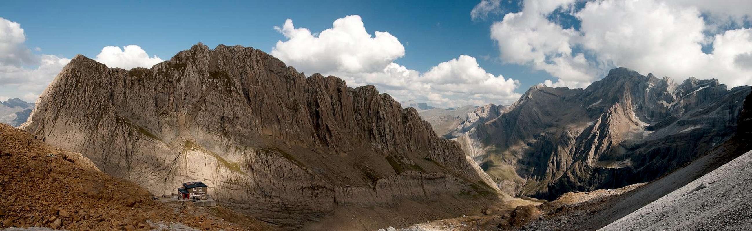
Refuge de la Brèche de Roland. The remaining few hundred metres lead across blocky terrain, not difficult but rather strenuous. To our left the big faces of
Les Sarradets rise to the sky. They look like good climbing ground with their gullies, chimneys and cracks.
Stage 2: La Brèche de Roland
The use of the toilet at the refuge is not possible. Somebody seems to be fighting with demons inside. We forgo a break and instead immediately start for the
Brèche. From the refuge it looks like a big scree slope leads directly into the cut and given the slow speed others are hiking upwards it seems to be steep and strenuous. I quickly gain on my two partners who keep talking to each other and consequently slow down. Both are not very talkative but once they are together they can’t stop. Strange …
Halfway up the slope I pause to take a photo of
Les Sarradets and the refuge,giving them a chance to catch up. Finally I reach a plateau, about 200m beneath the Brèche. Judith discovers a kind of platform in the direction of
Cirque de Gavarnie and the two saunter off without giving me the time to point out that we should go there upon our return only as the light will be much better by then. “Silly photographers” – I know when I have been overruled.
A few shots and we return in the direction of the
Brèche. The guidebooks warns that we’ll have to cross a glacier in this place. True – but the remaining ice is covered by dirt so that you have to look closely to see it. The “crossing of the glacier” is quickly done and we head for our final ascent. First we have to ascend a ramp but then the final and very steep switchbacks require our attention. However, in a few minutes we stand underneath this giant portal. According to legend Roland, knight and nephew or Charlemagne, forced the crossing of the Pyrenees by striking the mountain with his sword. We gaze up and around. Clouds hover around
Le Casque and a fierce, cold wind blows through the gap. Avoiding the crowds we head to the right (west) and find a solitary place underneath the overhanging rocks. There’s no wind here, the sun is shining and we decide that this is the place to have lunch. It is exactly 12 o’clock.
Stage 3: Le Taillon
![Ordesa View]() Ordesa View from our overhanging cave
Ordesa View from our overhanging cave
In our cave – the overhanging walls give us this impression – we ask ourselves what to do now. People pass us on their way to
Le Taillon and back so that the answer becomes obvious. Lunch finished we’ll give it a try. Our first 3000er in years. Again we consult the guidebook which is full of warnings about the
Fausse Brèche, another gap on the way to
Le Taillon and about the mountain’s east ridge as well. From our cave we can’t see it, just
Le Casque and the plateau-like mountains of
Ordesa. From above water keeps dripping down in front of us and as clouds move across the sun we quickly get cold.
![Looking back at the Brèche and the Casque]() Looking back at the Brèche and the Casque
Looking back at the Brèche and the Casque
So we pack our things and head out of our cave, scrambling along underneath the overhanging walls. There’s a place where we have a good backwards view of the
Brèche but then it’s hidden as we turn a corner into the next cave (this time a real one). Water keeps dripping on us and the cave seems to be nesting ground of birds of prey. We hear a lot of their calls. Further onward we pass a group of four women and then start the ascent to the
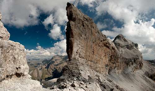
Fausse Brèche, another gap, which separates
Pointe Bazillac from
Le Doigt de la Fausse Brèche, a small thumb or tooth. It looks like transported from the Dolomites – it could be one of the
Cinque Torri.
Behind, the big brown bulk of
Le Taillon appears and with it the path along its east ridge. Why this should be difficult is more than we can comprehend. It’s not even steep! But the path around
Le Doigt might be what the guidebook author had in mind. Not difficult but a bit exposed. With rests of snow this might turn nasty. But here and now the ground is dry so that we negotiate the tower and head out onto the broad east ridge of
Le Taillon.
![Looking back towards the Fausse Brèche]() Looking back towards the Fausse Brèche
Looking back towards the Fausse Brèche
A further rocky section needs to be passed but then we are on the well trodden scree of the mountain. The views get worse as clouds still hover around the summit and we quickly stand on its plateau-like top.
Stage 4: The Race to the Refuge
![Summit Heroes]() Summit Heroes
Summit Heroes
There’s not much to see up here but the clouds keep moving and every now and then it is possible to take a glimpse in one of the directions. The north-west is open but it takes several minutes for
Gabiètous to appear. One party prepares for leaving as another party arrives. A couple also leaves when three of the four women we passed near the
Fausse Brèche join us. Minutes later the fourth appears in the mist and is cheered on by her pals. We take a group summit shot and also prepare to head down.
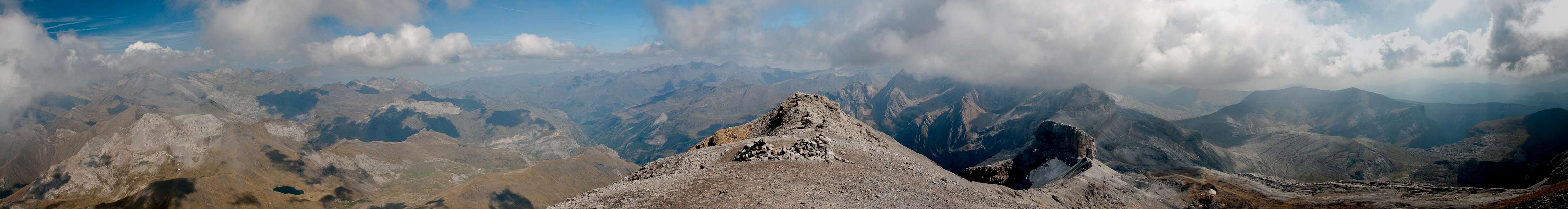
220° view during the descent of Le Taillon |
The path is easy and we take large steps. The lower we get the wider the views and I step aside every now and then to document them with the camera. We pass the couple before a steeper section, then wind our way downwards. A school of griffon vultures appears and with no effort at all glide along the ridge. We count seven of the huge birds, which are too far away for a decent photo. As we get closer to the
Doigt another pair of birds sails along. This time they are Milans Royal, Red Kites. Beautiful birds!
At the
Doigt the sisters pose for another photo, after which we scramble along its side towards
Pointe Bazillac. A last shot of the
Doigt and the overhanging walls have us back. While the ridge was cold and windy here the sun has been heating up the stone for hours and we feel more comfortable. On
Le Casque we see a few climbers near the summit. I’m wondering how they got there. Later my guidebook will give me an overview over the routes. We reach the
Brèche and have a wonderful view through it into the
Cirque de Gavarnie below. The crowds have gone now and the lingering hikers all prepare to leave. There is a dad with his two sons, maybe 5 and 7. To be here is a huge achievement for the kids. The father must be one hell of a motivator! They start the descent to the hut right before us but due to the kids’ short legs we soon pass by.
![La Brèche de Roland]() View through the Brèche de Roland into the Cirque de Gavarnie. To the right le Casque.
View through the Brèche de Roland into the Cirque de Gavarnie. To the right le Casque.
I, in particular, have long legs and jump down the steep part of the descent ahead of the sisters who still have a good conversation going. I don’t stop until I cross the “glacier” and head up to the plateau. There I meet the couple who left the summit of
Taillon right before us and they claim that we are real fast hikers. “Not at all” I reply trying to explain that they have come the same way in the same time. Somehow they don’t seem to get it. But anyway, Judith and Li join and I rush off again. Now the couple seem to have understood my meaning and appear to be racing me. I decide I don’t care and soon they have passed.
Les Sarradets and Cirque de Gavarnie |
Still something keeps my engine going at a high rate and in no time I have descended the scree slopes, standing in front of the hut. While I shoot a few panoramas the ladies catch up. We decide we’ll have a break in the saddle beside
Les Sarradets since we see there’ll be sun and even a view.
Stage 5: Down and Out
![Saddle View towards Vignemale]() Saddle View towards Vignemale
Saddle View towards Vignemale
An apple later we get up and leave. Again I rush ahead taking the switchbacks back into the cirque underneath
Taillon. Soon there’s a good distance between us and it’s getting larger by the minute. After a while I see the cabled section but is this really where we climbed up? I have to look twice, then again and finally decide it must be here. But the creek, which in the morning was rather small, has swollen in size. It carries three or four times as much water as before and the section now really gets tricky. It is still polished and slippery but the force of the water also presses you down. Bad as they are – now I’m happy about the cables. I almost slip but catch myself – only my left knee suddenly hurts. But after negotiating the section I wait for Judith and Li and forget about the knee – for now.
![Cirque de Gavarnie]() Cirque de Gavarnie
Cirque de Gavarnie
Now that the interesting or difficult sections are behind us, trudging back to base gets boring. We head for
Port de Boucharo with only little ups and downs. The descent from the
Gabietous north ridge makes my knee sting but once we are in the saddle the road back to
Col de Tentes awaits us. The shadows are getting longer – it’s the end of September after all – and the clouds retreat. As we get back to the car it’s only 4 p.m., however and we have hopes to get back to
Guchen in time. One last shot of
Le Casque through a saddle and off we go.
Over and Done
![Le Casque]() Last Glimpse of Le Casque
Last Glimpse of Le Casque
Now, almost four weeks later, I can’t remember the details what happened next. Somehow we took forever to get to Li’s apartment. Slow tourist cars were crawling down from
Col de Tentes, even slower cars were heading back from
Gavarnie to
Luz-St. Sauveur. We took the back road and delivered Li back at her holiday apartment. Restrooms, then fill the water bottles and off we go again. The
Tourmalet Road is empty and we get some good speed up there. While cruising down the other side my left knee starts to throb each time I step on the clutch. I put the car in third, trying to avoid the pain. However, as we hit the road to
Col d’Aspin I have to switch gears again. Up at the Col the pain is intense. Again I go back to third and cruise on down to
Arreaux. The 6km to
Guchen are quickly done and then I try to get out of the car.
Holy shit! Standing is possible but any move that slightly bends the knee makes me want to scream. Somehow I make it inside. Somehow I even manage to go through the dinner cooking routine. I even eat but before the desert I have to lie down. Day four of the vacation and I’m already down! With seven days of good weather on the forecast! I feel like screaming out loud! But keeping the leg straight reduces the pain and half an hour later I can move slowly again. A glass of good wine pushes up my spirits. But I know that at least tomorrow will be a full failure. Maybe I’ll have to spend a day at the shores of a lake!
I’m old!


Comments
Post a Comment