
|
|
Route |
|---|---|
|
|
40.61320°N / 75.9117°W |
|
|
Hike |
|
|
Half a day |
|
|
Walk-up |
|
|
Approach
From the small hamlet of Hamburg, head East on Street Rd (Old Rte. 22). Follow out of town for a little over a mile and take a left on Reservoir Rd. Follow about a mile (travel under Rte 78/22) past an intersection. Continue up Resevoir Rd. to the gate below the resevoir.
Route Description
There is a good sized parking area just below the yellow gate which looks to be locked all year round (at least it was during my visit in November). Next to the gate is a map displaying the trails up to the Pinnacle and points beyond.
Travel up the road until you reach the fork. There is a somewhat confusing sign which will point you in the general direction of the Pinnacle and Pulpit rock. I will describe how I got there, anyone else who knows the way, please feel free to clarify. Turn right at the sign and cross a small bridge. After crossing the bridge, follow the road up a few hundred feet until you see a side road on your right. Take the side road and continue to the right into the woods. The trail will descend slightly and shortly you will arrive at the Windsor Furnace Shelter.
The trail to Pulpit Rock continues past the shelter and a small privy on the left. A short ways up the trail you will see the trail from Blue Rocks on your right. Take the white blazed trail to the left when you first get the opportunity. This trail winds and ascends gradually up and around, eventually arriving at Pulpit Rock (stay to the left and don't take the side trails unless you wish to skip right to the Pinnacle). There are some mild scrambling opportunities on the South side of the ridge to Pulpit Rock which are probably less fun when not snow covered.
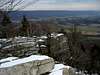
The trail gets rocky and just before reaching the Pulpit Rock "summit" you'll see an observatory on your left. Continue past Pulpit Rock, following the ridge (and the white blazes) for about 2 miles until you reach the large rock cairn marking the turnoff to the Pinnacle Overlook. There are also some opportunities to traverse/scramble on the other side of the cliffs at Pinnacle. Descend either the same way, or follow the A.T. to the North to make a loop.
Warning: The trail from this point past the Pinnacle is extremely boring. For a more interesting and quicker descent follow the white blazes for about a mile past a small clearing. Past the clearing look for blue blazes on your left. Take the blue blazed trail down off the ridge and cross a small stream. Follow the path to the reservoir and continue past to return to the parking lot.
 |  |  |  |  |
Essential Gear
Nothing more than some sturdy hiking boots and water. Skis or snowshoes could probably make for an interesting winter outing if given enough snow cover.
Miscellaneous Info
If you have information about this route that doesn't pertain to any of the other sections, please add it here.