Washed Out Plans
The aggravating beep-beep-beep of my alarm clock went off at 2:30AM, which I had purposefully set to allow myself enough time to complete the
Indian Peaks Traverse while traveling from downtown Boulder, with the intent of still making it back for supper with my wife while on vacation in Colorado together. From the get-go, the adventure began. About a week prior to our trip, Colorado was rocked by “biblical floods”, which more or less left a number of towns saturated in several feet of moving water and countless roads rendered impassable or completely destroyed. Up to this point, while traveling for a few days in and around Denver, Golden and Boulder, my wife and I had not seen any ill-effects of the natural disaster. I imagined the damage to be in more remote areas or mountain passes directly along waterways, which little to my knowledge, was exactly where I was about to be headed.
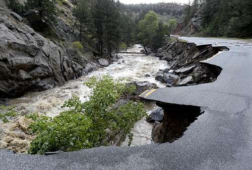
The route my navigation system had directed me to follow was northwest of Boulder along Lefthand Canyon Road. Upon my approach, and still while only a few minutes outside the city, I came to a road closure sign and a police car camped up next to it. I pulled up slowly and allowed the cop to ease out of his slumber, his eyes still bloodshot as he walked towards my idling rental car. We chatted for a few minutes, during which I told him of my plans to drive out to the Indian Peaks Wilderness (IPW) area to do some hiking and climbing. He informed me that the roads beyond this point were closed, as the sign adamantly suggested, but that residents living further down the road were permitted to pass. Although he didn’t appear to have firsthand knowledge as to the extent of the damage further thru the pass, he did say that the roads were “washed out”. Not knowing exactly what the term washed out meant, I didn’t think much of it and thanked the policeman as he let me pass to see “how far you can get”. I slowly drove upwards and into the unlit mountain pass, meandering through the canyon’s narrow roads while avoiding debris, such as fallen trees and boulders, and a few more road closure signs along the way. A few miles up I came upon the first of three “washout” areas I would encounter where large chunks of the road were savagely gnarled by the adjacently running river, two-thirds of the pavement gone with erratic-looking bite marks sunken in, rigid, dark and fallen into the sound of moving water below.
Just barely being able to ease past the damage raised my heart level considerably especially not knowing how stable the still standing platform of road would be. Nevertheless, I made it almost 10 miles into the canyon before reaching a section of road where there was no road; instead, just a void and absolute darkness below. It was now obvious I had to turn around.
![Lefthand Canyon Road Flood Damage]() Photo Courtesy of AP Photo/Daily Camera, Jeremy Papasso
Photo Courtesy of AP Photo/Daily Camera, Jeremy PapassoAn Alternate Golden Route
Upon my approach back to Boulder I realized I was lost. I made it to the city limits just fine, but the chances of me making it out to IPW and getting to climb now seemed futile. Complete dependence upon electronic navigation systems was my downfall. Although I had written down directions on a piece of paper via the Lefthand Canyon route, in full anticipation of losing phone reception once nestled in the mountain pass, this bit of information was no longer useful. Plus, every alternate route my Garmen navigation system and several iPhone navigation apps mapped out clearly identified road closures obstructing my way to IPW. The prospect of scrapping the whole trip crossed my mind, but the idea of doing so was a depressing alternative.
Just recently I had made the decision to indefinitely postpone my involvement in a team I had organized to
climb Denali in the Summer of 2014, which would have allotted me the opportunity to not only make an attempt at America’s tallest peak, but also to partake in training climbs on Rainier and possibly even others on challenging, winter descents out West. My decision to nix the Denali plan was based on changing life priorities and the subsequent financial burden revolving around becoming a husband, father and sole monetary provider for my family while living in Washington DC, which is an incredibly expensive place to live. Needless to say, while completely content with being a responsible husband and a newfound father, I still longed for a mountaineering excursion beyond the relative foothills of America’s East Coast. Thankfully, this trip to Colorado appeared to be just the opportunity I was looking for, but now, given the circumstances, little hope remained.
Although my level of optimism was low, my resolve remained strong, so I decided to start driving in a direction I had already gone and on roads I knew to be open. The alternate route took me on I-76 and back towards Golden. At some point, while still driving in complete darkness and without any sort of real plan, I glanced at the map on my navigation system and noticed what appeared to be a northbound road that would lead me to Peak-to-Peak Highway, which was the main artery allowing access to the easternmost approaches of IPW. A shimmer of hope glistened as I turned off I-76 and headed north.
The route proved to be fruitful as I navigated my way into the Brainard Lake recreation area and to Long Lake Trailhead, which was my original point of attack. The clock read five after 6AM, which was encouraging considering the circuitous route I had to take and since I had arrived less than two hours later than my intended arrival time. Based on the presumption that the Indian Peaks Traverse could be done in 10-12 hours, I figured I still had a shot at tackling my original itinerary and getting back for supper.
Long Lake Trailhead to Pawnee Pass
In order to improve my time and despite the flurries that began to fall, after parking the car I decided to lighten my pack by ditching a few extra layers of clothing and an extra liter of water I thought would be a luxury since once on the ridge, no source of water was available. I figured with the lightened load mixed with my commitment to take an absolute minimum number of breaks and my resolve to hoof it, I’d be able to move efficiently with haste and accomplish the entire route within 10 hours or less.
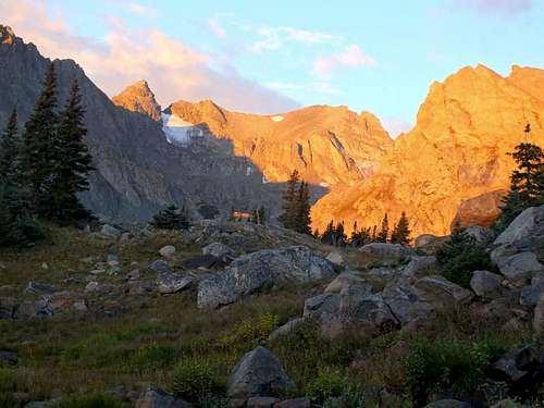
![Sunrise on Pawnee Pass Trail]() Sunrise illuminating (from left to right) Niwot Ridge, Navajo Peak, Apache Peak and Shoshoni Peak
Sunrise illuminating (from left to right) Niwot Ridge, Navajo Peak, Apache Peak and Shoshoni Peak The trail began at 10,500 feet and eased along without much variation in the elevation gained and lost. Through the darkness I hiked staring at the falling flurries accentuated by the light beaming onward through my headlamp as I gradually passed Long Lake and diverted to the Pawnee Pass trail. Nearly an hour and a half into my hike and about halfway between the end of Long Lake and the beginning of Lake Isabelle, I stopped and took my first break, which lasted only a minute, so I could remove a layer of clothing since the temperature had warmed up and to snap a photo of the morning sunlight majestically illuminating a portion of the mountain ridge I planned on traversing later that day.
![Switchback on Pawnee Pass Trail]() Switchback along Pawnee Pass Trail
Switchback along Pawnee Pass TrailAs the sun rose and its warmth poured down upon me and onto the exposed dirt and rock, I reveled in my moment of solitude. Hiking (alone) in “big” wilderness and mountain passes is therapeutic and is always a staunch reminder of genuine humility in the shadows cast by nature. The hike thus far had led me on scenic yet relatively uneventful Class 2 terrain. Then at about the midway point of Lake Isabelle at about 11,000 feet, the trail steepened considerably and headed north along a series of switchbacks towards Pawnee Pass.
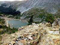
![Tree Impeded View of Lake Isabelle]() Gazing down on Lake Isabelle
Gazing down on Lake Isabelle
The switchbacks were moderate in steepness, which allowed me to maintain a relatively quick pace, and the rapid increase in elevation provided enough
prominence, in relation to the surrounding terrain, to get a more veritable perspective of the surrounding wilderness. As the trail ascended, the glacial lakes below began to shrink and the contours of the peaks above slowly became more defined, which allowed my mind to start dissecting prospective routes along their exposed ridges.
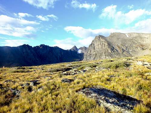
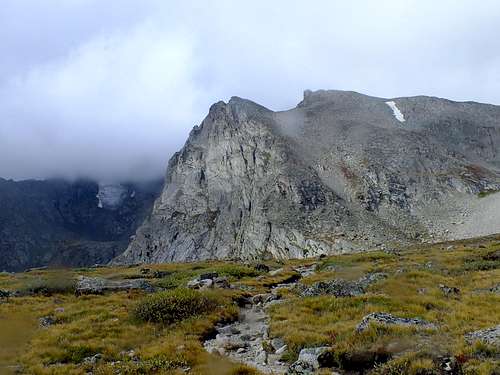
![Shoshoni Peak from Pawnee Pass Trail]() Sunny skies approaching Pawnee Pass and Shoshoni Peak and the beginning of the Indian Peaks Traverse
Sunny skies approaching Pawnee Pass and Shoshoni Peak and the beginning of the Indian Peaks TraverseAt about 12,400 feet, the final switchback ended and fed into an alpine plateau, clearly marked by trail and cairns, which rose another 150 feet in elevation to a wooden sign marking the intersection of Pawnee Pass and the Continental Divide. From here, I could see the northern peaks of IPW and the southern tip of the Colorado Rockies. The view was awesome, but the weather lurking over the terrain was alarming. Endless pillows of dark grey clouds layered the sky and appeared to be moving in on my location with ideas detrimental to my goal of completing an entire ridge traverse.
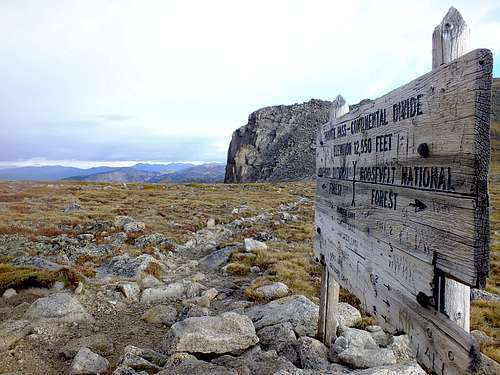
![Pawnee Pass - Continental Divide Sign]() Pawnee Pass - Continental Divide sign and a clear view of northern IPW, southern CO Rockies and inclement weather coming in
Pawnee Pass - Continental Divide sign and a clear view of northern IPW, southern CO Rockies and inclement weather coming inTo this point, once the sun had risen, the weather had been near perfect with relatively clear skies and a manageable, steady wind of no more than 15-20 miles per hour. Although mountain weather can vary rapidly, I had hoped the early morning weather would extend into a sunbathed afternoon and allow me to make a go at the not often attempted and highly exposed traverse along the ridgeline connecting Shoshoni Peak, Apache Peak, Navajo Peak, and Niwot Ridge.
Given the imminent and ominous weather rolling in and provided beta of Gerry Roach, an IPW expert and author of
Colorado’s Indian Peaks, who describes the traverse along the Continental Divide between Shoshoni and Apache Peak as “not practical”, my doubts of being able to realistically approach the traverse and get off the ridge safely began to rapidly deteriorate. Regardless, I remained optimistic and continued on as I cut off the Pawnee Pass trail and scrambled straight up the ridgeline and along the Continental Divide to a high point of 12,878 feet. While scrambling, I had to stop and pull out an extra layer of clothing to warm my torso and Goretex gloves to protect my hands from the sharp talus shifting below my hands and feet and also from the dipping temperatures as wind began to blast me in gusts of increasing intensity.
Scramble to Shoshoni Peak Summit
After achieving the ridge, I was situated at a point that runs along the top of the more gentle north slopes of Shoshoni Peak, but which also gives a clear vantage point of Apache Peak, Navajo Peak and Niwot Ridge. To my horror, the clouds had already begun to engulf the cliffs ahead as a wintery mix of snow and sleet pelted my body. Although already knowing the chances of ascending safely and further beyond this point where dismal, I marched on and upwards to the summit of Shoshoni Peak. As I sat on the summit and hunkered down for warmth, I gazed at the disappearing peaks in front of me in hopes that the clouds would soon break.
After ten minutes or so, the snow falling was heavier, visibility was near zero, and the wind was gusting at what I would estimate to be 40-50 miles per hour. With no let up in sight and the clock still ticking, I had no option; I had to turn around.
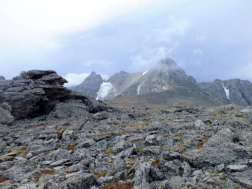
![Weather Moving in From Shoshoni Peak]() Clouds on Apache Peak summit from northern slope of Shoshoni Peak
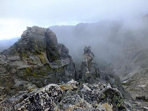
Clouds on Apache Peak summit from northern slope of Shoshoni Peak![Poor Weather on Shoshoni Peak Summit]() Summit of Shoshoni Peak and low visibility on ridge ahead
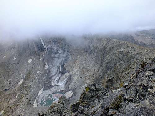
Summit of Shoshoni Peak and low visibility on ridge ahead![Bad Weather Near Shoshoni Peak Summit]() From Shoshoni Peak looking down on an unnamed glacial lake and zero visibility on the ridge
From Shoshoni Peak looking down on an unnamed glacial lake and zero visibility on the ridgeThe Right Decision
I quickly descended down to Pawnee Pass and back towards less exposed terrain. While heading back, there were a few moments where I second guessed my decision to turn around, but after glancing over my shoulder and up towards the ridgeline, my doubt subsided and confirmation of the right decision remained as the weather steadily grew worse and more hostile in the peaks above. Once I had descended far enough down and reached the shelter of wind-whipped trees, the snow turned into an on and off light rain and the wind was back to normal. I took my time at this point, knowing that the rest of my hike would be my last in an area like this for quite some time.
![Shoshoni Peak from Pawnee Pass Trail]() On the descent glancing back at Shoshoni Peak and worsening weather on ridge
On the descent glancing back at Shoshoni Peak and worsening weather on ridgeIn my trek back towards Long Lake Trailhead, I had time to recount the happenings of the day and contemplate the what ifs most climbers experience when not achieving their goal. Although I was bummed to have missed my opportunity to attempt the entire Indian Peaks Traverse, I was thankful to have even made it out to IPW given the difficulties I had ran into with road closures earlier that morning, which realistically dampered my confidence in making it out anywhere at all. I summitted Shoshoni Peak, which standing at 12,967 feet, is the highest point I’ve reached as of yet in a solo outing and is rewarding enough as a standalone highpoint for the day. In thinking about the timing of it all – if I had reached the trailhead at my originally desired start time, I probably would have been well on that ridge when the weather rolled-in without a route of retreat and without the visibility or previous experience to safely find my way out of it. Holistically, the experience hammered home the friendly and sometimes haunting reminder that nature always wins. Whether the diversion is caused by floods washing out roads leading up to the mountain pass or inclement weather amidst their summits, understanding that we as humans can only accomplish tasks in wilderness at the mercy of nature’s good graces, and not conquer nature itself, is an important lesson indeed.
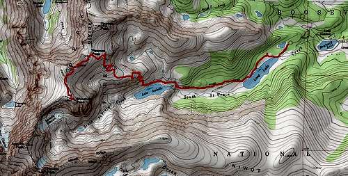
![Route from Long Lake Trailhead to Shoshoni Peak Summit]() Route from Long Lake Trailhead to Shoshoni Peak Summit
Route from Long Lake Trailhead to Shoshoni Peak Summit


Comments
Post a Comment