Finally
Like many others, I had hiked to the block Y on the mountain many times but I had never sought out the very top of this mountain, mainly because
I didn't seem to have the time to do so and would settle just for a quick up to the block Y and back for conditioning purposes. On my new job,in nearby Orem, I have tuesdays off and I had caught the weather report which said snow was expected by late afternoon in the local area so the light went on in my head. Y Mountain, I could squeeze that one in before the expected snowstorm hit.
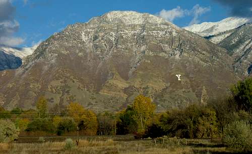
![Y Mountain from I-15]() Y Mountain (Rocky Alps pic)
Y Mountain (Rocky Alps pic)
I made it to the trail head for the "Y" early enough and was slightly surprised to find that my vehicle was the only one in the lot. Many people will make the drive up to the trailhead because there is a very nice view of the area from up there. I grabbed my daypack and camera and hit the trail. It is 1100 feet to the top of the block Y and it is from the top that the trail to the top of the main mountain begins. A nice
trail heads for Slide Canyon and the territory above. Besides Y Mountain, that trail will hook into ways to access Maple Mtn. or Provo Peak. I will save the hike up to Maple for another day since my focus was to get to the top of Y Mountain and get back down before the expected snow storm.
So finally, I was able to see what the view from the top of Y Mountain
looked like.
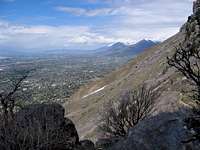
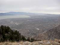
![From above the Y]() Looking back towards the Y
Looking back towards the YThe hike
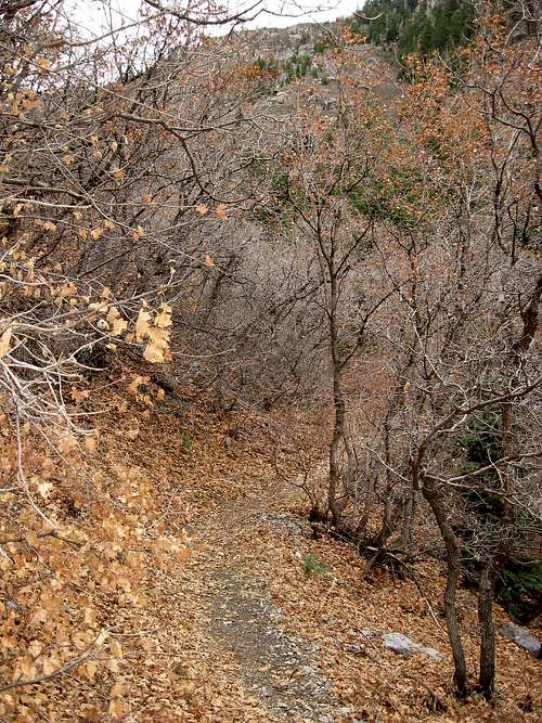
![The trail]() canyon trail
canyon trailA shot of what it looks like from the Slide The first part of the hike from the trailhead parking lot to the top of the Y covers about 1.25 miles and gains close to 1100 feet. At least that is what my GPS indicated. I took a few moments to enjoy the view from the top of the Y and grab a snack before I continued on up the trail into Slide Canyon. I found the trail to be in excellent shape and it obviously gets a lot of use. Perhaps fall might be the best time to do this hike particularly when the fall colors are in full splendor. I was a bit late for that but I could see the potential.
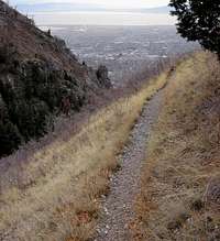
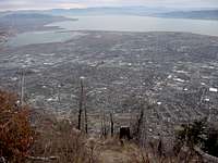
The trail works its way up slide canyon with a few switchbacks and some enjoyable sections that give nice views back down the canyon itself, always with a view of the suburbs and Utah Lake beyond.
![The trail]()
I found the trail to be one I really enjoyed and that aspect alone made it go faster. A small meadow was passed that had a decent campsite off to the right and not far beyond that was the fork described by Rocky Alps on the Y Mountain SP page. The left fork takes you right up a drainage but despite the steepness in places, it does its job admirably. In fact, this might be the most enjoyable part of the trail as it has a certain feel to it that you are definitely hiking up to someplace special. It finally tops out in a meadow between the two summit areas and the key is to stay on the trail to the northern aspect of the meadow, a place with some bizarre looking Aspen trees. The trail will then swing west and up to the ridgeline and the summit of the western peak that gives you the great views. I found no cairn or benchmark at the highest area but I did note several spots where campfires had been utilized as it was obvious that other folks have camped on the very top of the area. You will enjoy the views down into Provo and beyond as it is a spectacular viewpoint.
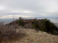
After spending some time snapping pictures and eating a few snacks, I headed back down to the meadow between the two summit areas and had to leave the trail to access the eastern summit, higher than the western one by about 50 feet. It was easy enough to just make my way up to the summit area, a matter of gaining about 200 vertical feet as there were enough game trails to ease the way up. At the top I found a cairn with a pipe in the middle of it. When I checked the pipe I found that it was cemented in place. No register or benchmark was located but I enjoyed the views despite the deteriorating weather that had been predicted was beginning to show itself. I cut my visit short and tarried only a few moments to snap a few picture (all of which came out on the dark side). I was thankful for my warm clothing and particularly the gloves I had on. The wind was beginning to bite as the temperature really began to drop. A few snowflakes pelted me as I started down and I felt my timing had been close to perfect.
![From the true summit]()
I saw no sign of the cougar that someone else had mentioned to me a week earlier that had been spotted in this area and when I hike by myself in country like this, I always try to keep a wary eye out, particularly in places where the trail passes under spots where a cougar could hide. No, not the BYU kind of cougar, I'm talking about the real thing. That cougar is probably long gone but then again, one never knows. The trip back to my vehicle went great, I covered the four miles in about an hour and a half
and it had taken me twice that time to gain the summit.
I will more than likely be back on that trail again when I go after the summit of Maple Peak.
The ending
This story isn't really over as I need to make the hike up there again only during different seasons. I would like to make a snowshoe visit of Y Mtn as well as nearby Maple Mtn.
Update: It did snow after I left the mountain and the next morning the surrounding mountains had a nice white dusting down to the 8000 foot level. Yet, it wasn't enough snow and more will be needed before I can do a nice snowshoe hike or get my skiis out. C'mon Utah, show me your famous snow. (Just kidding as I've already sampled all of the local ski areas in past years and the snow skiing is
excellent. My favorite ski area is Alta followed closely by Solitude.
Views from the east summit
While most people visit the top of the west summit for its excellent views, these two pics also show that views are to be had from the less visited east summit
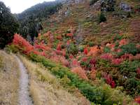
Fall colors
Rocky Alps has several nice pics showing the fall colors from a hike he made during a September. I include this shot to give you a flavor of the fall season on this hike.


Comments
Post a Comment