


Comments
No comments posted yet.
|
|
Trip Report |
|---|---|
|
|
42.11222°N / 80.15915°E |
|
|
Jul 31, 2018 |
|
|
Mountaineering |
After we failed to approach Peak Somoni from the east side - because the current of a river was too fast - we had to make a new plan.
I did a solo attempt of Pobeda (7439m) on the classic route in 2017. Due to a bad weather forecast i retreated from 6600m. This route is crazy. Dangerous in many sections - "You could die on every step" said somebody to me. Pobeda is said to be the most difficult 7000m Peak - at least for the Pamir/Tien-Shan region i'd confirm this.
This time (2018) i came with Simon Taffner. We called some agencies for organizing the helicopter transport to the basecamp at 4000m. But they told us that the helicopter had crashed some days before and they dont know if the can get another helicopter.
In the mean time we searched for a possibility to get acclimatised. Khan Tengri was not an option for me - i did it already in 2006 from the north side and i wouldn't take the risk to get avalached on the south route which is a little easier. All other mountains in the area are not easy to climb - lots of snow, steep faces, loose rock,... everything you don't want. Then we found a possibility to reach the plateau of the Ak-Tau group from the east side. Searching the internet gave nothing - we knew just what we could read out of the map and from satellite images.
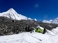
Luckily the could solve the problem and some days later we arrived on the glacier between Khan Tengri and Pobeda.
After 2 days in the basecamp we set off in the afternoon in direction of the first Khan Tengri camp but kept on the south bank of the glacier and set camp there.
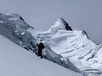
On the second day we saw a possibility to climb the ridge east of the plateau - so we changed the original plan to do a north-south traverse including the summit of Majlina 5285m.
Until the start of the ridge the glacier was only partly covered with snow.
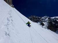
In the beginning the snow was not too bad. But the face got steeper and steeper and the snow deeper. I was curous where we would be able to find a place for the tent.
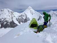
Just before sunset we arrived at a slightly flatter spot. With some afford of rearranging snow we could build a platform for the night.
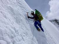
The next day was even worse. Bad weather, the face even steeper and lots of snow. One time Simon had to get out the shovel to dig through a cornice of rotten snow.
After a long day we made camp on a flat shoulder and took a whole sunny rest day.
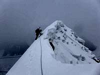
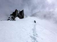
Climbing the narrow ridge directly looked scary. One side dropping to a steep face and a huge cornice to the other. We decided to traverse on the west flank a wall of snow covered ice where it was possible to use ice screws and topped out still one small summit before Majlina.
Plodding through deep snow again and traversing a exposed ridge finished us up and we pitched the tent directly on the summit of Majlina.
Walking down from Majlina was rather easy. Just a few spots where the way was not obvious.
In the saddle we had to make the decision if we continue for Ak-Tau or head down to the east - the route we had originally planned for the ascent - and return to basecamp. We chose Ak-Tau.
From Majlina i already had a look on the glacier and was trying to spot a path through the crevasses. The most eastern part of the glacier could have a passage. Two hours later we had managed to cross the problematic section and followed the long flat field which steepens up to the col between Ak-Tau and Pyramid.
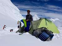
Just before dark we had our camp set.
A morning with almost blue sky but strong wind changed soon to a foggy day but as we run out of food and gas we headed for the summit of Ak-Tau.
In the beginning we used a rope because of crevasses.
The first part was a 40° snow field. The higher we climbed the deeper the snow. The upper part was a lot steeper and i had the feeling of swimming the snow upwards. Exhausting. Surrounded from clouds we finally reached the summit.
2 days of food and gas left. Not enough to stay another day and climb Pyramida.
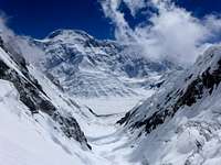
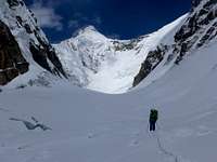
Our decision was to go down the couloir and glacier to the south. A little risky because the lower part looked very crevassedand that could mean to run into major difficulties or even to get stucked. To go down this valley would help us to see our next target and its approach closer.
First we did absail and downclimb in turns the steep face below the col (~55°). Then followed a easy flat glacier in a great scenery of mountains with Pobeda in front of us until we arrived at the crevassed zone.
For hours we had to search our way thought the labyrinth of crevasses, jump over several of those, closs fragile bridges and downclimb some steep sections. A big adventure, sometimes really scary. We needed another camp before we could reach the big valley at the foot of Pobeda and return to basecamp.
Markus Gschwendt, 2018
American Alpine Journal 2019, Online Version, Ak-Tau Traverse