See
Part 1. Maja e Korabit/Golem Korab.
‘Sempre sinistra’
July 25
Our next goal was Đeravica, the highest peak of eastern Prokletije. Passing Prizren and Đakovica we drove to Dečani, we wanted to visit the famous Orthodox monastery Visoki Dečani. According to our maps it was on the way to a village of Kožnjar a.k.a. Belaje where we planned to start the mountain trip. We reached Dečani well after dark, one of the locals showed us the further way. We left the town, tarmac was soon replaced by a dirt road, we passed some military buildings and a pack of barking dogs. Another two forks in the road led us to a gate guarded by Italian soldiers. I asked them about the monastery and Kožnjar but from their answer could only make out ‘sempre sinistra’ – always left. That meant coming back to our starting point. So we returned to Dečani to ask some locals again. Our Serbian was bad enough for us to be treated friendly, we could expect the native-like command might have caused some hostility in this Albanian-dominated area. The directions we got were sometimes opposite to one another, they only agreed that we had to go through the Italian military post. It finally turned out we should turn right at the first fork, the option we had first rejected because of the obvious ‘no entry’ sign. Looking from the other side, ‘sempre sinistra’ indeed. A short piece of potholed tarmac brought us to a highly fortified post. The road was closed for the night. We could hardly understand the heavily gesturing soldier, he was kind of showing us some way round. We understood it was the road we tried at the beginning but we could not guarantee the precision of this information. I thought soldiers take some classes of English or the local language before going to a foreign peace mission. Those guys, however, relied on their ability to communicate with the rest of the world in Italian with a little help of their hands.
The now familiar dogs barked at us again, we passed that first military post, the dirt road was getting worse. It was about midnight, we knew we would not reach Kožnjar that day and had to find a place to kip down. The road widened, there was some fenced water installation by its side. No dogs followed us. The place looked good and had a nice view at the lights of Dečani. We grabbed some grub and went to sleep rough on the grass.
Barriers and landmines
July 26
After an early breakfast we went further down the dirt road, passing the ruins of some Yugoslav holiday centre in the forest. Half a mile or so behind it we encountered barbed wire barriers, partly put aside so it was possible to walk but not drive through, but it would not be a problem to remove them completely. We left the car, walked on round the corner and met lots of Italian soldiers and army vehicles. Across the road was Visoki Dečani monastery. We showed our passports to nearest soldiers and tried to explain we wanted to see the monastery and go to the mountains and ask if we can drive through the barriers. The soldiers were slowly getting desperate, finally one of them made a call. Several minutes later an interpreter came by car. He said there would be no problem with doing what we wanted. We would just have to drive round back to that post that was closed for the night, instead of coming in here and maybe going to the post the easier way. David was a tad pissed off about the perspective of another 10 miles of bumpy dirt road and tried to negotiate if we could just put the barriers aside and drive through. That would be the obvious solution. But in all armies of the world the laws of physics are somewhat different. There is no point trying to understand them, we have to take them as they are, kinda like the Einstein’s theory of relativity. In Polish-Czech, so the soldiers could not understand, I told David to chill out, I was well chuffed we made it at all.
When we arrived at the checkpoint, they already knew about us, but our passports were thoroughly checked again. Escorted by a Land Rover we drove to the monastery, parked and went inside. A vast number of medieval frescos was quite impressive. We met a group of photographers documenting the Serbian heritage and places of interest in Kosovo, led by a Serbian-American married couple. The pictures can be seen at
their organisation’s website. The American woman told us about the fortunes of war at the monastery, which is an important place of worship for Orthodox Serbs. We never know what would be the monastery’s fate if not the Italian troops protecting it on behalf of the UN peace mission. In Yugoslav conflicts there are no simple truths or easy divisions into the good and the bad. Albanian Kosovar extremists were not better than the Milošević’s thugs. Those who suffered and still suffer most are ordinary people of all nations involved.
* * *
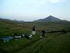
We drove up a good dirt road up the stream towards Kožnjar. We found a place by the stream and took a long-awaited bath, washing away all the previous days’ dirt in cold water. We reached the village just before 3pm. The only building by the main road was the carpenters’ workshop. We talked to some local guys, gave them a few packs of fags. They promised to keep an eye on the car. One said something about landmines up there in the mountains. We promised ourselves to stick to the paths. Easier said that done. We walked up the road for another hour or so, crossed the stream using the logs of an unfinished bridge. Another two hours up a very bad forest road and we reached a large meadow called Rupa (the hole). According to the old Czech guidebook that remembered the times of Yugoslavia, we were supposed to turn left somewhere there into a steep path up the forest. Towards the upper end of the meadow there was a place in the forest that looked run down by the woodcutters’ vehicles. Up from there we found the first red mark on a tree. Indeed there was a hardly visible, often disappearing path climbing the steep slope that eventually brought us above the treeline into the meadows.
![before Deravica]()
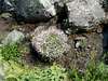
At the nearby saddle called Pločice there used to be a large mountain hut. Either we must have taken some other path or all that was left of it was some low remnants of walls and a settlement of shepherds’ sheds. We did not go down there, turning left instead.
![Plocice]()
Just before dusk we put up the tent on a flat meadow. Before we went to sleep, we drank a concoction of some sort of thyme and some other herb, brewed in boiling water by Ivoš and David.
‘Planinari’
July 27
![Deravica sunrise]()
![Getting up for Djeravica]()
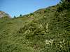
We woke up before sunrise and set off shortly after. When we crossed the first ridge, the peak of Đeravica presented itself to us for the first time. Despite the early hour it was already scorching and flies were swarming around us.
![Deravica up 1]()
![Deravica up 2]()
At 8.30am we reached the highest summit of Kosovo and Serbia.
![Deravica summit]()
We spent a long time resting on the peak. At last I caught a signal on my mobile so I could text my girlfriend. We had great views on the mountains around, including western Prokletije, our next goal. I found a couple of shells and beer caps. Someone must have had a shooting and drinking spree on the top. One of the boulders had UCK (Kosovar Liberation Army) written on it.
![Deravica view 1]()
![Deravica view 2]()
![Deravica view 3]()
We went down the other side, joining our yesterday’s trail later on. Ivoš, a keen botanist, was making notes of the encountered flowers every now and then.
![Gentiana]()
![Island in the stream]()
![Verbascum (mullein)]()
The sky was becoming overcast and we heard some distant thunders. We quickly ran down our forest path. The rain caught us when we were down in the valley but it did not last for long. Exactly 24 hours after leaving Kožnjar we were back there. After a bit of a chinwag with the locals we drove off down the valley, not forgetting to bathe in the stream on the way.
* * *
We planned to get to Montenegro by the scenic road via the 1849 pass and the Čakor village.
We left the town of Peć and entered the beautiful gorge. Behind it we followed an Albanian road sign for Čakor and went into a forest dirt road. Soon there was a sign ‘You are entering Republic of Montenegro, KFOR vehicles must return here’. We had never volunteered for KFOR so we decided to go ahead. Some half a mile further there was a huge pile of wood laid across the road. Apparently someone included us into KFOR and made us return.
The only place where we could have missed the turn was a sign showing some restaurant. So we turned back there, at that fork we met some local driver. Asked if that was the road to Čakor, he said yes. A good but very steep dirt road indeed led us to a restaurant but it seemed to go nowhere further. The owner told us the Čakor road was the one we followed first but it had been closed by KFOR several years ago. I thought another couple years would pass before some information signs are put, or perhaps the road would be sooner reopened.
On the way back to Peć we thought we could stop and see the Patrijaršija monastery. It was guarded by a KFOR post, for the same reason as the Visoki Dečani monastery was. A soldier – what a surprise – spoke good English. He checked our passports and wanted to make sure we were not Muslims. Two fair-haired Czechs must have looked like ones. A bloke with a Polish passport and slightly darker hair perhaps even more. He phoned the monastery but unfortunately was told it was open only till 5pm. It was already after 7 so he invited us for the next day. Not having that much time we regretfully took a rain check.
The only option left was to reach Montenegro via the 1710 pass, Rožaje and Berane. Good asphalt road up the long hill, Kosovar border post, further 2 km and we came to the Montenegrin barrier. A very big, tall, good-humoured officer came up and asked where from and where to we were going. ‘From Korab and Đeravica’ – I said. ‘
Planinari!’ (mountaineers) – he exclaimed – ‘I’m a mountaineer too, I like all mountaineers!’ We had agreed before with David and Ivoš on our legend from that moment on – we were officially heading for
Durmitor, as the name Prokletije might have raised a slight suspicion of our intentions to cross the Albanian border. Over-cautious perhaps but better safe than sorry. So I told the guy we were going for some hiking in Durmitor, driving via Gusinje. ‘Gusinje?’ – he interrupted again – ‘To Prokletije? I’ve been there!
Maja Karanfil?’ – he asked with a broad smile on his face. ‘Maybe, if time allows’ – I said, smiling back.
A few kilometres later we stopped to kip down in the forest.
See
Part 3. Maja Jezerce.
Comments
No comments posted yet.