
-
 12710 Hits
-
 86.85% Score
-
 23 Votes
|
|
Route |
|---|---|
|
|
46.06277°N / 7.86389°E |
|
|
Mountaineering, Ice Climbing, Skiing |
|
|
Spring, Summer, Winter |
|
|
Most of a day |
|
|
Alpine F+ |
|
|
Overview
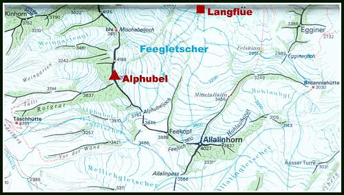
Geographical classification: Western Alps > Pennine Alps > Mischabel Group > Alphubel > Alphubel East Flank Normal Route from Längflue
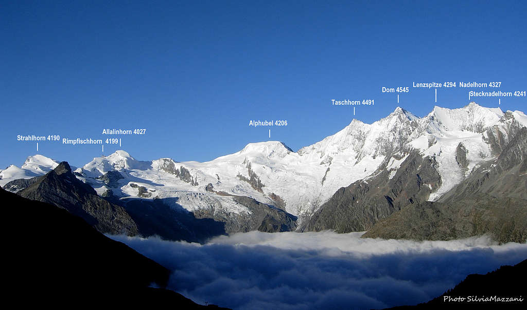
Alphubel East Flank Normal Route from Längflue
With a difference of level of 1330 meters from Längflue and a distance of about 4 km., the East side normal route is a very popular route, the easiest one to get the summit of Alphubel, a large and massive icy peak belonging to the golden circus of Mischabel Group in Wallis (Swiss Alps). This superb 4000 m. peak lies in a majestic icy setting between the Alphubeljoch and the Mischabeljoch and has the shape of a regular trapezium, culminating with a boundless icy plateau. Although fairly easy, this route requires a good alpine experience, developing itself on the mighty and crevassed icy basin of Feegletscher, and involves a complete glacier equipment. The route is usually climbed also by the sky-mountaineers in late winter and spring. Breathtaking summit views over the Mischabel Group, Monte Rosa Group and Matterhorn.
History
Alphubel First summiters : T.H. Hinchliff and Leslie Stephen with the guides Melchior Anderegg and Peter Parren (August, 9th 1860)
First summiters of East Side route: unknown
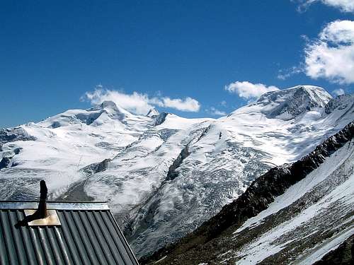
Allalinhorn and Alphubel from Mischabel Hut |
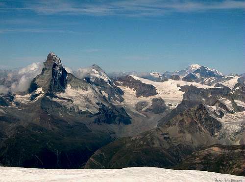
Cervino, Dent d'Herens and Monte Bianco from Alphubel summit plateau |
The starting point is the famous ski and mountaineering station of Saas Fee m. 1803, situated in Saastal. - From the town of Visp in Rhone Valley (Wallis) take the Vispertal and follow it to Stalden m. 799. Pass Stalden and get a road junction. Turn to left, entering the Saastal and getting Saas Balen m. 1483 and Saas Grund m. 1559. On the right follow a road getting within 4 km. to the nice village of Saas Fee m. 1803 (30 km. from Visp).
Approach to Längflue
There are two different ways:
- By walking (3,30 hours from the village). From the church of Sass Fee m. 1772 a narrow road leads to Hinter den Zäunen; from here cross the river and through the wood get a small lake m. 1904, just beneath the huge moraine of Feegletscher. The good path rises up the moraine getting to Spielboden m. 2447, the middle station of the cable-car. Up the rocky slopes of Längflue to the hut.
- By cable cars from Saas Fee to Längflue. Cross the village towards South for about 1 km. from the car-park getting the hamlet of Kalbermatten. Starting point of the cable-car. The first section leads to the Spielboden middle Station 2448 m. From here take the second section to the upper station close to the hut.
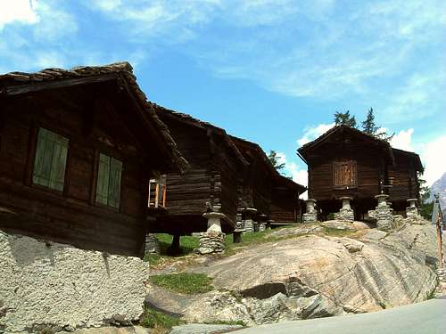
Traditional Walser houses in Saas Fee |
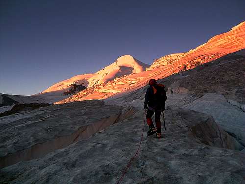
First steps on Feegletscher |
Summit altitude: m. 4206
Difficulty: Alpine F+, 35° on ice
Climbing length: 1336 m.
Exposure: East
Starting point: Sass Fee m. 1734
Hut: Längflue Hut m. 2870
A wonderful ascent climbing one of the greatest 4000s of the Wallis. The only problem is represented by the huge crevasses on the Feegletscher and in case of bad weather by the mist along the upper section of the route. Due to the presence of several crevasses, especially in the part between 3200 and 3600 m. of altitude, the glacier mustn’t to be taken lightly, although the way is often well traced.
First gently angled snow-slopes |
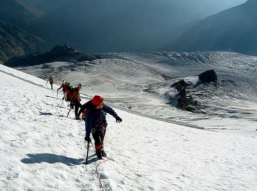
A party along the Normal Route |
Route report
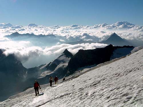
From Längflue Hut follow towards SSW a short trail with several cairns, getting soon the rough surface of the Feegletscher. Begin to cross straightforward the glacier towards SSW (towards Albhubelhjoch), rising on gently angled slopes. Pass to the right the rocky islet at 3174 meters of altitude, then gradually head to right. Once getting to the height of 3600 m., definitely turn to right, climbing snow-slopes for a long time, reaching finally the bergschrund. After the crossing the slope becomes steeper (35°-40°), shaping the characteristic concavity of East Face. Climb it (directly or with various diagonals), getting to the vaste icy plateau (from 4 to 5 hours from Längflue). Follows the ridge to the right to reach the highest point of this great mountain, dominated by a large wooden cross. The views are truly superb and boundless!
Descent: following the same route
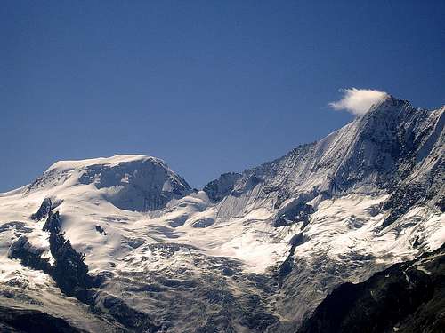
Alphubel trapezium and Taschhorn |
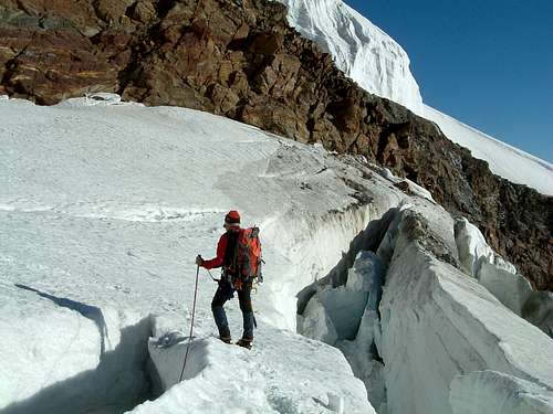
Ice-bridge on Feegletscher |
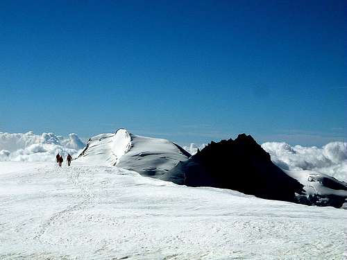
Parties on the summit plateau |
Essential Gear
Rope, ice-axe, crampons, ice-boots, high mountain clothes
Huts
Längflue Hut 2870 m– Property of Sass Fee Municipality, 80 beds
Phone 0041-27-9572132
The shelter lies on Längflue rocky spur, isolated in the middle of the wide and very rough surface of Feegletscher
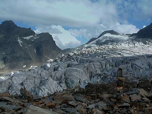
Seracs near Längflue
When to climb
Mountaineering: usually the best period goes from the middle of June to the middle of September, with the notice that in late summer the glacier is highly crevassed. Ski-Mountaineering: from March to MayRed Tape
Car are not allowed in Sass Fee and must be left in the paying car-park at the entrance of the village. No others particular restrictions in mountaineering, climbing and hiking.Meteo
METEOSWITZERLANDGuidebooks and Maps
- "Il grande libro dei 4000 - Vie normali e classiche" by Marco Romelli, Valentino Cividini - Idea Montagna Editore, 2015
- "Tutti i 4000” – L’aria sottile dell’alta quota" - CLUB 4000 CAI TORINO – Vivalda Editori
- "The 4000 of the Alps" by Richard Goedeke (CAAI) – All the normal routes to the 4000m. summits of the Alps – Libris Edition.
- "Monte Rosa" by Gino Buscaini - Collana Guide dei Monti d'Italia CAI-TCI (Club Alpino Italiano-Touring Club Italiano)
- "I Quattromila delle Alpi" by Karl Blodig and Helmut Dumler – Zanichelli Editore
- "Walliser Alpen, Vol. 5: vom Strahlhorn zum Simplon" - Verlag Swiss Alpine Club (German or French)
- "Ski alpin, vol. 3: Alpes Valaisannes" - Verlag Swiss Alpine Club.
 |
 |
 |
 |
 |
- "Randa" n. 1238 - 1:25.000
- "Matterhorn-Mischabel" n. 5006 - 1:50.000
- "Mischabel" n. 5006S (with ski-routes and difficulties) - 1:50.000.