

Mathias Zehring - Oct 20, 2004 6:08 pm - Voted 10/10
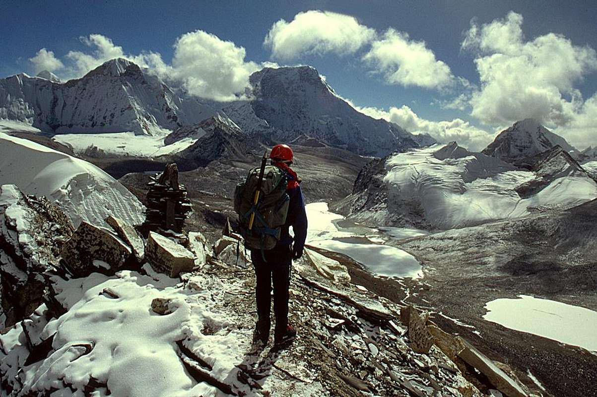
question!very beautiful picture (I have similar ones from one year ago). but I have a question: do you know the name of the peak left of Chamlang? I've read the name somewhere, it was a "peak Nr. ??", but I don't find my source now.

Nelson - Oct 20, 2004 10:17 pm - Hasn't voted
Re: answer?Mathias, you ask a good question. Last year I had scanned and posted a shot of that peak and called it Peak 6480, based on looking at a trekking map. I just looked at five maps and decided that the Schneider Khumbu Himal map has it as Peak 6770. (That link is an improved new scan, I deleted the old one).
If you have the Schneider map follow the ridge heading south from West Col. In the above picture West Col is just off the left edge of the photo.
But I could be wrong, it may be some other peak. Whatever, it's a beauty!
Mathias Zehring - Oct 21, 2004 1:03 am - Voted 10/10
Re: answer?you are certainly right with the position! Now I searched a bit in the net and found this picture. Therefore the name is "Chonku Chuli"
Nelson - Oct 21, 2004 8:52 am - Hasn't voted
Re: answer - maybe?Mathias, I had done that web search and found the same picture. I had heard of this peak called "Pyramid Peak" before, but none of my maps has it labeled as such. However, I do have a map that labels "Chonku Chuli" over on the east side of Sherpani Col, not south of West Col. And, when we were in the Barun Valley we looked at peak that the Sherpas called "Chonku Chuli". It is shown as Peak 6830 on the Schneider map, and may be the right hand peak in this photo..
It turns out both of these peaks (6770 and 6830) are connected by a complex ridge system that is clearly visible in this satellite photo. If you want I can edit it, add a couple of lables, and send it to you in an E-mail.
This is one thing I love about this area: the geography is so complicated and there are so many peaks that is often hard to tell what the heck you are looking at!
Mathias Zehring - Oct 21, 2004 3:56 pm - Voted 10/10
Re: answer - maybe?Interesting topic! In fact, P. 6830 is named in one of my books (Toru Nakano, Trekking in Nepal) as „pyramid peak“. Of course, somehow each mountain can be named as a sort of “pyramid peak”. P. 6830 is the peak just in front of Makalu when seen from Mera Peak.
Thank you for your offer. I’d like to look at the good resolution satellite picture! But the picture here at SP is clear enough that the position of the mountains can be recognized well.
It seems to me as if there don’t exist real names as no people live in this area. Even some maps are wrong – so it is not sure that your map names the right mountain! (for example here pyramid peak has a height of unbelievable 7123 m!)
When we walked down Hongu valley I surely asked our sherpas about the name, but unfortunately I don’t remember the answer.
Nelson - Oct 21, 2004 6:32 pm - Hasn't voted
Re: answer?This is interesting. Many of the peaks in the Barun on the way to Makalu are called just by numbers: Peaks 3, 4, and 6 are ones I photographed. Anywhere else these things would have a major National Park named after them!
To wrap up, in your excellent photo taken from Mera, Peak 6830 (aka Pyramid Peak, aka Chonku Chuli) is on the right in front of Makalu. At the far left is Peak 6770, the one that started this whole discussion. That connecting ridge is clearly visible in the satellite photo, which I think you have already located. I'll E-mail you the full picture that I downloaded from the Nasa site later tonight or tomorrow morning.

Damien Gildea - Sep 3, 2008 6:49 pm - Hasn't voted
Re: answer?Just to clarify, 6770 is Hongu Chuli (Chong/ku etc).
The peak visible in Mathias's shot (with Makalu behind) is 6830 aka 'Pyramid Peak'. Hongu Chuli is out of pic left and closer to the camera.
So, on a map, Pyramid is NE of Chamlang, whereas Hongu is due N.
Peak 6 is also called Tutse and has had no official ascent, but probably some unofficial climbs from Makalu teams. Peak 3 was climbed in 1992 or thereabouts, by Brits.
D
Nelson - Sep 4, 2008 11:33 am - Hasn't voted
Re: answer?Thanks for the clarification Damien. How did you manage to dredge up this old discussion?! I think I've had occasion in the past to remark to you that seen one damn Himalayan peak, seen 'em all. :)
In other words, I was wrong about Peak 6770 being in Mathias's photo. But my label on this photo is correct: it is Peak 6770, aka Hongu Chuli.
What map(s) or other references are you using. Just curious - is it something new I should get a copy of?
Thanks. Nelson
Damien Gildea - Sep 18, 2008 3:57 am - Hasn't voted
HonguHi Nelson,
Sorry for the delay, I only just saw this. Yes, that pic you link above is Hongu Chhuli, more from the NE.
I was thinking of going there in Oct/Nov, as I won't be going to Antarctica this season, but I'm also busy writing a new book so I may not have time. Still enjoying your photos of the area though!
D
Damien Gildea - Sep 18, 2008 3:58 am - Hasn't voted
Maps... and I have the Washburn NG Everest map, plus a Chinese map and a couple of trekking maps. I've ordered the whole set of the newer Finnish maps, but they haven't arrived yet.
D
Nelson - Sep 19, 2008 1:25 am - Hasn't voted
Re: MapsThanks much for the replies Damien. Glad you enjoy the photos. Maybe I'll dig through my stuff and scan some mopre some day. You are absolutely correct that my photo is more from the NE, taken not far from the western base of West Col.
Good luck if you head into there, such a spectacular area. It still felt very wild the last time I was there in 2002.
I was going to order the Finnish maps a few years ago, but never followed through.
Take care, Nelson


Comments
Post a Comment