

|
|
Area/Range |
|---|---|
|
|
42.03581°N / 80.12938°E |
|
|
Hiking, Mountaineering, Ice Climbing, Mixed, Scrambling |
|
|
24406 ft / 7439 m |
|
|
Overview and Structure
The Tian Shan is a Central Asian mountain range located in Kyrgyzstan, Kazakhstan, Xinjiang (China) and Uzbekistan. It stetches 2800km from east to west and 350-400km north to south. Unknown to many this is actually wider AND longer than the Himalaya which is a mere 2400km in length and 250-300km in width. The Tian Shan contains more than thirty peaks close to, or over, 6000m including some of the highest in the former Soviet Union. It also contains some of the largest glaciers outside the Arctic poles. Compared to the likes of the Himalaya the range is also relatively unexplored - particularly by those outside the former Soviet Union block. The range is surrounded by huge arid flatlands. In the south is the Taklamakan, the world's second largest sand desert and in the north there's also a large desert area; the inhospitable wastelands of Gürbantüngüt/Junggar Pendi.
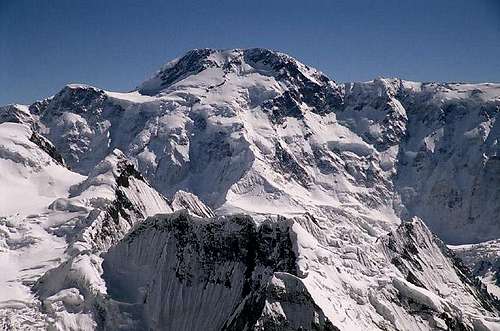
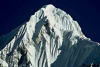
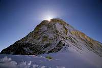
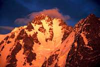
North Face of Pobeda, the highest Peak in the Tian Shan
The Tian Shan’s highest peaks are found at the heart of the Central Tian Shan where the Kyrgyz, Kazakh and Chinese borders meet (see coordinates). The highest is Pik Pobeda (Victory Peak), or Tomur Feng in Chinese on the Kyrgyz-Chinese border and is the second highest in the former USSR. At 7,439m it is also the highest point in Kyrgyzstan. A short distance north straddling the Kazakh-Kyrgyz border is the Tian Shan's second highest peak, Khan Tengri (Lord of the Spirits), at 7010m. These are the two most northerly 7000m peaks in the world and among the coldest due to their exposed northerly winds. This region is sometimes called Ha-Ke/Halke Shan in China. Between these two peaks flows the remote 62km long South Inylchek (or Elgilchek) glacier, the third largest glacier outside the polar regions. To reach the base of these two mountains takes days of trekking and nearly all expeditions arrive by chartered helicopters via Almaty or Bishkek. Many other parts of the Tian Shan are very accessable however with peaks in easy reach of Bishkek, Almaty and Urumqi.
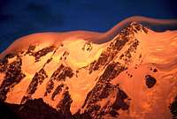
Bogda at sunset
East of Pobeda the Tian Shan extends beyond the border regions and into Northern Xinjiang and forms a large arrow pointing east. The northern leg of this arrow is pointing SE and consists of the Borohor Shan. The highest peaks in this sub range reach 5500m. The southern arrow leg is Tian Shan proper. East of Xinjiang’s capital Urumqi the range is known as Bogda Shan and considered part of the Tian Shan to Chinese. The massif is crowned by the 5448m Bogda Feng. Tian Shan terminates with the Karlik (sometimes called Barkol/Ba Kou Shan) range, which has peaks up to almost 4300m. Western cartographers, inlike the Cjines, consider this a range.

Horses in the central valley
West of the Pobeda-Khan Tengri region the range divides and follows both the Chinese-Kyrgyz border (Central Tian Shan) and the Kyrgyz-Kazakh border (Northern & Western Tian Shan). The former terminates at the Kunlun and Pamir ranges while the latter terminate in Uzbekistan. Between the Central Tian Shan and the Northern/Western Tian Shan and Borohor Shan sub ranges to the north are the broad, high grasslands that are the traditional home of the Kyrgyz and Kazakh people. If you're to believe the local nomads the beauty of this area gave the range its name.
The alpine peaks of the range is found right at the border of China and Kyrgyzstan and in the Bogda Shan. This is also where the most interesting climbing objectives are found. The central part of the range has lots of nice trekking areas and lower, usually not so technical mountains. In the extreme south, close to the Taklamakan desert there are some interesting rock climbing possibilities, for trad climbers only.
The first European to penetrate the range was Piotr Seminov, already a member of the Russian Geographic Society aged only twenty-two. In 1856 he made his first expedition to the Lake Issyk Kul region. The following summer Seminov, at the head of an army of 1500, crossed the Santas Pass and proceeded east towards the Chinese frontier arriving in the highest area in the entire range. Here he counted at least thirty high mountains the highest which he believed to be Khan Tengri.
Tian Shan or Tien Shan?
The mountain range is correctly spelt “Tian Shan” in China but sometimes “Tien Shan” in the Central Asia republics and Russia but ultimately both pronounced the same – “Tien Shan”, since the ”ian” in Chinese Pinyin is pronounced as “ien”. “Tien” is the older romanization of Chinese, which isn’t in general use anymore because it is confusing and Anglocentric. In the Uyghur language of Xinjiang the range is called Tangri Tagh. Both the Mandarin “Tian Shan” and Uyghur “Tangri Tagh” translate as “celestial mountains” or “mountains of the spirits”.
Getting There
International Flights
The main international gateway to Tian Shan in China is Beijing. Shanghai and Hong Kong are also options although are further away. There are also limited international flights to Urumqi (Ulumuqi in Han Chinese language) from Central Asia and Pakistan. Flights to the Central Asian block are generally more expensive but then are closer to the mountains than the Chinese gateways. The cheapest places to fly to are Almaty and Tashkent with Bishkek in third place. Compared to China there are fewer airlines that fly to this part of the world. There were amazingly no flights between Pakistan and Central Asia for example when I last checked in 2005.
Getting to the Tian Shan
From the East/mainland China

Mountain road in Tian Shan
China has a very good railway network and Urumqi is served by the main train line from Beijing via Xian. It's a long ride and the scenery is quite monotone, passing through flat, dry, hot and dusty semi-deserts. There are long distance buses as well, but the train is definitely preferable, unless you like crammed sleeper-buses full of chain smokers. The sleeper buses also haven't been designed to accommodate for people over 6 ft like myself!
China has a good network of internal flights with direct flights to Urumqi from major cities on the east coast and interior. Flying internally in China is an experience in itself and the cabin retains a definite holiday atmosphere in summer months. Once the seat belts light goes out you will be one of the few people sitting!Usually, you can pick up a ticket for Urumqi last minute in Beijing International Airport. In general, domestic tickets are easy to obtain at relatively short notice exception during public holidays when they are impossible. China Southern Airlines fly from major cities on the east coast and SW China to Xinjiang.
Reaching the Tian Shan from the North
Tashkent is the main gateway from Russia by train. The journey between Moscow and Tashkent takes three days. Only for people with more time than money!
Travel within the Tian Shan
China-Kazakhstan
The border at Korgas is infamous for corruption and hassles with corrupt officials on the Kazakh side. Personally, I had no problems whatsoever there and rumors say the situation has become much better the last couple of years. You can cross the border by train or with connecting buses. If choosing the latter, you have to take a ride with a minibus through the no-man's-land in between the two countries.
In China you'll end up in Yining/Ili. To continue straight into the Tian Shan you have to apply for an Aliens Travel Permit, as there are areas further east closed to foreigners.
It's not expensive and you can get it in a day in the local PSB (Public Security Bureau). This permit entitles you to through the areas and stop in certain places. Most major roads are well served with buses, but the railway only takes you in direction Urumqi.
Kazakhstan-Kyrgyzstan
Kyrgyz-Kazakh border crossings are hassle free and there are plenty of crossing points.
Kyrgyzstan-China
There's no border crossings open for third party travellers in between the countries. You either have to cross via Kazakhstan or cross far south at Torugurt Pass or Irkestam. See for example Pik Lenin page for details.
Red tape
Permits
China
Peaks below 6000 meters
Most peaks can be climbed without a permit.
Officially, you have to pay a $50 fee for climbing any peak below 6000m. In the Tian Shan this rule only applies on the peaks which are considered "mountains".
Does this sound strange and open for debate?
It is, but usually you only need a permit for the highest peaks in the Bogda Shan. If you go trekking and scramble or climb some minor peaks in the rest of the Tian Shan no one will probably bother you.
If in doubt - ask.
Peaks above 6000 meters
The authority to ask about the above and to get permits for the higher peaks is the CMA - Chinese Mountaineering Association.
Officially the price for the peaks in between 6000 and 7000m is $700 and for Tomur (Pik Pobeda), which is over 7000m it's $1080.
The price is based on a 12 person group.
Small nature preservation fees may be added in some areas.
China still have some areas which are closed to foreigners. If your climbing object is located in one of those, you also need something called an "Alien Travel Permit". It's easy to pick up at the local police station or you can let the CMA arrange it for you. The price varies a bit, but it's usually not more than $50.
Be careful with this in all Chinese Tian Shan and find out what the rules are before going there. No one will warn you and it's probable you travel around until you end up at a police barrier and then fined and kicked out of the area. Usually, the police put you on a bus to the next "open" city or area.
Traveling from China over the Torugurt Pass to Kyrgyzstan (or in the opposite direction) requires you to travel with a pre-arranged jeep on the Chinese side, with an governmentally acknowledged agency. Travel over the Irkeshtam Pass pass is possible by regular daily buses traveling to Osh.
Kyrgyzstan
No permits are currently required in climbing in Kyrgyzstan (the government abolished them a couple of years ago). Anyone who wants to visit the border areas of the Central Tian Shan however requiers a Propusk (this Russian term translates to Military Border Permit). The Propusk is available through Kirghiz travel agencies and will cost about 30 Euros.
Visas
Check the Lonely Planet Thorntree forum for latest info on visas as things are always changing.
Kyrgyzstan has dropped the visa requirement for many nationals and visas are available at the Manas international airport in Bishkek. Arriving overland, you still have to get a visa prior to arrival, but it’s easy to get from a Kyrgyz embassy and a letter of invitation is generally no longer required.
China visa procedures are nowadays very straight forward and you can pick up a visa in a 1-3 days in any Chinese embassy. Chinese embassies in Kazakhstan and Kyrgyzstan don't seem to have been informed that China aspires to be the biggest destination for tourism and still weren’t issuing visas without an invitation from a Xinjiang tourist agency such as ITMC or Celestial Mountains last I heard Invitations cost around $50. Tashkent, in contrast, is easy to get a visa if traveling through the Stans.
The Kyrgyz and Kazakh Chinese embassies weren’t issuing visas without an invitation from a Xinjiang tourist agency such as ITMC or Celestial Mountains. Invitations cost around $50. Only Tashkent easy place to get Chinese visa.
Uzbekistan's policy of handing out visas cqn be both time consuming and expensive, as well as unpredictable depending on your nationality. Some nationals have a hard time to get a visa at all. The good news it that things are getting easier. Around ten countries can now get visas without a letter of recommendation (Sweden unfortunately not one of them!). Sometimes a sponsor in the country is needed and the Uzbek representatives are usually trying to push you to buy a tour group deal.
Remember; the rules for getting a visa can be very different depending on which country you are from. A national from country X may get a free visa at the airport, but a person from country Z may have to apply months in advance and pay a lot of money for it.
Transit visas are usually quite easy to get. Extensions can be tricky and make sure you check out the rules about this before heading off for the mountains.
Embassy list
Kyrgyzstan
Uzbekistan
China
Kazakhstan
The Central Tian Shan
The Tian Shan reaches its zenith at Kyrgyzstan’s eastern border with China. These mountains are known as the Central Tian Shan but in lore known as Muztagh, or “ice mountain”. The Central Tian Shan is located south and east of Lake Issyk Kul and includes the sub-ranges of Terskey Alatau (Alatau means literally “colourful rocks” in Turkic), Sariddaz, Kuyliu, Tengri-Tag, Engilchek, Kokshaal-Tau and Meridionalniy Khrebit. In effect, it is synonymous with mountains.The region contains the range’s highest peaks and longest glaciers. At the heart of the Central Tian Shan are the majestic peaks of Khan Tengri (7010m) and Pik Pobeda (7439m).
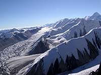
Flight to South Inylchek base camps
The Inylchek Glaciers
The Inylchek (or Engilchek) glacier has a Northern and Southern branch. The Southern Inylchek is the largest glacier of Tien-Shan and second largest among the CIS countries after the Fedchenko glacier in the Pamirs. Located between Tengry-Tag and Kokshaaltau ridges, it is 62km long and averages 2.2km in width. Starting in the Khan-Tengri area it flows westwards falling 2800m. The Inylchek River flows west into the Sarydzhaz river, where it turns south through deep canons and waters China’s Tarim Valley.
The glacier is the staging post for the Tian Shan's most popular climbs, namely Khan Tengri and Pik Pobeda. These are not the only peaks of note however. Neighboring Khan Tengri is Chapaeva, whose southern face remains unclimbed. Gorkova is another notable peak. Despite the glacier's grandeur, there are still peaks that have not been summited.
South of the South Inylcheck glacier is the Kokshaal-Too, which is the highest ridge in the Tian Shan. The ridge includes Pobeda, the highest in the Tian Shan, as well as Pogrebetskova (6527m), the Peak of Military Topographers (6873m),and Rapasova (22350ft).
 South Face of Chapaeva South Face of Chapaeva |
 South Face of Gorkiy Peak South Face of Gorkiy Peak |
The Northern Inylchek Glacier lies between the Tengry-Tag and the Saridjaz ridges. The glacier is also popular among mountaineers who come to climb the northern routes on Khan Tengri as well as the Marble wall and Chapaeva. At the western extreme of the glacier is the Merzbacher Lake for which I shall add information on soon.
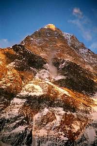
Pik Pobeda / Mount Tomur
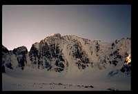
Set amidst the Kokshaal-Tau (Forbidding Mountains) chain, Peak Pobeda is the highest mountain in the Tian Shan and the second most northern peak in the world over 7000m after Khan Tengri. The weather conditions during climbs are extremely rough. The rare days with good weather are separated by long periods of bad weather in which the icy wind from the Taklamakan often buffets the mountain, making it impossible to climb.
Pobeda first climbed in 1956, by an expedition headed by V. Abalakov. The summit was reached after 30-days. He named the mountain ‘Pobeda’ which means ‘victory’ in Russian and referred to the Red Army's Second World War triumph against the Nazis. The classic Russian 5B Medzmarishvili route is extremely tough with a twelve kilometer traverse above 7000m to reach the summit. The oute is less direct than Abalakov's line however generally considered to be safer. Khan Tengri is usually climbed first for acclimatisation. To reach the main ridge is also very dangerous with numerous avalanches crashing down Pobeda’s northern face. Compared to Khan Tengri Pobeda’s summit receives a fraction of the number of climbers.
 Sunset over Pobeda as viewed from Khan Tengri Sunset over Pobeda as viewed from Khan Tengri |
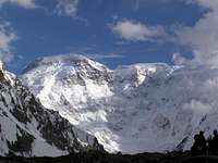 Pobeda's north face from base camp Pobeda's north face from base camp |
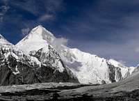
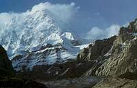
Khan Tengri
Khan Tengri is one of the most beautiful mountains in the world, its prominent ridges forming an almost perfect pyramid. It was thought to be the highest mountain in the Tian Shan until the 1930s before Pobeda gained the title. Relatively recently the peak’s height was increased from 6995m to 7010m. Many ‘Snow Leopards’, climbers who have summited all the former USSRs 7000m peaks, now had one more to bag to regain their title!
Khan Tengri was first climbed by a Ukranian called M. Pogrebetskiy in 1931. His route (Russian 5a) from the south involved relatively easy snow slopes up the Semenovskogo glacier to a col at 6000m followed by a mixed 1000m+ western ridge to the summit. His route is the classic route today. It is not without danger however. Conditions on the mountain can be severe with freezing temperatures and strong winds. The Western ridge is particularly exposed to northern winds that can be violent when weather is bad. The neighboring pik Chapaev also has a reputation for dropping sections of its huge cornice on to the classic route below.
The mountain is also regularly climbed from the Kazakh side to the north. The classic route (Russian 5a) also climbs to the col at 6000m then follows the Western ridge o the summit. Despite being the same grade as as the Pogrebetskiy route this route is slightly harder however many tour operators prefer to climb from the north feeling that Kazakhstan is more politically stable than Kyrgyzstan. There are also a number of super hardcore Russian 6B routes direct up the 2000m face.
 Khan Tengri from the South Inylchek Glacier Khan Tengri from the South Inylchek Glacier |
 North Face of Khan Tengri North Face of Khan Tengri |
 West Ridge of Khan Tengri West Ridge of Khan Tengri |
The Terskey Alatau
This sub range of the Central Tian is located south of Lake Issyk Kul and can easily be accessed from the small town of Karakol. Peaks such as Djigit (5170m) and Karacolskly (5281m) have a good range of routes of different grades. The region as a whole is an Alpine wonderland with dense conifer forests and broad meadows and excellent for short treks. The Djeti-Oguz valley, popular with locals in the summer months, also has some beautiful red sandstone rock faces.
 The Karakol Valley The Karakol Valley |
 Ala Col Lake Ala Col Lake |
 The Red cliffs of the Jeti Öghüz valley The Red cliffs of the Jeti Öghüz valley |
The Bayancol Valley
This is located in the South-west corner of Kazakhstan close to the border of China and is one of the largest valleys in the Tian Shan. It is rarely visited despite many of the peaks being relatively easy. Peaks include Kazakhstan (574m), Bayancol (5841m), Semionova (5816m), Karli-Tau (5450m), Pogranichnik (5258m) and the stunning Mramornaya Stena (Marble Wall) (6400m).
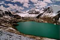
Lake Merzbacher
Lake Merzbacher is actually two separate lakes. While the blue waters of the upper Merzbacher lake are ice free, icebergs choke the lower lake. Once a year during August or sometimes the end of July, the lower lake swells and ruptures the glacial walls containing it, forcing water into the glacier’s chasms. The glacier spews icebergs torn from the foot of the glacier onto the silt bed below, raising the water in the Inylchek river. Besides Khan Tengri the Tengri-Too also contains Chapayeva, Gorkovo, and Petrovskovo.
Western Tian Shan
Free Korea Peak, Ala Archa
Western Tian Shan includes the Kyrgyz Alatau Mountains which extend 400 km east to west. The most popular spot for climbing is the Ala Archa National Park only 35km from the Kyrgyz capital of Bishkek. The valley is even served by local public transport from the capital. There is a small fee (around $1) to be paid at the park entrance and also for bringing vehicles. Beyond the gate the road continues 12km to a small collection of buildings including one newly renovated lodge. At the road, to the left lies Ak Sai Glacier, to the right is Agadinye valley where the climber's cemetery is located, and straight continues down the valley for 10km to an old - now abandoned - ski area. The park is open year round although the most popular season is later summer and early fall. Alamedin valley is also easily accessible from Bishkek.

Mountains above Almaty
All peaks are below 5000m, however, since the Tian Shan’s snowline decreases from the southeast to the northeast, snow and ice routes are still numerous with some excellent rock and mixed routes as well. The highest peaks, above the Ak Sai glacier, are Semionova-Tienshanskogo Peak (named after the famous explorer) (4875m), Mt. Korona (Crown, 4860m), the Allam-edinskyja Stena (4720m) and Svobodnaya Korea (Free Korea, 4740m). The most interesting and difficult routes lie on the northern face of Svobodnaya Korea and on the western slopes of the 1000m vertical Korona Towers. This area alone would justify a trip to the Tian Shan. It is also an excellent spot to acclimatise for higher peaks.
Besides climbing white water kayaking is popular on the Ala Archa river. The area is also popular with local skiers in winter.
More information on Ala Archa
From Mount Manas (4482m), the highest peak in the Talassky Alatau on its northern edge, the Western Tian Shan drops off west to disappear in the great sands of Asia. In between, it weeves in the Chatkal, Chandalashsky, Pskem, Maidantal, Ugam, Fergana, Kuraminsky, and Atoinoksky ranges. At higher altitudes much of the Western Tian Shan is high-altitude steppe. The mountains in the west are mild and hiker friendly but be prepared for bushwhacking in some valleys. High ridges usually losing all snow early in the hot, dry summers.
Parts of the Western Tian Shan can be accessed from Tashkent in a few hours but to reach the really wild and beautiful country it is best to venture farther east to Namangan or Andizhan and start there. Stock up in Tashkent, or en route in Chirchik.
The Western Tian Shan is best visited from May to October with a high risk of avalanches outside these months. Hikers may want to visit the area in spring when things are still green and blossoming. Fewer than half of these days are sunny during these months however the heat of summer is avoided. Summer temperatures: 20 degrees average (can get as hot as 30 or 40 degrees).
Northern Tian Shan
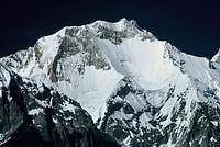
Tomur Feng (Pik Pobeda)
The Northern Tian Shan runs along the border between Kyrgyzstan and Kazakhstan and consists of the Kyrgyz Alatau in the west and the Zailiyskiy Alatau and Kiungey Alatau in the east, south of which is Lake Issyk Kul. The Kyrgyz Alatau straddles the Kyrgyz-Kazakh border west of Bishkek. The Zaaliyskiy Alatau can be easily accessed from the city of Almaty in Kazakhstan which lies only 40km to the north. Few cities in the world boast a backyard mountain range like the Zailiyskiy Alatau. Despite the close proximity the region is unspoilt. Only the Malo Almaatinskoe valley receives significant numbers visiters, the majority attracted by the valley's Chimbulak ski resort which is the best in Central Asia.
To the south the Kiungey Alatau is also easily accessible from the northern shores of the huge Lake Issyk Kul. There are a number of possible treks through the Northern Tian Shan that cross the border between Kyrgyzstan and Kazakhstan. In summer snowline is around 3800 to 4100m. Trails between Almaty and Issyk Kul are frequently used and easy to follow. The tallest peak in the region Talgar (4973 m).
The Northern Tian Shan is the traditional mountain homeland of the Kyrgyz and Kazakh people, although these tribes are not limited to the Northern Tian Shan. The Kazakh’s range extends through the Altai into present-day Mongolia and the Kyrgyz have relatives as far south as the southern Pamir in the Xinjiang Province. The Kyrgyz and Kazakh peoples were wanderers until last century, and cities are recent innovations in the Northern Tian Shan. Bishkek (formerly Frunze) was a minor settlement prior to the arrival of the Russians.
Chinese Tian Shan - general classification

The Chinese Tian Shan can be broken down in three main categories.
1. In the east you'll find the Bogda Shan, a mountain massif with all kinds of climbing. Difficult and hard ice routes as well as easy and beautiful trekking. The access is usually easy as there are many roads leading into the heart of the range.
2. Easy trekking peaks with easy access in the middle parts of the range. Most of the peaks can be reached in a few days from any of the roads leading through the area. No special permits needed.
3. The high Tian Shan in the west of the range. It's at present very hard to get permits for this area and access is many times hard, long and difficult. So are many of the peaks in the area and there are still some high unclimbed summits in this part of the range.
An e-book about the Chinese Tian Shan compiled by Tracksterman.
Chinese Tian Shan - The main range

Unnamed 5000m peak
It's in the western parts you'll find all the highest peaks. Highest of them all is Tomur Feng more well known as Pik Pobeda. It's a hard peak to climb and it's only successfully climbed once or twice from China. Second highest is Khan Tengri the other peak over 7000m. These two are the most northerly mountains of this elevation. There are many other high border peaks, which can be climbed from the Chinese side. It's a very uncommon option and be prepared for a pioneering feeling heading into this seldom visited range.
Bogda at sunset
The central part consist of two parallel ranges, with a lush green high plateau in between. All peaks here are below 6000m. There are very few roads crossing the plateau and off these, you have to go with 4x4 or on horseback. Despite this traveling is quite straight forward as most areas consist of huge plains of grass. When in the actual ranges, the topography is rugged and deep valleys and steep mountain sides effectively blocks the way for anyone but the most determined.
Camping
Camping anywhere near habitation will guarantee you an immediate audience.
Camping is officially illegal in China but in the reality no one cares if you camp or not as long as you don't pitch your tent in Urumqi City park.
There's no problem with camping wild in the Stan's in general. Camping areas on popular trekking routes. Uzbek police are known for their corruption so again camp where you won't draw to much attention.
In Kyrgyzstan if you don't want to stay in yur own yurt you can stay in family yurts across the country. Visit C'ommunity-based tourism' office and you'll be presented with often a long list of family yurts you can stay. They can also help you with reach the areas which are often very remote and unspoilt. The yurt-stays are very uncontrived and one of the best schemes for tourism that I've encountered anywhere. It's worth taking advantage of the scheme at some point if you're in Kyrgyzstan.
In Kyrgyzstan yurt camps are popular with climbing expeditions. These aren't traditional family yurts but yurts pitched in a compound (some of which are very nice). They are usually cheap with basic facilities. You can pitch your tent here for a small fee.
Climbing Conditions
The Central Tian Shan is a harsher environment than the Pamir, colder and more precipitous. Experienced mountaineers say the effects of altitude are felt more acutely because of the northern latitude and compare it to 8000m in the Himalaya. The Tian Shan are not the mountains for aspiring high-altitude climbers to cut their teeth on and experience is a must.
Maps
Check out the map shop called Geoid in Bishkek which has some excellent trekking and 1:200,000 maps although text will be in Cyrillic.
SP member Vladimir Kopylov has made a lot of good sketches of maps and routes.
Maps
The Northern Tian Shan
Ala Archa Region
Karakol-Djeti Oguz Region
Khan Tengri-Pobeda-Bayancol Region
Routes
First Tower of Mt. Korona - West Side
First Tower of Mt. Korona - North Face
Fifth & Sixth Towers of Korona - South Faces
Mt.Svobodnaya (Free) Korea - North Face
Mt. Djigit - North Face
Mt. Karacolskiy - North Face
Terskey Ala-Too range
Oguz Bashi - North Face
Khan Tengri - Routes from South
Khan Tengri - West Ridge
Khan Tengri - North Face
Pobeda - North Face
Bayancol Valley
Mountains of the Tian Shan on Summitpost

| [img:40265:alignleft:small:Bodga Uia V (5213m)] | [img:173487:alignleft:small:Pik Becherovka (4905m)] |
| [img:40279:alignleft:small:Nanfeng (4683)] | [img:40255:alignleft:small:Xifeng (4596m)] | [img:42214:alignleft:small:Xifeng South Peak (4275m)] |
External Links
Trim report and photos of ascent of Voennih Topografov (6873m) in the Chinese Tian Shan (2006)
An e-book about the Chinese Tian Shan compiled by Tracksterman.