The Hike...
I’ve visited Linville Gorge quite a few times but never managed to make it off the rim. I decided to combine one of the more popular trails in the gorge with one of the most difficult. I would park at the Sandy Flats Trailhead, walk a mile back up the road to the Babel Tower Trail and descend into the gorge that way. Then, I would follow the Linville Gorge Trail downstream to the previously mentioned Sandy Flats Trail and make the 1200’ climb out of the gorge.
The hike began well enough. I don’t particularly like road hiking but the mile to the Babel Tower Trail was over quick enough and I was soon heading
down into the gorge. The Babel Tower Trail is one of the more popular trails in the gorge and it showed. None of the trails in Linville Gorge are signed or blazed but that wasn’t a concern on this path. The trail was overgrown in places but never rugged or steep. Within about a half hour I had made my way the 1.2 miles down into the gorge. The Linville Gorge Trail crosses here but I headed straight ahead for
Babel Tower itself. The trail follows the north side of the tower. My guidebook told me how to get to the tower but precious few details about where the access to the top was. I followed the path around to where I found a place in the wall where I felt I could scramble up safely. It was a bit of a climb and I wasn’t sure how I was going to get down but I figured I’d worry about that later. At the top I was treated to some of the most beautiful views of the gorge I have ever seen. I found a nice spot for a snack and just took in the views.
I reluctantly decided it was time to move on and went about looking for a way down. Before too long I found a relatively easy way down off the northeast side of the tower. From the bottom I made the ¼ mile hike back up to the Linville Gorge Trail. I eventually want to travel all the trails in the gorge so I decided to head north on the Linville Gorge Trail about a mile to where the Cabin Trail meets it.
I was going along nicely when I came to a large fallen tree. Beyond the tree…nothing, no trail, just thick rhododendron hedges. I climbed up on the trunk and walked up and down the 50’ trunk at least a half dozen times trying to make out any form of trail to follow. I couldn’t see anything. I broke out the map and noticed the trail tended to head down hill so I set off in that direction after no more than 200’ I found the trail. I was relieved it was that easy. After making it the rest of the way to the Cabin Trail and then backtracking I found the point in the trail where I went wrong. The trail without warning drops about 15’ over a rock outcrop. With no markers of any kind I followed my instincts to no go over a cliff edge and had made a left. Oh well, this is why you need a map in the gorge!
I passed the
junction with the Babel Tower Trail and continued south on the Linville Gorge Trail. The ½ mile or so just south of Babel Tower is quite steep with numerous switchbacks. The
views along this section are hit-and-miss but
beautiful. Soon the trail drops to within about 100 vertical feet of the river and there are numerous side trails leading down.
I spent some time down by the river climbing boulders and taking photos. I then grunted my way back up the 100’ to the trail. The Linville Gorge trail continued to be typically rugged. About halfway between the Babel Tower and Sandy Flats trails it is literally cut into an exposed rock face. After about 2.5 miles you enter an open area with a number of
huge hemlocks. This was supposed to be where my exit route, the Sandy Flats Trail, headed up out of the gorge. At this point it had to have been above 80 degrees and I was starting to question my decision to make the hardest trail in the gorge my way out. I figured it would be best to take a good long lunch break before starting the climb. I scrambled down to the
river and found a nice big rock to stretch out on. I spent the better part of an hour relaxing, having lunch, and rock-hopping along the river. I had rested, but was still not looking forward to the climb.
Whoever named the Sandy Flats Trail had a sick sense of humor. There is no sand anywhere and nowhere is the trail “flat.” The trail makes climbs a vertical 1200’ in only a mile from the Linville Gorge Trail to the parking area on the Kistler Highway. A better name would have been the
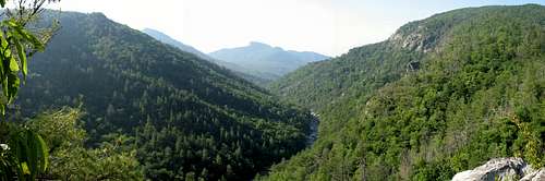
Rocky-Steep-as-Hell Trail. I got my self pumped up and headed back up to the trail junction. I then discovered I had a problem…to trail. I spent at least 20 minutes walking up and down the Linville Gorge Trail trying to find something that resembled a trail heading uphill. Just before I was about to give up and head back via the Babel Tower Trail (not cool) I noticed a piece of white tape hanging from a tree. THE TRAIL!! I started to climb, and climb, and climb. The freaking trail didn’t let up. No switchbacks or anything, just straight up the mountain. What was I thinking?! The trail would have been all but impossible to follow if not for the white pieces of tape someone had left hanging here and there. After countless rest stops I topped out on a rock face with a stunning view across the gorge of Hawksbill. It was great but I was almost too tired to enjoy it. From the cliff there was still about ¼ mile of steep trail to climb but I moved a bit faster knowing I was near the top. Before long I was back in the car enjoying some air conditioning.
![Sandy Flats Trail Pano]()
IMPORTANT NOTICE!!!
I have recently been informed that the Sandy Flats trail has been officially closed. In the couple of years its been since I did this hike I imagine all trace of the trail has been overgrown. Guess I can say I was one of the last few people to travel it...though I'm not sure if that is a boast or a complaint! RIP Sandy Flats Trail...


Comments
Post a Comment