
|
|
Area/Range |
|---|---|
|
|
35.92270°N / 81.90411°W |
|
|
Hiking, Trad Climbing, Sport Climbing, Toprope |
|
|
Spring, Summer, Fall, Winter |
|
|
4100 ft / 1250 m |
|
|
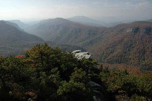
The Gorge Area - Overview
The Linville Gorge is a 12,000 acre component of the USFS Wilderness system. The Linville River drops almost 2000 feet as it cuts a gorge 13 miles long in dropping from the Appalachian mountains to the Piedmont region of North Carolina. The gorge bottom is traversed by the Linville Gorge trail (LGT), paralleling the river through the length of the wilderness. The river can be accessed by many trails descending from the rims to the river. Climbing areas include Hawksbill, Table Rock, the Chimneys, Shortoff, and Wisemans View. One can spend weeks climbing in the gorge and never repeat the same route.Linville Gorge is located on the southeastern slopes of the Appalachian Mountains, between Mount Mitchell (highest point in the entire Appalachians & east of the Mississippi) and Grandfather Mountain (highest point in the Blue Ridge Mountains).
The gorge is running in north-south direction and was formed by the Linville River flowing deep in the bottom of the canyon. The river descents from the Linville Falls at the north end about 2000 vertical feet, until it breaks into the open levels of the Catawba Valley and Lake James (reservoir). The Linville River has its source near Grandfather Mountain.
The west rim called Linville Mountain, a chain of wooded hills with steep rock outcroppings half way between crest and bottom of the canyon, and the east rim with several steep rocky peaks form the gorge. Elevation ranges from about 4000 feet average of the peaks and 1300 feet of the riverbed.
The entire area is heavily wooded with a hardwood and pine forest. The forest is often under grown by dense rhododendron bushes. Linville Gorge is part of Pisgah National Forest, and most of the gorge area is designated as Wilderness Area (12,002 Acres).
 southern part of the Gorge
 northen part of the Gorge
Getting There
East RimTake N.C. 181, coming from the north about 3 miles past the intersection with N.C. turn right into Ginger Cake Road. There is a big sign from the forest service and from here it’s about an other 2 miles to the gravel surface forest road.
From the south it is a little bit more difficult to find the southern end of the forest road, but there is a forest service sign as well indicating 13 miles to Table Rock pick nick ground.
West Rim
Turn on to N.C. 183 fro HWY 221 and after 1 mile turn into Kistler Memorial Highway. Kistler HWY is not a paved highway, it's a rugged gravel surface road and can get very rough sometimes.
Mountains In The Gorge Area
From a hiker or climber’s view the east rim offers the most interesting mountains and trails. Let’s start at the southern end of the gorge.THE JONAS RIDGE (east rim)
SHORT OFF MOUNTAIN seen from Lake James has an impressive rock face to it’s west side. Basically Short Off Mountain is forming the southern mouth of the gorge. A mellow back is running north toward Table Rock, the crest is wooded with some rock outcroppings.
TABLE ROCK is an impressive and dominant rock formation if you approach the gorge from the south. It is visible far from the foothills of the Catawba Valley. Table Rock is dropping steep to all of it’s sides. The southeast face is vertical rock an offers excellent climbing.
HAWKS BILL is a pyramid shaped mountain with a nicely tipped rock outcropping at it’s peak. Table Rock and Hawksbill are creating a very deep gap, which offers hiking access into the gorge; it’s called the Spence Ridge.
SITTING BEAR is the most northern peak in the Jonas Ridge. Has some rock outcroppings but mostly wooded.
 Table Rock - Amphitheater - Short off Mtn (east rim)
LINVILLE MOUNTAIN (west rim)
The west rim is more of a long stretched back with several humps as highpoints. It does not have a distinctive peak; the most northern hill is called the Linville Mountain. A forest service road (Kistler Mem Hwy!) follows the entire rim from north to south. About half way down or up the road a turn off to Wiseman’s View grants fantastic views to all the peaks of the entire east rim. A rockband at about mid elevation stretches all the way down on the entire length of the Gorge. The trails on this side of the canyon have to find a way though the vertical step, giving them a difficult touch.
 Linville Mountain (west rim)
The Wilderness Area - Red Tape
The Linville Gorge Area is protected by the 1964 Wilderness act.Wilderness Management
The Wilderness Act also spells out the Forest Service Role in managing the area. It says wilderness should be protected and managed to preserve its natural conditions and wilderness character. And it should be administered for the use and enjoyment of the American people in such a manner as will leave it unimpaired for future use.
What is allowed?
Hunting and fishing according to state game and fish regulations
Trail construction and maintenance
Primitive facilities if critical to the protection of the resources
Outfitter/Guide operations by permit
Use of motorized equipment in some emergencies
Prospecting but no mining
Collection of nuts, comes and berries for personal use
What is not allowed?
Roads
Timber harvesting
Structures
Mechanical transport (bicycles)
Motorized vehicles and equipment
Aircraft landings
Commercial enterprises
Removal of plants, stone, moss for personal or commercial use
Removal of historical or archeological artifacts
Climbing In The Gorge
Climbing areas are:Shortoff Mountain
Devil’s Cellar
Chimneys
North Carolina Wall
Amphitheater
Table Rock
Hawksbill
Sitting Bear
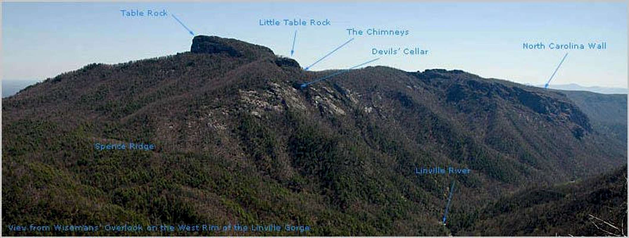
The most popular and easy to access areas are Table Rock, The Chimneys and the North Carolina Wall and to the north of TR are Little Table Rock and Devils’ Cellar. They all are reached via hiking trails from the Table Rock parking lot within relatively short hiking time. The North Carolina Wall is the farthest away.
Hiking In The Gorge
Hiking trails:East Rim Trails
Short off Mountain Tr.
Cambric Ridge Tr.
Table Rock Tr.
Spence Ridge Tr.
Jonas Ridge Tr.
Devil’s Hole Tr.
Brushy Ridge Tr.
Deep in the Gorge
The Linville Gorge Trail follows the Linville River in its entire length at the bottom of the canyon.
West Rim Trails
Pinch in Tr.
Rock Jock Tr.
Conley Cove Tr.
Sandy Flats
Babel Tower Tr.
Bynum Tr.
Cabin Tr.
Bynum Bluff Tr.
Pine Gap Tr.
The west side of the gorge is Linville Mountain, with the overlook of Wisemans view in the middle. Linville Mountain is traversed by the Kistler Memorial Highway (old NC 105). The trails dropping into the gorge from the west rim are (North to South) Pine Gap, Bynum Bluff, *Cabin, Babel Tower, *Sandy Flats, Conley Cove, and Pinch-In. (The Sandy Flats is no longer considered a trail by USFS)
The east side of the gorge is a series of separate peaks (N to S): Sitting Bear, Hawksbill, Table Rock, the Chimneys, and Shortoff. It is accessed by Table Rock Road and the Shortoff Mountain (now the Mountains to Sea) trail. The east side trails (N to S) are the *Brushy Ridge, *Devils Hole, Spence Ridge and *Cambric Branch. The Linville trail is 12+ miles and follows the river from the Pine Gap trail near Linville falls to private land at the southern end of the gorge by Shortoff Mountain.
The above trails are 0.8 to 1.5 miles in length, all the trails are steep and drop up to 1500 feet to the river. The trails noted by * are considered "primitive", though I wonder as to what this designation means. The toughest is the Sandy Flats trail. It is difficult to locate, poorly traveled, and drops 1200' in a mile. Other tough trails are Devils Hole and Cambric Branch. Both get scant use. The Cabin trail is steep but gets much more traffic. The Pinch-In is also quite steep with the greatest vertical drop but more traffic. The other trails get much more use, are easy to follow, and usually graded. Many day loops that can be walked if a strong hiker, by combining the trails and roads.
Bob Underwood maintains a great site (Linville Gorge) on Yahoo groups. He is most knowledgeable about all the trails. The gorge is full of unofficial trails
Because the area is a wilderness the trails are not blazed, though a few intersections are signed. It can sometimes be VERY difficult to locate the east side trails when hiking on the Linville Gorge trail (LGT), because the LGT stays on the western side of the river and only the Spence Ridge trail crossing obvious. A prohibited bridge was placed at this crossing in 2007 by the USFS. Further discussion on this topic can be found below. Just remember landmarks and consult the trail map often.
Camping In The Gorge
Camping permit required!Because this is a wilderness, groups are limited to 10 persons. Permits are required for camping on weekends and holidays in the wilderness from May 1 to Oct 31. These rules are routinely violated but you don't need to. (Violation is a federal crime and punishable by a $5000 fine and prison time. Rangers routinely monitor trails and hikers exiting them. Pleading ignorance will get you no mercy.) This area is being loved to death. For a permit. Contact:Grandfather Ranger District, Marion, NC 28752. Telephone: 828-652-2144 The camping areas on the LGT between Babel Tower trail and Conley Cove trail are heavily overused. Please tread lightly.
Excellent conditioning is required as well as water, compass, USFS Linville Gorge map or USGS 7.5' Linville Falls and Ashford, a good idea of direction, ability to read terrain and land forms, and common sense.
When To Climb And Hike - Climate
Linville Gorge is accessible all year. The spring and fall month are the best month due to relatively low humidity. Fall colors are spectacular and in spring time when the leaves are not peeking out yet, the views are fantastic through the bare trees.North Carolinas weather and climate is in general hot and humid during the summer month from June till the end of August. If you get out of the foothills and reach about 3500 feet in elevation the humidity drops down and the temperature as well for about 10 - 15 degree F. The peaks in the Gorge area are above that elevation and it makes up for a pleasant day when everybody else is sweating down in the valley.
Hiking in the bottom of the Gorge and on lower trails can be muggy and it cost's you a lot of sweat during the summer month. Bring plenty of drinking water!
Spring and fall are in general low in humidity and most pleasant for activities. The Linville Gorge has a very harsh winter climate with snow and ice. Not many visitors during that time are the trade off.
Other Attractions In The Gorge
The Linville Falls at the northern end. Beautiful cascading waterfalls with several hiking trails. (not located in wilderness area)Online Resources
Weather, Linville FallsUS Forest Service, Pisgah National Forest
Great climbing page from Wayne Busch
Books And Maps
Randy Johnson Hiking GuidesA great collection of guidebooks is found here
Other important/interesting information
Please be a good steward, don't break switchbacks, pack it in/pack it out (yours and someone elses garbage). Be smart; this is a very popular east coast climbing area so DON'T trundle rocks off the cliffs or drink to excess and do something foolish. Your silly action could get you or someone else killed. Summers can be very hot so look for rattlesnakes; winters are not too bad, though the access roads may be impassable due to ice or snow. When the mounains have snow, the lower gorge is usually snow free because of its elevation. Its all uphill when leaving to return to your car; so if you get off trail go up (BUT it can be unreal steep and you can be cliffed out or fall and get injured/impaled/incapacitated/killed.) Evacuation can be exceedingly difficult. (There are 1 to 2 rescues a year from the gorge, most are very long, time consuming, and difficult. Some require helicopter evacuation which greatly compounds the difficulty. There are no landing zones, patients must be short hauled.)The Linville River has been run by whitewater experts, having first been run in 1990? From American Whitewater on the Linville River: "The high gradient and complex geology of the gorge create intense and demanding rapids that are sustained for distances unparalleled in the eastern United States."
See Linville River
Manmade developement in a USFS Wilderness
As mentioned above, a footbridge was constructed over the Linville River, connecting the Linville Gorge and Spence Ridge trails in 2007. Many persons (including this author) were (and remain) opposed to the placement of this structure. What follows is a brief discussion of the legality of this action.In section 4c of the 1964 Wilderness Act (Prohibition of Certain Uses) it states, "....... no structure or installation within any such area". However, like most rules, there are exceptions. A structure is allowed as per Section 4d-4 (Special Provisions); "Within wilderness areas in the national forests designated by this chapter, (1) the President may, within a specific area and in accordance with such regulations as he may deem desirable, authorize........... other facilities needed in the public interest..........., upon his determination that such use or uses in the specific area will better serve the interests of the United States and the people thereof than will its denial."
The finished bridge was made as unobtrusive as possible. I do not advocate property destruction but if the bridge fell in the water, well........
History
Named for William Linville. He and his son John were killed and scalped by the Cherokee in the gorge in 1766.Linville Gorge was first designated a wild area in 1951 by the Chief of the Forest Service. With the signing of the Wilderness Act of 1964, the area became one of the original components of the National Wilderness System. The original 7,575 acres was increased to the present 12,002 acres by the 1984 North Carolina Wilderness Act.
ZachStone - Jul 7, 2009 3:43 pm - Voted 9/10
Gate ClosureDon't know if this is covered, but from Jan-April the gate for the road leading to Table Rock is locked where the pavement starts (last 8 switchbacks I think). You can still get up there, but it is a gross pavement slog up. But no crowds so there is a trade off
Stu Brandel - May 17, 2015 8:07 pm - Voted 10/10
Bridge OutThe controversial bridge over the Linville was out when I was in the gorge May 14, 2015.