
|
|
Route |
|---|---|
|
|
42.30000°N / 19.60000°E |
|
|
hike, the summit crest requires some scrambling |
|
|
Half a day |
|
|
walk-up |
|
|
Approach
This is the route from Montenegro. Drive or bus to Plav (the road from Podgorica goes via Mojkovac, Berane and Andrijevica, the main approach from Serbia leads via Novi Pazar and Rožaje, the road from Pec in Kosovo via Čakor is closed at the moment ). Here ask about the road to Babino polje, where there is the last Montenegrin settlement before the Montenegrin-Kosovar-Albanian border. It takes 10-15 km from Plav to Babino polje along a tarred road in a fair condition (occasional potholes). Those coming by bus will have to go on foot or wait for a lift. Traffic is rare but locals are sure to pick you up if they have a place in the car. The lift is always better, as the direction to Babino polje is not completely obvious. When coming by car and not knowing the way, keep in mind that you'll cross the river once and when you come close to it again, there will be a fork. You'll take the right road across the bridge. Then, you'll keep following the main road, passing by a few larger settlements (one is called Jara) until you reach the long and deep valley of Babino polje with shepherds' huts and cottages. You can park your car next to the road, it should be safe.
 |
Route Description
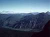
The Babino polje valley is surrounded to the left by an immense grassy ridge which forms the Montenegrin-Kosovar border. No soldiers or policemen protect this border on any of the sides, shepherds cross it every day with their flocks of sheep, so do not worry about authorities - the border stands open for hikers.
The ascent of Bogdash can last 4-6 hours (including the way back), depending on your pace (4 hours is a rush). I would divide it in three parts: attaining the border ridge, walking on the connecting ridge between Pasji vrh and Bogdash and scrambling for the summit.
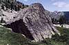
There are numerous paths from the bottom of the valley up onto the border ridge. You will probably not know which one to take, but this does not matter so much, as the terrain offers many variants. Just look out for rocky sections, which are rather rare on this hillside, but I strongly recommend to avoid them even if the path leads you there. Just walk back and take another turning if you come into rocks. The ascent is steep and long (700 m of elevation difference: the valley lies at 1500m and the border ridge at 2200m). The best way is to gain the cols alongside Mt Pasji vrh (2406m; either the northern or the southern col). Being there, you'll have the first opportunity to admire the beauty of Bogdash (2530m), which looms at the end of a smaller crest that runs from Pasji vrh. Unlike other eastern Prokletije peaks, Bogdash (and the massif of Koprivnik) is made up of limestone. Its white northern slopes shine brightly over the deep valley of Raski do, but also the southern flanks brood majestically above the Bjeshka Belegit high pastures.
Walk on from the col under Pasji vrh to the connecting ridge and pass it (an easy and relaxing walk at the same height after the initial demanding walk-up from Babino polje) until you come under the summit pyramide of Bogdash.
Now the scrambling begins. It is recommended to take the slightly visible trail across the first scree and then climb up along the sharp hillside directly to the first summit, decorated by the flag of Kosovo. From here, follow the crest and get the main summit after some 15-25 minutes of scrambling above gorges. This part is technical and very rewarding. From the top, you can see all other Kosovar Prokletije peaks (Žuti kamen, Nedžinat, Hajla, Krš Čevrlje, Veternik, Rops, Kurvala, Djeravica) and some other Prokletije summits outside Kosovo. Hike back on the same way.
Bogdash with its 2530 m ranks second or third after Djeravica (and maybe Maja Gusanit - this is disputable) in the Kosovar Prokletije mountains.
The Albanian settlements in the vicinity seem almost forsaken. Only few people stayed after the 1999 war. No incidents have been reported from this area for a long time, so I tend to think security is good here. The Montenegrin Muslims living in Babino polje abound with hospitality. Do not forget to have a glass of rakija with them.
You can climb Bogdash from Dečani or Peć, too, but I do not know these routes.
 |
Essential Gear
In summer, no special gear is necessary, even though the final scramble from the flag summit to the main summit is very exposed. After rains, rocks may become slippery and so dangerous. In winter, Bogdash can pose a serious challenge to even experienced climbers as far as I may judge (crampons, ice-axe, rope, ice-screws are a must then).
Trekking in the Kosovar Prokletije
I am thinking of doing 4-5 days' backpack trekking in the Kosovar Prokletije, roughly between July 24th and August 5th this year. We are three guys from the Czech Republic. The route would likely be Plav-Ridsko jezero-Bogičevica-Bogčes pass-Djeravica-Pločica-Kurvala-Maja Rops-Pasji vrh-Bogdaš-Pasji vrh-Starac-Djevojački krš-Čakor pass-Bjeluha village- Nedžinatska jezera-Nedžinat-Žuti kamen-Slane poljane-Veternik-Krš Čevrlje-Maja Streoc-Visoki Dečani monastery. If you are interested in this trip, you may contact us via email mulleri@aix.upol.cz.