
-
 14951 Hits
-
 79.78% Score
-
 11 Votes
|
|
Canyon |
|---|---|
|
|
Canyoneering |
|
|
Spring, Summer, Fall, Winter |
|
|
Overview: Hiking and Canyoneering
Bailey Canyon cuts a rugged swathe about a mile into the San Gabriel foothills above Sierra Madre, California. In the 1880’s, the canyon was exploited commercially by the trapping of foxes and coyotes for their furs. Today, the canyon’s uses are strictly recreational. The east slope of the canyon is graced by a hiking trail that affords access to the 3,375 foot Jones Peak, 5,715 foot Mt. Wilson, and to adjoining canyons like Little Santa Anita Canyon and Eaton Canyon.This canyon is also spotted with a number of falls down its length providing canyoneers with a route of about 12 rappels varying in height from 25 to 90 feet.
Although relatively short, this canyon is a deep one and should be avoided during or shortly after a rain. In 1994, a father and son hiking the canyon were swept to their deaths by a sudden debris flow. There are a number of signs at the mouth of the canyon warning hikers about mudflow and flooding.
There is one trail out of the Bailey Canyon Park trailhead and its path begins at the west end of the trailhead parking area. From the parking area, walk west and northwest through some trees and through a turnstile (yes, a turnstile). Proceed north on the closed asphalt road that skirts the west side of the Bailey Canyon debris dam. The asphalt turns into a dirt trail as you enter the canyon.
In 0.3 miles, there is a short, looped nature trail (the Live Oak Nature Trail) that splits right off of the main trail over a footbridge. At 0.4 miles, the trail hits a streambed and the Canyon View Nature Trail splits off to the left and follows the streambed for 0.2 miles to the Falls.
 Sign at Junction on Bailey Canyon Trail
If you are canyoneering, you will be coming back this way after your last rappel.
The (main) Bailey Canyon Trail continues up the east slope of the canyon coming to MacCloud Saddle in 1 mile. As you go up the trail, look back down to the mouth of the canyon; the long white structure you see is the monastery of the Mount Oliva Passionist Fathers.
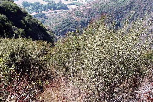 Looking down toward mouth of Bailey Canyon from Bailey Canyon Trail. The building at top left-center in front of the cluster of trees is the monastery of the Mt. Oliva Passionist Fathers.
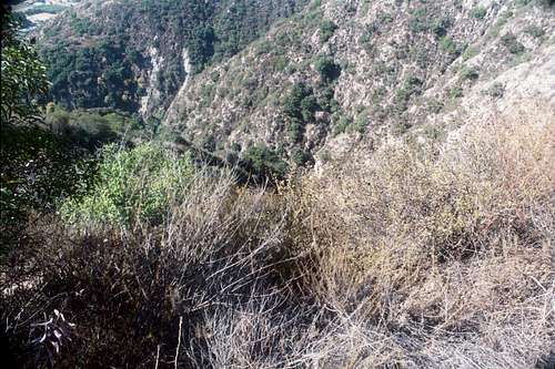 Another view down-canyon from the Bailey Canyon Trail
Look up-canyon, and you will see how steep Bailey Canyon is.
 Looking up-canyon from the Bailey Canyon Trail
If you are going canyoneering, your descent route begins behind some stone cabin ruins just off the main trail 2.2 miles from the trailhead. See"Adventure Hikes and Canyoneering in the San Gabriels" by C.E. Brennen
At 3.1 miles you will be at the upper end of Bailey Canyon at the saddle north of Jones Peak. Jones Peak is just 0.1 miles from the saddle up a use trail. From the saddle, a firebreak along a ridge going northwest connects to the Mt. Wilson Toll Road 5 miles from the trailhead, and one can continue up to Mt. Wilson along the toll road. Alternatively, a "connector" trail starting 0.2 miles north of the saddle drops 700 feet into Little Santa Anita Canyon and connects with the Mt. Wilson Trail. The Mt. Wilson Trail of course also goes to Mt. Wilson.
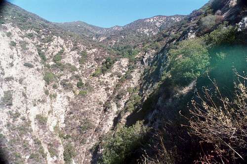
 Looking down into Little Santa Anita Canyon and the Mt. Wilson Trail (left center) from the upper end of Bailey Canyon near Jones Saddle
Getting There
The Bailey Canyon Park Trailhead is also known as Grove Park. It is situated within the city limits of Sierra Madre. From the 210 Freeway, exit at Santa Anita Ave. and go north. Turn left (west) on Grand View. Continue several blocks to Grove. Turn right (north) onto Grove and drive directly into the Bailey Canyon Park/Grove Park parking lot. There is a gate at the entrance to the park open “from dawn to dusk.” If you get there before the gate is open, there is parking along adjacent residential streets.Red Tape
No permits are needed for entry into this canyon nor for hiking on any trails it provides direct access to. Neither is an Adventure Pass required to park at the trailhead because it is not located within the Angeles National Forest.Camping
There are no camping sites in the immediate vicinity of this canyon.Other Information
USGS 7.5 Topo: Mt. Wilson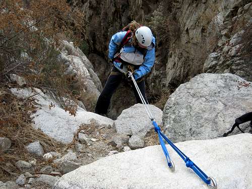 Canyoneering in Bailey Canyon Oct. 2006