
|
|
Canyon |
|---|---|
|
|
34.31601°N / 117.44565°W |
|
|
Hiking |
|
|
Spring, Summer, Fall, Winter |
|
|
Overview
Cajon Pass is a major canyon that separates the San Gabriel Mountains from the San Bernardino Mountains in Southern California. Owing its existence mainly due to the San Andreas Fault which slices up through this region, Cajon Pass is a natural thoroughfare that has been used for tens of thousands of years. For those interested in history, there is no shortage of it here!The Cahuilla and Serrano Native Americans called this region home for a long time. They had a huge camp called Muscupiabe where the modern day Hwy 138 and I-15 meet. Then the explorers came through - the Mojave, Santa Fe, Spanish, and Mormon Trails all converge here. In 1885 the Santa Fe Railroad was completed through the pass. Then came automobiles. The first paved road that came through in 1916. Soon after the Old Trails Highway came through, later relocated and widened and renamed Route 66. Route 66 opened up Southern California to the rest of the US. It was later renamed to State Hwy 91 and then eventually Interstate 15. Many traces of the old roads and railroad beds and stations still exist.
Today about a million cars travel through the pass on I-15 every week, beating out I-5 with record numbers of vehicles per day moving north and south through California. And the now three railroad lines comprise what may be the busiest railroad freight corridor in the world.
In addition to the fault, Cajon Creek, old trails, old roads, the extremely busy modern highway, and the railroad, there are three sets of high voltage power lines that are aligned through the pass, high pressure gas lines, and jet fuel lines that go through the pass. And, oh yeah, the Pacific Crest Trail crosses the canyon and goes underneath the freeway near the truck weighing station.
Whew, yeah, this is a busy place! The convergence of all these things, plus interesting weather and the chaparral hillsides being prone to wildfires, make this place insanely busy. But, the good news is the business is concentrated along the freeway and railroad corridor in the main canyon. If you explore its side canyons and bordering high peaks you'll probably have them to yourself. There are a lot of interesting things to discover in this important part of Southern California.
My favorite time in the pass is spring - March through May - when the wildflowers bloom. This year (2010) it's been a particularly nice year for the lupine and bush poppies.
Locals know the entire canyon from Devore up to Oak Hills as "Cajon Pass" even though geographically it's probably best described as a canyon. "Cajon Summit" is the high point of the pass at 4,190', or where the northbound lanes of I-15 crest the edge of Baldy Mesa and enter the High Desert. (It's slightly higher for the southbound lanes)
Getting There
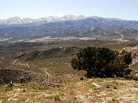
Take I-15 north of Fontana or south of Hesperia. If you exit on Kenwood in the south or Cleghorn in the north you can follow a portion of Old Route 66 that's still intact. If you exit on Hwy 138 you can see the famous Mormon Rocks or access the PCT. If you want a fantastic viewpoint from which to view the whole area, I highly recommend the hike up to Cajon Mountain. Other nearby peaks include Ralston, Gobbler's Knob, and Circle Mountain.Most of the land in this area is part of the San Bernardino National Forest. Click here to buy a forest map.
View Larger Map
Here are two spots where you can see some historical trails and roads in Cajon Pass:
Crowder Canyon - PCT
Exit northbound Interstate 15 at Highway 138. Turn right and immediately turn right again onto Wagon Train Road, which is old Route 66. Pass the McDonald's and drive to the end of the road. You will find a historical marker erected in 1917 and dedicated to the pioneers of the Santa Fe and Salt Lake Trail.
Across the road, notice the wooden sign identifying the Pacific Crest Trail, which is cut into the north side of the narrow canyon. The original Indian footpath from the desert to the Cajon Pass was in or near the creekbed below and it is along this creekbed that Jefferson Hunt entered the region on two separate expeditions.
About 50 yards up the Pacific Crest Trail are the remains of the concrete support for a bridge built in 1914. You'll also notice two types of asphalt on the trail. The darker underlying layer was put down in 1909 as a 9-foot-wide wagon road. The road was widened in 1914 to 16 feet and the lighter colored asphalt is the remainder of that road. Both overlaid the original dirt toll road built by John Brown in 1861.
Brown's first tollhouse sat about halfway up the canyon.
Blue Cut - Old Route 66
Exit southbound Interstate 15 at Cleghorn Road and turn right onto Cajon Road, again old Route 66, and head south. After about a mile, the road diverges from the interstate, heading west toward a large bend known as Blue Cut. Drive past the picnic area, and look for a safety wall constructed of rock.
This wall was built in 1931 as part of a two-lane widening project for Route 66. At the southern end of the rock wall, erosion has revealed areas where two layers of blacktop can be seen. The top is from the 1931 road, the lower layer is from a section of road built in 1916. Look across the creek and you will see an arched railroad underpass with the numbers 654 over it.
John Brown's second tollhouse sat just south of this underpass, on the far side of the creek. A sloping line rising along the hill to the north is the original wagon road. Looking across Route 66 and to the south, you can see a line of trees.
These mark the course of Cajon Creek before it was rerouted for the 1931 road project.
Red Tape
For hikers there isn't much in the way of red tape. You won't need an Adventure Pass to park, unless you park at the Trestles OHV staging area or Lost Lake. No permits are needed to hike.
One thing to note is that campfires are not allowed except in Yellow-post campsites and developed campgrounds, of which there aren't any in the pass itself. But there are some nearby in Lytle Creek.
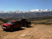
For OHV enthusiasts - The Baldy Mesa and Cleghorn Trails offer wonderful views of the pass and the north side of Mt. Baldy and I highly recommend them. They're suitable for ATV's, dirt bikes, and Jeep Wranglers or other similar high-clearance 4wd vehicle. Click here for the OHV map. If you don't have a license plate then you'll need a green or red sticker.
Camping
Closest campgrounds would be at Lytle Creek (either Applewhite Campground or the nearby yellow-post sites) or Silverwood Lake State Park.Suggested Reads
Trails and Tales of Cajon Pass by John and Sandy Hockaday - if you live in the area and ever have a chance to hear John talk, go! He's a wonderful story teller and an expert on the history and landscape of Cajon Pass. He ocasionally does presentations for local historical societies and San Bernardino State University.The Cajon Pass by Alice Eby Hall