
|
|
Area/Range |
|---|---|
|
|
44.23142°N / 71.07468°W |
|
|
Hiking, Trad Climbing, Ice Climbing |
|
|
Spring, Summer, Fall, Winter |
|
|
3566 ft / 1087 m |
|
|
Overview
Appalachian Mountains > White Mountains > Baldface-Royce RangeThe Baldface-Royce range consists of a string of peaks, all well under 4000 feet tall, lying on the border between Maine and New Hampshire (mostly on the New Hampshire side). Despite their modest height, they rise up 3000 feet higher than the Cold River to their east, overlooking relatively flat coastal plain extending southeast to the horizon. To the west, the terrain is spectacular in the opposite way, with views over the Carter Range to Mount Washington.

Eastman
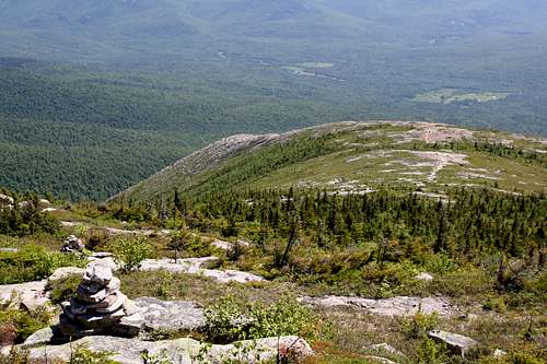
The crown jewels of the Baldface-Royce Range are North Baldface and South Baldface, the tallest in the range, the most ideally situated for views, and blessed with extensive alpine zones thanks to a fire in 1903. They are of course locally known and rather popular with hikers. In contrast, solitude is practically guaranteed on most of the other peaks in this range.
Not all the other peaks offer views from their summits, but you'll get views along most trails from atop precipitous east-facing ledges. At Evans Notch these become impressive cliffs nearly a thousand feet tall. (Several people informed me that scaling the cliffs is forbidden during peregrine falcon nesting season, but I know nothing about the rock climbing routes that presumably exist.) The east faces of this range are also home to several known vertical ice routes.
The range is located entirely within the White Mountain National Forest, but the most popular trailhead is on private land outside the WMNF boundary. (There is a parking fee collection station there nonetheless.)
The range is bounded on the east by state route 113 (Evans Brook, Evans Notch, and the Cold River). On the north and west it is bounded by Wild River Rd and the Wild River to Perkins Notch. On the Southwest I draw the line along the East Branch Trail (East Branch Saco River), and I take Mountain Pond (and the drainage just east of it: McDonough Brook) as a southern boundary. One could argue that the range extends further south to the hills that culminate at Kearsarge North, but at 1500 feet Mountain Pond is already much lower than Perkins Notch (~2500') which separates the Baldfaces from the Carters.
Neighboring ranges are: the Carter Range to the west (across the broad Wild River valley), the Mahoosuc Range well off to the north (on the other side of the Androscoggin River), the Caribou-Speckled Mountain group to the east-northeast over the narrow Evans Notch, the rather negligible Deer Hills to the southeast, and the aforementioned Kearsarge grouping to the south.
Mountains in the Range
South Baldface view
| Mt Hastings | 2167' | no trails |
| East Royce Mtn | 3114' | mostly-open summit |
| West Royce Mtn | 3210' | view east from ledge beside summit |
| Ragged Jacket | 2462' | not sure why this deserves a name |
| Mt Meader | 2782' | views from ledges |
| Eagle Crag | 3030' | north end of the alpine zone |
| North Baldface | 3610' | spectacular |
| South Baldface | 3570' | even more spectacular |
| Baldface Knob | ~3000' | south end of the alpine zone |
| Eastman Mtn | 2939' | good views - less wooded than it seems |
| Sable Mtn | 3519' | no trails |
| Chandler Mtn | 3335' | no trails |
| Round Mtn | 2181' | no trails |
| Slope Mtn | 2005' | no trails |
Getting There
IMPORTANT: the section of rte 113 through Evans Notch is closed and gated in winter (end November to mid May), usually from Cold River Campground north to route 2 (there are multiple gates). current statusThe more popular trailheads are on the eastern side of the range.
From Conway NH, head east on 302/113 to Fryeburg ME, where 113 North takes a sharp left (not well-marked, but if you see the sign for 5/113 South pointing right, backtrack a couple of blocks). Take route 113 (paved but bumpy) north about twenty miles for the Baldface Circle trailhead; farther for the other trails.
For the western trailheads, you need to access Wild River Rd, which departs rte 113 near its northern end (north of Evans Notch, not far from rte 2; specifically, just north of Hastings Campground).
If you are looking for the southern end of the Slippery Brook Trail, take rte 16 north through Conway and North Conway, and look for Town Hall Rd on your right in the village of Lower Bartlett. (If you reach Glen, where rtes 16 and 302 diverge, you've missed it.) Follow Town Hall Rd, which soon changes its name to Slippery Brook Rd (a.k.a. Forest Rd 17), about seven miles to the trailhead.
Getting to Conway from points south: If traffic is light, you can take rte 16 some 75 miles all the way from Portsmouth NH, which is on Interstate 95. (Part of this distance is the Spaulding Turnpike, a toll road.) If you prefer to maximize your highway miles, you could take Interstate 93 north (also a toll road), and turn east on your choice of rte 25, 112, 302, or 2.
Red Tape
Parking $3/day at most trailheads.The lower sections of the Baldface Circle and Meader trails are on private land, so please stay on trail.
Within the WMNF, reasonable rules apply re: fires, litter, hunting, etc. See backcountry rules under camping; see also the White Mountains page on Summitpost.
Trails & Trailheads
ridge trails
Starting from the summit of Eastman Mountain at the southern end of the range:

East Royce summmit
Eastman Mountain Trail is a short spur connecting the summit to the Slippery Brook and Baldface Knob trails.
Baldface Knob Trail covers the short distance along the ridge (and over Baldface Knob) between the Eastman Mtn Trail and the southern leg of the Baldface Circle Trail.
The Baldface Circle Trail is a loop whose western half runs from the Baldface Knob trail, over both Baldfaces, to Eagle Crag.
The Meader Ridge Trail runs from Eagle Crag to Mt Meader.
The Basin Rim Trailcovers the ridgeline from Mt Meader to West Royce.
A small section of the Royce Trail crosses the col toward East Royce. The Royce Trail then turns south, but not before meeting:
The Royce Connector Trail covers the tiny distance between the Royce Trail and the East Royce Trail.
Finally, the top 0.2 miles of the East Royce Trail get you to the summit of East Royce.
Access from the East
The Baldface Circle Trailhead offers parking and a choice of loops over the Baldfaces:

Evans Notch cliffs
Slippery Brook trail, gentle southern detour around the South Baldface ledges, or direct line to the Eastman Mountain spur.
Baldface Circle Trail (south half), a shelter along the way below some fun ledges.
Bicknell Ridge Trail An alternative to the north half of Baldface Circle.
Baldface Circle Trail (north half).
All of these converge near Emerald Pool, less than a mile from the trailhead.
Two trails reach more northerly points from the east, and may be suitable for a larger loop (with some road walking):
Less than a mile north of the Baldface Circle Trailhead, the Mt Meader Trail climbs to its eponymous peak. Parking is limited and not obvious.
The Basin Trail climbs from Basin Pond to Rim Junction north of Ragged Jacket. Park at the Basin Campground.
Three trails converge near East Royce:
The Royce Trail heads mostly north from Brickett Place just northbound (actually mostly east) of the Basin Campground entrance. Not sure about parking.
The Laughing Lion Trail is a rather direct upward hike near the southern end of the cliffs of Evans Notch. Park in the picnic area.
The East Royce Trail is even steeper and goes around the cliffs on the north side (starting very near the height-of-land in Evans Notch). There is parking at the trailhead.
Access from the West
To reach these trails requires, at the least, a drive down Wild River Road; the more southerly trails require a long hike on the Wild River Trail (or a long descent from the Carter Range to the west). From south to north, they are:
Eagle Link arrives at Eagle Crag.
Black Angel Trail arrives at Rim Junction. {This trail actually starts on Carter Dome but crosses the Wild River trail at the south terminus of the Highwater Trail}
Basin Trail also reaches Rim Junction (starting near Wild River Campground)
Burnt Mill Brook Trail reaches the col between the Royces.
Access from the South
Slippery Brook Trail climbs gently for four miles from its namesake road (near Mountain Pond) to the Baldface Knob and Eastman Mtn trails. (Slippery Brook Trail then turns east and descends to Emerald Pool, as noted above.)
Camping, Huts, etc
trailside campsites & shelters
South Baldface shelter
With one exception, these shelters, campgrounds, and cabins are managed by the White Mountain National Forest (USFS). For more info try calling the Saco Ranger District at 603-447-5448 or the Androscoggin Ranger District at 603-466-2713. Info on these remote spots is hard to find online, if you learn anything useful please share it in comments to this page.
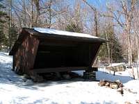
South Baldface Shelter - just below the steep section of South Baldface's eastern spur.
Blue Brook Shelter - On the Black Angel Trail, high on the northwest side of Ragged Jacket.
Spruce Brook Campsite - in the middle of the Wild River valley, about halfway between Perkins Notch Shelter and Wild River Campground. Tent sites only; former Shelter dismantled around 2010
Perkins Notch - at the head of the Wild River, about halfway between Carter Notch and Eagle Crag. An option for a western approach. Shelter being demolished during August 2011; three tent sites will be created
Mountain Pond Shelter - on the Mountain Pond Loop trail off Slippery Brook Rd, an option for the long approach via Slippery Brook Trail's southern end.
backcountry camping
Within the WMNF, allowed below treeline and 1/4 mile from roads, shelters, or other structures. Also, you must be 200 feet from the Wild River Trail.
full rules (PDF format)
Remember that the lower parts of Baldface Circle and Mount Meader trails are on private land, not WMNF land.
Also, review the full rules for slightly stricter provisions within the Caribou-Speckled Mountain Wilderness which occupies most of the area east of Evans Notch.
rem caribou-speckled mtn Wldrnss
huts
There are no huts within the boundaries of the range as defined above, but three huts on its fringes might be of some interest during an extended stay:
Carter Notch Part of the AMC system of High Mountain Huts, this one is located on the crest of the Carter-Moriah Range. From here to Eagle Crag or Rim Junction is six or eight miles as the crow flies, somewhat longer via seldom-used trails. details, reservations, etc
Doublehead Cabin Located atop a 3000-footer to the east of Jackson, NH and west of Mountain Pond, this cabin is geographically just outside the Baldfaces but does not lend itself to reaching them by trail or by road. reservations (be sure to read the details eg "bring your own drinking water")
Black Mountain Cabin Located about three miles northwest of Doublehead cabin and similarly inconvenient for access to the Baldface Range. reservations
roadside campgrounds

Mt Meader from the Basin
For details and reservations at the campgrounds listed below, click the appropriate link in this table or the right spot on this map.
Basin Campground - at The Basin east of Mt Meader, on rte 113.
Cold River Campground - Near the Basin Campground but closer to the highway.
Wild River Campground - deep in the Wild River basin on Wild River Rd.
Hastings Campsite - on Rte 113 near the junction with Wild River Rd (not far from Route 2).
Conditions & When to Climb

The peaks of this range are not very tall, so temperatures won't be much different from the readings above. However, be prepared for high winds on the Baldfaces as you will be above treeline for a while.
Several trails are somewhat steep but the only one I know deserves a special bad-weather caution is the southern leg of the Baldface Circle Trail: the above-treeline ledges on the eastern spur of South Baldface are quite interesting when icy.
The peaks in this range can be hiked year-round. Normally no special equipment is needed. Summers tend to be hot and humid with a good chance of biting insects; late spring and early fall are ideal for relaxed hiking; winter poses obvious challenges plus closed roads.
In winter and early spring:
- some navigational and route-finding skills may be needed on the Baldfaces above treeline.
- bring snowshoes as the ridge trails will only rarely be broken out. It's a good idea to bring crampons too, especially for the southern half of Baldface Circle.
Note that the northernmost section of route 113 (ie, north of Evans Notch [by East Royce]) is not plowed in winter.
Resources
Books & Maps
Rhodora
AMC White Mountain Guide, $22.00. Includes trail descriptions and topographic maps (on paper).
You can also order tyvek versions of the maps separately for $24.00 Buy direct from the AMC
Forest Rangers
I believe the Baldface-Royce range falls within the Androscoggin Ranger District.
300 Glen Rd
Gorham, NH 03581-1399
(603) 466-2713 x 0
(603) 466-2856 TTY
Office Hours: Monday - Friday 8:00 AM - 4:30 PM
Also of use: Evans Notch Information Center
(207) 824-2134 TTY (207) 824-3312
18 Mayville Road Bethel, ME 04217 Monday - Friday 8:00 AM - 4:30 PM
External Links
Additional photos from my hikes to this range:Baldface Range traverse (summer)
Baldface Circle loop (spring)