
|
|
Area/Range |
|---|---|
|
|
44.27000°N / 71.3°W |
|
|
6289 ft / 1917 m |
|
|
About this page
This page provides an overview of the Presidential Range, and links to the individual mountains in the Range.
The page also has an attached climber's log where you can record your Presi Traverse attempts.
When posting to this page, please submit only photos or routes that include several mountains in the range. Try not to duplicate material that is already available in the individual mountain pages.
A propos de cette page
Cette page présente un aperçu de la Chaîne Présidentielle, et offre des liens qui mènent individuellement aux montagnes de cette chaîne.
Si vous ajoutez des suppléments à cette page, veuillez vous limiter à des photos ou des voies qui concernent plusieurs montagnes de la chaîne.
La page possede aussi un carnet qui servira à afficher vos Traversées Présidentielles.
Essayez de ne pas dédoubler les informations déjà disponibles sur les pages propres de ces montagnes. (A noter aussi: les commentaires photos entièrement en français sont tolérés, mais les voies et les autres types d'objet doivent fournir des informations en anglais.)
Un grand merci à Ario pour avoir corrigé les sections francaises de cette page.
 |
News and Events
(last updated: August 2011)
Adams 4 renamed: Mt Abigail Adams
Official entry - note "Decision 2010".
Additional Info
New avalanche website
Moved from Tuckerman.org:
mountwashingtonavalanchecenter.org
Madison hut renovations
Work is complete and the hut is open.
a tiny bit more detail
Overview
Appalachian Mountains > White Mountains > Presidential Range
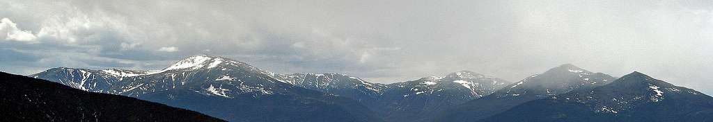
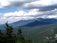
from the southwest
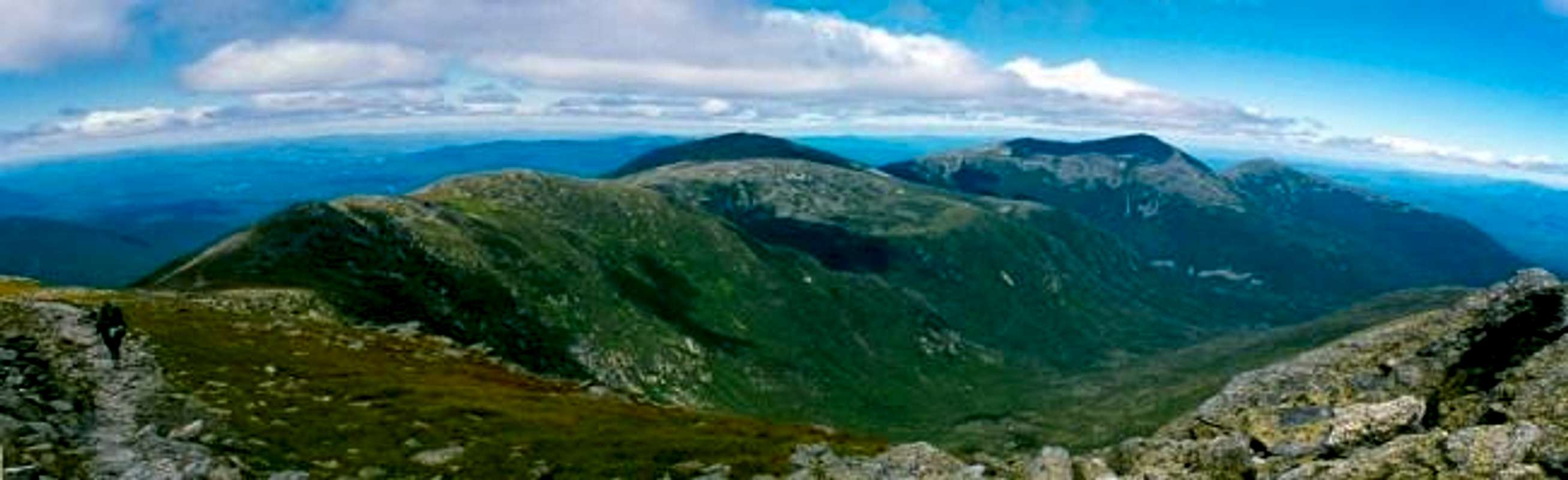
The Presidential Range is a distinct, contiguous chain, about twenty-five miles long (not counting the Southern Ridges or the Dartmouth-Cherry Range), containing the highest peaks in New England. The Range is located within the White Mountain National Forest, which itself contains most of the White Mountains. New Englanders earn bragging rights by performing a one-day presi traverse.
The heart of the Presidential Range, its main ridge, runs roughly southwest to northeast, from Webster Cliff in Crawford Notch, about twenty-five miles to Mt Madison. Near the center of this ridge is Mt Washington, the highest point of the range. It is sometimes convenient to distinguish between the main-ridge peaks north of Mt Washington (the "northern Presidentials"), which are all high and rocky, and the main-ridge peaks south of Mt Washington (the "southern Presidentials", not to be confused with the "Southern Ridges") which generally don't have quite the same height or aspect.
In addition, some less-famous ridges should be included in the range: the Southern Ridges which, of course, extend south from near Mt Washington, and the Dartmouth Range which lies to the west of the main ridge.
Aperçu
Les Appalaches > Montagnes Blanches > Chaîne Présidentielle

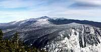
from west
La Chaîne Présidentielle est une chaîne continue d'environ quarante kilomètres de long (sans compter les Crêtes du Sud ni la Chaîne Dartmouth-Cherry), qui contient les plus hauts sommets de la Nouvelle-Angleterre. La chaine se trouve dans la Forêt Nationale des Montagnes Blanches [White Mountain National Forest], qui elle-même inclut la plupart des Montagnes Blanches. Les Néo-anglais trouvent de quoi se vanter s'ils réussissent la traversée des "Presis" en une seule journée.
Le coeur de la chaîne Présidentielle, sa crête primaire, s'étire plus ou moins dans une direction sud-ouest / nord-est sur environ quarante kilomètres, depuis la falaise Webster située à Crawford Notch, jusqu’au Mont Madison. Pres du centre, on trouve le Mont Washington, le point culminant de la chaîne. Il est parfois utile de distinguer, d'une part les sommets de la crête primaire situés au nord du Mont Washington (les Présidentielles du Nord) qui sont tous assez hauts et rocheux, et d’autre part, les sommets situés au sud du Mont Washington (les Présidentielles du Sud, à ne pas confondre avec les Crêtes du Sud), dont la plupart ne représentent ni les mêmes altitudes, ni le même aspect alpin.
La chaine Présidentielle contient d'autre part les Crêtes du Sud, situées bien sur au sud du Mont Washington, et la Chaîne Dartmouth-Cherry, située a l'ouest.
|
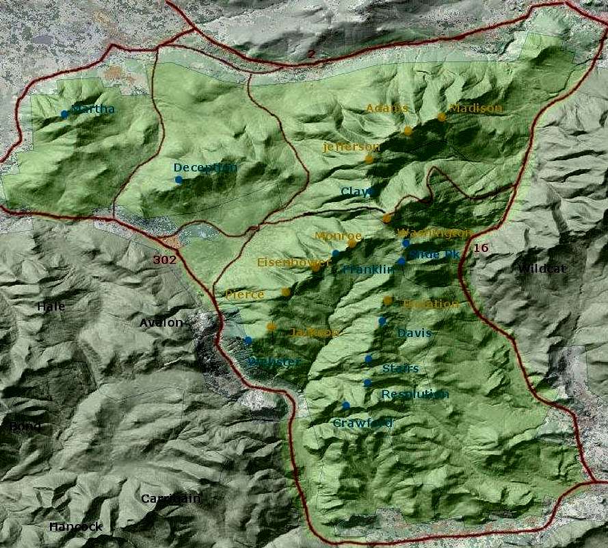
Interactive Map
See also the Google Maps Interactive map for the Presidential Range with links to the peaks that have pages on SP.
The Appalachian Mountain Club publishes the closest thing to an "official" list of New Hampshire mountains. To make the list, a mountain must rise at least 200 feet above its highest connecting ridge. The AMC-listed peaks are yellowish on this map, some other named peaks in the range are blue; mountains not part of the range are named in black .
Carte Intéractive
Voir aussi la Cartes Interactives Google pour la Chaîne présidentielle avec des liens vers les sommets qui ont des pages sur SummitPost. Le « Appalachian Mountain Club » maintien une liste -- considérée "officielle"-- des montagnes du New Hampshire. Pour paraître sur cette liste, une montagne doit dépasser de plus de 200 pieds (65m) le plus haut col qui la relie à une autre. Les sommets de la liste AMC figurent en jaune sur cette carte. D’autres sommets importants de la chaîne sont marqués en bleu; les montagnes qui ne font pas partie de la chaîne étant désignées en noir.
AMC listed peaks / Sommets selon la liste AMC
| name | elevation | description |
| Mt. Washington | 6,288' 1917m |
This is as high as it gets in the Northeast. Famous for bad weather. Ravines provide winter sport (ice climbing, skiing) for the hardy. In summer the auto road, the cog railway, and the eastern trails will all be crowded. Le plus haut sommet du Nord-Est. Célèbre pour son mauvais temps. Ses ravins sont utilisés par les plus téméraires pour les sports d'hiver (escalade de glace, ski). En été il y a foule sur la route pavée, le funiculaire, et les sentiers de l'est. |
| Mt. Adams | 5,799' 1760m |
Second highest mountain in the Whites Second plus haut des Blanches. |
| Mt. Jefferson | 5,712' 1741m |
Third-highest in the Whites. Caps Ridge Trail provides easy access in summer. Troisième plus haut des Blanches. L’été, Accès facile par le Caps Ridge Trail. |
| Mt. Madison | 5,366' 1636m |
Northern anchor of the chain and the usual starting point for one-day traverses. Ancre la chaîne au nord. Point de départ usuel de la traversée en un jour. |
| Mt. Monroe | 5,372' 1637m |
Joined to Mt. Washington at the Lakes of the Clouds, the fourth-highest peak in the Whites. Relié au Mont Washington aux Lacs des Nuages; le quatrième plus haut. |
| Mt. Eisenhower | 4,780' 1457m |
Though under 5,000 feet, this peak offers great above-treeline views. Malgré son altitude inférieure à 1600m, cette montagne offre des vues panoramiques au-dessus de ligne des arbres. |
| Mt. Pierce | 4,310' 1314m |
Southern endpoint of the "shorter" presidential traverse, the summit just reaches treeline. Crawford Path provides easy access. Terminus sud de la "petite traversée", le sommet dépasse de justesse la ligne des arbres. |
| Mt. Jackson | 4,052' 1235m |
Though below treeline, the summit has suprisingly good views, including north to Mt Washington. Bien qu’en dessous de la ligne des arbres, présente de surprenantes vues depuis le sommet, y compris vers le Mont Washington au nord. |
| Mt. Isolation | 4,003' 1221m |
The only 4000-foot peak in the Southern Ridges. Lives up to its name: not easy to reach from the road. Seul des crêtes du Sud à dépasser les 4000 pieds (1300m). Son nom n'est pas fantaisiste: pas aisé à atteindre depuis la route. |
Other Named Peaks / Autres Sommets
| name | elevation | description |
| Ball Crag | 6,112' 1861m |
New Hampshire's little-known "other 6,000 foot peak", a bump north of Washington's summit. Peu connu, "l'autre 6000 pieds" de New Hampshire est une petite bosse au nord du sommet de Mont Washington. |
| Nelson Crag | 5,635' 1718m |
Northern shoulder of Washington with an eponymous trail. Épaule au nord de Washington, avec un sentier éponyme. |
| Sam Adams | 5,585' 1702m |
Named for the revolutionary, not the beer. N’est pas inspiré de la bière, mais du révolutionnaire passionné (lequel aimait bien la bière). |
| Mount Clay | 5,533' 1686m |
Not an official 4,000-footer, and not a president either. Nommé à la gloire d’un légiste qui ne fût jamais président, n’est pas "officiellement" un 4000. |
| Boott Spur | 5,500' 1674m |
Southeastern shoulder with its own trail. Épaule au sud-est de Washington avec son propre sentier. |
| J. Q. Adams | 5,410' 1649m |
small but sharp peak between Adams' summit and the col to Madison Petit sommet pointu entre Adams et le col qui mène a Madison. |
| Abigail Adams | 5,355' 1630m |
Known as "Adams 4" until late 2010 Mieux connu sous le nom "Adams 4". |
| Mt. Franklin | 5,001' 1524m |
Easily spotted from some angles as a sibling to Mt. Monroe, but almost imperceptible on a topo as it fades into its sibling's southwest slope. Apparaît clairement sous certains angles comme la jumelle du Mont Monroe, mais difficilement perceptible sur carte topographique, noyé dans la pente sud-ouest de celle-ci. |
| Lion Head | 5,000' 1524m |
Well-known rock overlooking Tuckerman Ravine. Rocher bien connu qui surplombe le ravin Tuckerman. |
| Slide Peak | 4,806' 1465m |
a.k.a. Gulf Peak. Marks the head of the Gulf of Slides. Alias Gulf Peak. Marque la tête du Gulf of Slides (Golfe des Avals). |
| Mt. Webster | 3,910' 1192m |
True southwestern terminus of the Presidential Range, though under 4000 feet. Limited views. Terminus sud-ouest de la Chaîne Présidentielle, mais ne dépasse pas les 4000 pieds. Vues limitées. |
| Mt. Deception | 3,622' 1119m |
Totally trailless, rarely visited. N'a jamais connu de sentier, rarement visité. |
| Mt. Martha | 3,573' 1089m |
A favorite viewpoint onto other Presidentials. Populaire pour de belles vues sur les autres Présidentielles. |
| Mt. Crawford | 3,119' 951m |
One of the more accessible peaks on the Southern Ridges Un des sommets les plus accessibles des Crêtes du Sud. |
 |
 |
Getting There
from southwest
The Presidentials lie within a roughly triangular area bounded on the North by rte 2, on the East by rte 16, and on the southwest by rte 302. Most visitors take Interstate 93 north from Boston, then turn east either on the Kancamagus Highway (rte 112) [south of Franconia Notch] to reach rte 16, or on rte 3 [at the northern end of Franconia Notch] as a shortcut to rte 302 and/or route 2. Another option is to take Interstate 95 up the coast of Maine, then follow route 302 from Portland.
Comment y Aller
Les Présidentielles se situent dans une région à peu près triangulaire ( la route 2 au nord, la 16 à l'est et la 302 au sud-ouest). La plupart des visiteurs prennent l'autoroute 93 vers le nord depuis Boston, puis tournent vers l'est, par exemple sur la route 112. D'autres choisissent l'autoroute 95 qui suit la côte du Maine, puis tournent vers le nord-ouest sur la 302 à Portland. En partant de Montréal, prenez la 10, puis la 55 qui deviendra la 91, jusqu'à la 93. Ensuite prenez la 302 vers l'est.
Red Tape

Madison hut
WMNF parking $3/day at some trailheads. Some of the most popular trailheads (eg, Pinkham Notch, Crawford Notch) are in state parks and therefore free. Appalachia trailhead is just outside the WMNF limits and therefore free.
There's a deposit-box system for purchasing parking at the WMNF trailheads, or you can purchase annual or multi-day passes, which is much cheaper, from designated vendors.
On Mt Washington, the cog railway and the auto road are privately owned, and a fee is charged for their use.
Various rules restricting fires, camping, etc, especially in designated wilderness areas. In particular, the eastern side of Mt Washington is a no-camping zone, except for a few sites at Hermit Lake and Harvard Cabin. There is no camping above treeline (except on at least two feet of snow), and no camping within the boundaries of the state parks (except at designated campsites).
In general, hikers and campers in WMNF are expected to Leave No Trace.
Contraintes Réglementaires
Se garer dans la WMNF coûte $3 (US) par jour, mais les stationnements les plus fréquentés (Pinkham Notch, Crawford Notch) sont gratuits. Ils sont situés dans des parcs qui appartiennent au gouvernement de l'État. Le stationnement à Appalachia est également gratuit puisqu’il est, mais de justesse, en-dehors de la WMNF.
Un système de péage par enveloppe existe pour les parkings WMNF. Vous pouvez aussi acheter des permis a tariff reduit pour des périodes plus longues.
Sur le Mont Washington, le funiculaire et la route pavée sont privés, vous devrez donc payer pour vous en servir.
Il existe des règles [en anglais uniquement] concernant le feu, les tentes, etc., surtout dans les régions « wilderness » [sauvages] désignées par le service forestier. Sur de grandes étendues de ces montagnes, l’installation de tentes est défendue. Voir individuellement les pages montagnes pour plus de détails.
En général, les visiteurs à la WMNF sont priés de ne laisser aucune trace.
À noter que la quasi-totalité des habitants de la région sont unilingues anglais.
Huts, shelters, etc
The AMC High Mountain Huts are intended to be a day's hike apart from each other.
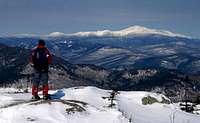
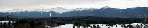
from the South in winter
| Name | Location | Capacity | Season |
| Madison Hut | ridge between Madison and Adams | 50 | June-Sept |
| Lake of the Clouds Hut | col joining Washington to Monroe | 90 | June-Sept |
| Mizpah Spring Hut | ridge south of Pierce | 60 | May-Oct |
See individual mountain pages for additonal info on other huts, shelters, and campsites, and backcountry camping rules.
In particular, see the Mt Adams page for links to the huts and shelters operated by the Randolph Mountain Club on that mountain, which are open year-round on a first-come basis. See the Mt Washington page for info on winter shelters including Harvard Cabin. (Note that the AMC runs a lodge in Pinkham Notch which they also call Harvard Cabin, but this should not be confused with the "real" Harvard Cabin in Huntington Ravine.) See the Mt. Eisenhower page for an overview of huts and shelters in the southern Presidentials. See the Mt Isolation page for info on shelters and campsites on the Southern Ridges.
Remember, the eastern side of Mt Washington is a no-camping zone, except for a few sites at Hermit Lake and Harvard Cabin. There is no camping above treeline (except on at least two feet of snow), and no camping within the boundaries of the state parks (except at designated campsites).
In general, hikers and campers in WMNF are expected to Leave No Trace.
Refuges, Abris, etc.
Les refuges de Montagne du AMC [Club de Montagne des Appalaches] sont sensés être à un jour de marche, l’un de l’autre.
(voir table ci-dessus)
Voir individuellement les pages montagnes pour plus d'informations sur d'autres refuges, abris et camping, ainsi que sur le règlement applicable au camping sauvage.
En particulier, voir la page du Mont Adams pour des liens concernant les refuges et abris gérés par le Randolph Mountain Club sur les flancs de cette montagne. Ces derniers restent ouverts toute l'année sur le principe du premier- arrivé / premier - servi. Voir la page du Mont Washington pour des informations sur les abris d'hiver, incluant Harvard Cabin. Voir la page du Mont Eisenhower pour un aperçu des refuges et abris dans le sud des Présidentielles. Voir la page du Mont Isolation pour des informations sur les abris et campings dans les Crêtes du Sud.
When To Climb
from the South in winter
Year round. Note that Mt. Washington's famous bad weather applies equally to all the higher peaks. Winter climbing requires extreme caution. The higher peaks of this range are practically the only area in New England where avalanches are common. See the links on the Mt Washington page for crucial information and forecasts. From December through June, check for road closures due to snow and mud.
Quand En Faire L’Ascension
Toute l'année. À noter que la réputation du Mont Washington pour le mauvais temps s'applique également à tous les hauts sommets. L’ascension hivernale nécessite des précautions extrêmes. Les hauts sommets de cette chaîne sont les rares endroits de la Nouvelle-Angleterre où les avalanches sont courantes. Voir la page du Mont Washington pour des informations et les prévisions de la plus haute importance. De décembre à juin, il faut prévoir des fermetures des routes causées par la neige et la boue.
Major Trails
This list is not exhaustive...
Ridge Trails
The Appalachian Trail follows the ridgeline over the entire group. More precisely speaking, the following trails form part of the AT (proceeding southbound):
- The Gulfside Trail links the summits of all the Northern Presidentials to the summit of Mt. Washington.
- Crawford Path links Mt Washington to the Southern Presidentials as far as Mt. Pierce.
- Below treeline, the Webster Cliff Trail takes up the relay to include Mts. Jackson and Webster.
Sentiers ImportantsCette liste n’est pas exhaustive...
Sentiers de Crêtes
L'Appalachian Trail (Sentier des Appalaches) suit la crête tout le long du groupe entier. A proprement parlé, ce sont les sentiers suivant qui constituent la A.T. (en partant au sud):
- ·Gulfside Trail joint les sommets de toutes les Présidentielles du Nord jusqu'au sommet du Mont Washington.
- ·Crawford Path joint le Mont Washington à la plupart des Présidentielles du Sud, s'arrêtant au Mont Pierce.
- ·Sous la ligne des arbres, Webster Cliff trail reprend le relais pour rejoindre Jackson et Webster en partant de Pierce.
| From West | |||
|---|---|---|---|
| Trail | To | Trailhead | Comment |
| Caps Ridge Tr. | Mt Jefferson | Jefferson Notch Rd | |
| Jewell Tr. | Mt Clay | Base Rd | |
| Ammonoosuc Ravine Tr. | Mt Monroe | ||
| Edmands Path | Mt Eisenhower | Mt Clinton Rd | |
| From Southwest | |||
| Trail | To | Trailhead | Comment |
| Crawford Path | Mt Wash. via Mt Pierce | Crawford Hostel (rte 302) | gentle trail facile |
| Webster-Jackson Tr. | Mt Jackson, Mt Webster | Rte 302 near Crawford Hostel | |
| Webster Cliff Tr. | Mt Pierce via Mt Webster | Rte 302 ~3 mi S. of the Hostel | part of the Appalachian Trail fait parti du Sentier des Appalaches |
| From South | |||
| Trail | To | Trailhead | Comment |
| Dry River Tr. | Mt Washington | rte 302 near Dry River Campgd. | crosses the Dry River Wilderness traverse la Dry River Wilderness |
| Davis Path | Mt Wash. via Mt Isolation | rte 302 | |
| From East | |||
| Trail | To | Trailhead | Comment |
| Glen Boulder Tr. | Boott Spur via Slide Peak | Glen Ellis Falls (rte 16) | |
| Boott Spur Tr. | Boott Spur | Pinkham Notch (rte 16) | |
| Tuckerman Ravine Tr. | Mt Washington | ||
| Great Gulf Tr. | Mt Washington | Camp Dodge (rte 16) | branch trails to all the north peaks sentiers rameaux pour tous les sommets du nord |
| Daniel Webster-Scout Tr. | Mt Madison | Dolly Copp Rd (south end) | |
| From Northeast | |||
| Trail | To | Trailhead | Comment |
| Pine Link | Mt Madison | Dolly Copp Rd (~midpoint) | |
| Howker Ridge Tr. | Dolly Copp Rd (north end) | ||
| From North | |||
| Trail | To | Trailhead | Comment |
| Valley Way | Mt Madison / Mt Adams | Appalachia (rte 2) | gentle and sheltered facile et abrité |
| Air Line | Mt Adams | scenic ridge route voie panoramique de crête | |
| Short Line | ravine route - avoid in winter ravin - à éviter en hiver | ||
| Lowe's Path | Lowe's Store (rte 2) | winter parking at store stationnement hivernal au magasin | |
| Castle Tr. | Mt Jefferson | Bowman (rte 2) | |
|
The Southern Ridges
[img:122952:alignright:small:Montalban Ridge]At least arguably, the Presidential Range includes a couple of long, mostly sub-4000-foot ridges that extend southward from Boott Spur and Slide Peak into and through the Dry River Wilderness (over a dozen miles). Hiking these isolated, wooded peaks is a very different experience from the alpine environments of the taller, more northerly peaks, and many hikers understandably feel that these southern ridges simply don't count. (The "presidential traverse" is hard enough without making a detour to include these.) Since these southern ridges are not convenient to the trails used for the "major" Presidential peaks, these ridges and the trails over them will be described in this separate section.
From Boott Spur and Slide Peak (aka Gulf Peak), two ridges lead southward on either side of the stream called Rocky Branch.
On the east side, the Rocky Branch Ridge, which connects to Slide Peak, heads south over a series of unnamed points to Engine Hill (3244') and Maple Mountain (2601'). Connected further east and southeast are Popple Mountain (2102') and Iron Mountain (2726'). With the exception of Iron Mountain, none of these peaks is reached by a trail. The Rocky Branch trail, which follows its eponymous stream until it turns East near Engine Hill, comes closest, except for a couple of unnamed points near Slide Peak for which the Glen Boulder Trail or the Isolation Trail may come closer.
On the west side of Rocky Branch, Montalban Ridge runs down the center of the Dry River Wilderness, and includes Mt Isolation (4003'), Mt Davis (3819'), Stairs Mountain (3463'), and Mt Resolution (3415'), at which point the ridge forks around Razor Brook. [img:122954:alignright:small:Rocky Branch valley]
The western branch of Montalban Ridge is called Bemis Ridge and passes over Mt Crawford (3119') and Mt Hope (2505') before terminating at Hart Ledge in the village of Sawyer Rock. Davis Path passes near the summit of Mt Crawford and continues over or near each peak of Montalban Ridge from Mt Resolution northward.
Mt Parker (3009') and Mt Langdon (2309') begin an eastern branch of Montalban Ridge, which continues east over some humps called "the Crippies" to Mt Pickering (1930') and Mt Stanton (1716') , terminating at Whites Ledge in the town of Cooks Crossing. From that eastern terminus, theMt Stanton Trail leads west over Mt Langdon to the Mt Langdon Shelter. There it is met by the Mt Langdon Trail from the south, and the Mt Parker Trail from the north. The latter trail passes over its namesake before meeting Davis Path on Mt Resolution.
Les Crêtes du Sud
On pourrait soutenir que la chaîne présidentielle comprend quelques longues crêtes, en grande partie inférieures à 4000 pied en terme d’altitude, et qui s'étendent vers le sud depuis Boott Spur, traversant la Dry River Wilderness (plus de 18 km). Ces collines boisées sont tellement différentes des environnements alpins de leurs voisins plus au nord, que beaucoup de gens estiment que les Crêtes du Sud « ne comptent tout simplement pas ». (Une «traversée présidentielle » est déjà suffisamment difficile sans faire le détour au sud.) Comme les Crêtes du Sud ne sont pas proches des sentiers normalement utilisés pour les sommets « remarquables» des Présidentielles, ces crêtes et les sentiers qui s’y trouvent sont décrits ici, comme une section à part.
À partir de Boott Spur et Slide Peak (également nommé Gulf Peak), deux crêtes partent ver le sud, chacune d'un coté du ruisseau appelé « Rocky Branch ».
A l’est du ruisseau, la crête Rocky Branch, qui commence à Slide Peak, part vers le sud par une série de petits sommets anonymes pour arriver à Engine Hill (942m) et à Maple Mountain (784m). On retrouve Popple Mountain (628m) et Iron Mountain (822m) plus à l’est et au sud-est. À l'exception de Iron Mountain, aucun de ces sommets n'est servi par un sentier. Le sentier Rocky Branch, qui suit le ruisseau du même nom avant de virer à l'est près de Engine Hill, est celui qui s’en approche le plus (exception faite de quelques bosses anonymes près de Slide Peak qui sont peut-être mieux approchées par les sentiers Glen Boulder ou Isolation.
A l’ouest du ruisseau Rocky Branch, la crête Montalban est au coeur du Dry River Wilderness. De nord au sud, ses sommets sont : Mt Isolation (1.213m), Mt Davis (1.160m), Stairs Mountain (1.053m), et Mt Resolution (1.037m). Ensuite la crête bifurque de chaque côté de Razor Brook.
La branche ouest de la crête Montalban s'appelle Bemis Ridge et comprend Mt Crawford (918m) et Mt Hope (749m), se terminant à Hart Ledge dans le village de Sawyer Rock. Le sentier Davis Path approche le sommet du Mt Crawford, puis continue ver le nord, surmontant (ou manquant de près) chaque sommet en commençant par le Mt Resolution et finissant sur le Mt Washington.
Mt Parker (909m) et Mt Langdon (723m) marquent le début de la branche est de la crête Montalbe. Elle continue par quelques bosses appelées "the Crippies" et passe par Mt Pickering (569m) et Mt Stanton (493m), pour se terminer à White's Ledge dans la ville de Cooks Crossing. Partant de ce terminus est, le sentier Mt Stanton se dirige a l’ouest parcourant le Mt Langdon en direction de l’abri Mt Langdon. Là, il croise le sentier Mt Langdon qui vient du sud, et le sentier Mt Parker qui vient du nord. Ce dernier surmonte son sommet éponyme avant de rejoindre Davis Path sur le Mt Resolution.
The Dartmouth Range and Cherry Mountain
Even more easily overlooked than the Southern Ridges is a western spur called the Dartmouth Range, joined to Mount Jefferson at Jefferson Col. The Dartmouth Range proper is entirely trail-less and not much visited, but an outlying group of peaks a bit further west, known collectively as Cherry Mountain, has trails, and the highest peak Mount Martha, is locally well-known for its views.
From east to west, the named 3000'+ peaks of the Dartmouth Range are:
Millen Hill (3355'), Mt. Mitten (3058'), and Mt. Deception (3671').
Crossing westward over Cherry Mountain Rd (about 2080'), the named peaks of Cherry Mountain are The Humps (3012'), Mt. Martha (3563'), and Owl's Head (3258'). (This Owl's Head should not be confused with the 4000-footer of the same name, nor with any of the four other Owl's Heads in New Hampshire.)
The Cherry Mountain Trail crosses Cherry Mountain from route 115 in the west to Cherry Mountain Road in the east, passing Mt Martha at the northern end of a mile-long dogleg on the way. The Owl's Head Trail climbs to Owl's Head and Mt Martha from the north, and the Black Brook Trail takes a fairly long approach from the south, joining the Cherry Mountain Trail just after that trail turns east again after its southern dogleg.
La Chaine Dartmouth et Cherry Mountain
Cette sous-chaîne de l'ouest, encore plus facile à ignorer que les Crêtes du Sud, rejoint le Mt Jefferson à Jefferson Col. La chaîne Dartmouth, strictu sensu, n'abrite aucun sentier et est rarement visitée, mais il y a un groupe de sommets plus à l'ouest, et collectivement appelés "Cherry Mountain", qui possède des sentiers. Son sommet le plus important, Mount Martha, est connu pour ses beaux panoramas.
D'est en ouest, les sommets de plus de trois mille pieds (~910 m) de la chaîne Dartmouth sont: Millen Hill (1.014m), Mt Mitten (921m), et Mt Deception (1.101m).
Traversant la rue Cherry Mountain Road vers l'ouest, les sommets baptisés de Cherry Mountain sont: The Humps (918m), Mt Martha (1.081m) et Owl's Head (993m). (Cet Owl's Head ne est pas à confondre avec l'Owl's Head de 4000 pieds, ni avec un des quatre autres Owl's Heads situés au New Hampshire.) Le sentier Cherry Mountain Trail traverse Cherry Mountain depuis la route 115 à l'ouest, jusqu’à Cherry Mountain Road à l'est, passant par le Mt Martha à l’extrémité nord d'un zigzag de 1,6km. Le sentier Owl's Head Trail monte l’Owl's Head et le Mt Martha par le nord, et le Black Brook Trail, suite à une assez longue approche par le sud, rejoint le Cherry Mountain Trail quand ce dernier tourne en direction de l'est après ledit zigzag.
Mountain Conditions
See the Mt Washington page for many useful links. BE PREPARED. fatalities in the Presidentials

The Presidential Range is home to the largest alpine zone in New Hampshire, and perhaps in the Eastern U.S. Wind conditions can be brutal, especially in the winter.
These harsh conditions give rise to an assemblage of flora and fauna more typical of arctic environments; many plants are rare or endangered in the lower 48. The most visible plants (not counting lichens) are usually Bigelow's sedge, Highland rush, and dwarf heath, but in season it is hard to miss the diapensia, moss campion, mountain sandwort, and cinquefoils. Keep an eye out for a drab-looking nymphalid butterfly visiting these flowers: it may be the "White Mountain arctic" subspecies of Oeneis melissa, endemic to Presidential Range.
La Chaine Presidentielle contient la plus large zone alpine du New Hampshire, et peut-etre dans l'est des U.S.A. On y rencontre souvent un vent brutal, surtout en hiver.
Ces conditions severes font naitre une assemblee de flore et de faune qui ressemble au type arctique; plusieurs plantes sont rares ou protegees dans les 48 Etats "bas". Les plantes les plus visibles (excluant les lichens) sont normalement la laiche de Bigelow, le jonc "highlands", et des bruyeres, mais saisonnalement on ne risque pas de manquer la diapensia, la silene acaule, la minuartia groenlandica, et les potentilles. Regardez bien ce papillon nymphalide peu colore: c'est peut-etre un sous-espece de Oeneis milissa, endemique a la Chaine Presidentielle.
Maps & Guidebooks
For the White Mountains generally, the "hiker's bible" is:
AMC White Mountain Guide, $22.00. Includes trail descriptions and topographic maps (on paper).
You can also order tyvek versions of the maps separately for $24.00.
The AMC also publishes books and maps focusing specifically on the Presidential Range. (I haven't tried them personally).
Mt Washington & Presidential Range Trail Guide $16.95
Presidential Range topo map (Tyvek) $7.95
The trails in the northern presidentials are maintained by the Randolph Mountain Club. The trails are so numerous you might want to go to the horse's mouth for a detailed guide:
Randolph Paths $17.00, including the
trail map, available separately for $6.00
Technical climbers and skiers (or map lovers) may be interested in a very fine-scale map of Mt Washington and surroundings (eg, showing the details of the ravines):
the Washburn map (paper) $10.95.
Online maps are also helpful. My current favorite source is Cal Topo. Caution: topo maps found online are usually scans of paper maps and are often decades out of date. Just because a bridge or a hut or even a trail is shown on the map, doesn't always mean it still exists on the ground.
Please Comment on this page if you know of a good book or map to include.
Livres et Cartes
(voir ci-dessus pour les livres et cartes en anglais).
Please Comment on this page if you know of a good book or map to include.
Livres et Cartes
(voir ci-dessus pour les livres et cartes en anglais).
Des cartes en lignes sont disponibles chez Cal Topo entre autres. Avertissement: les cartes topos que l'on trouve en ligne sont souvent obsoletes. Verifiez l'existence actuelle de cette cabane / ce pont / ce sentier...
Veuillez me contacter si vous connaissez un bon livre ou une bonne carte (en francais surtout) a ajouter a la liste.
Other Books
Not Without Peril ISBN: 1-929173-06-7 . Detailed accounts of accidents and incidents in the Presidential Range.External Links
- Chauvin Guides' Winter Traverse Page
Detailed gear lists, maps, etc for a winter traverse. WARNING: these lists are no substitute for judgement and experience. A Presi traverse in winter is as serious as mountaineering gets in New England. If you're the least bit unfamiliar with any of the equipment, or uncertain of your ability to predict avalanches, do not attempt this without a guide.
(Thanks to Adventurer for mentioning this link.) - Ellozy's Presidential Traverse FAQ
The definitive guide to the Presidential Traverse