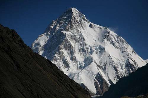
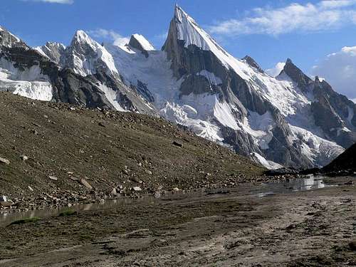
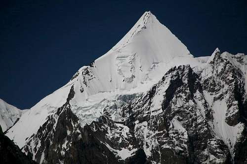
Baltistan covering an area of 26,000 square kilometer, comprises 5 valleys: Skardu, Khaplu, Shigar, Kharmang and Rondu. The Baltistan is the part of Gilgit Baltistan, Pakistan. These valleys are very important from the mountaineering, trekking and mountain related adventure activities. The northern territory of Baltistan contains four peak above 8000 meters, such as K-2 (8611-M) (Second highest mountain in the world), Gasherbrum-I (8068-m), Broad Peak (8048-m), and Gaserbrum-II (8035-m), and many other above 7000 meters peaks, such as Masherbrum, Gasherbrum-IV, Muztagh Towers, Latok, Baintha Brakk, Chogolisa, Baltoro Kangri, and many more.
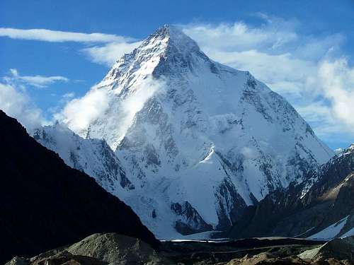
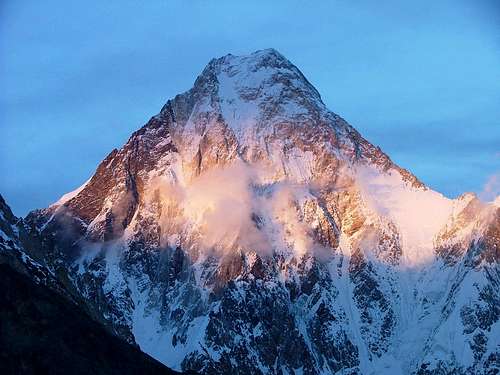
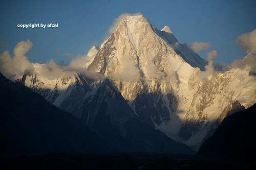
K2
Since time began, Baltistan has remained isolated from the rest of the world. It was first mentioned in the annals of an AD 747 Chinese military expedition to aid Ladakh against a threatened invasion from Tibet. Fascinated, the ancient Chinese geographers named it the “Tibet of the Apricots”, because of the abundance of this fruit that grew there, and still does. Long a Buddhist country, Islam was embraced in the fifteenth century and during the Mughal era it was annexed to India. But when Aurangzeb died it soon reverted to its isolated, independent ways, only to come under a succession of local rulers, Dogra, Sikhs and Afghans, finally coming into the Kingdom of Kashmir. At independence in 1947, However, Baltistan chose to join Pakistan, and now the Baltistan is the Part of Pakistan.
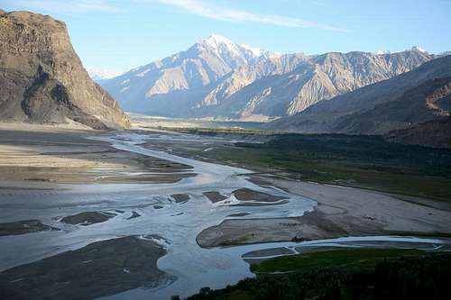
Within fifteen minutes of taking off from the Islamabad Airport, in PIA scheduled flight, we will be in a virgin world snaking through mountain passes and following emerald ribbons of rivers, the plane will be often lower than the level of the treacherous road. Every turn will brought a breathtaking new vista, and as we will leave habitation behind, we will enter a forest of peaks and nature of such staggering perfection that it flooded one simultaneously with a soaring joy and a stark realization of the absolute insignificance of man. Leaving the plain, the most immediate impression is that of disorientation. The valley and the rock and the desert plains have no likeness to any other landscape, as if the Sahara had been dropped down between massive walls of rock. There are no perspectives. So complete is the circle of mountains everything narrow and the eye is ever confused. Lying within this ring of 5000 meters high mountains that glimmer through the haze in varying shades of purple, grey, and ochre, the jade river Indus snakes sinuously between the ribboned, wind-blown sand dunes close beneath a 200 feet high island of massive rock. It’s here that Skardu straggles along the plateau.
From Islamabad most of the Climbing expedition teams, trekking parties and other visitors like to travel on Karakoram Highway. Not until 1978, with the completion of the 170 kilometers long Gilgit-Skardu Road, did Baltistan have any permanent access to the rest of the world, even in 1980s the citizens retained their self-sufficiency and independence, aloof from the twentieth century and its wonders. So formidable in the scale of its colour and texture, savagery and desolation is the Indus gorge out of Skardu that not even Balti’s ventured to cross it. The road to Skardu is one of the most dramatic roads in the world, following the narrow, dark, bleak, and stupendously high ravine of the Indus for mile after mile. Never a blade of gross relieves the monotony of the hostile rock. Only the jade green river, tumbling and foaming in stretches of white water, relieves the grey, brown, sere, and unrelenting walls of boulders- strewn rock, and cliffs. Like its larger sister, the Karakoram Highway, it represents one of the world’s major feats of civil engineering construction and already Skardu, long a Mecca for the high altitude mountaineers, have become a major tourist resort as the coaches, cars, and jeeps flood down the road across more than 20 bridges to the town.
No diminutive this, though Baltistan, crowned by the Majesty of K-2, at 8611 meters the world’s second highest mountain, sit an average high of 4500 meters. No relief map or guide book can lead you through this wilderness of lost horizons. There are none. The horizon merge in a tumultuous maze in which west and east, north and south, lurch giddily from one side of the eye to the other in utter confusion.
The Skardu is the capital city of Baltistan. Its real attraction is as gateway to the grandest sight in all nature, Concordia, the amphitheater of the ten of the world’s thirty greatest mountains, the adjacent glaciers and peak, and its closeness to Lake Satpara, one of the hidden pearls of Baltistan.
At 2314 meters and due to confluence of the Indus and Shigar rivers, this is the capital town of the Baltistan. It has a pleasant climate has been the capital for a long time. In summer dusty winds frequently arise during the afternoon and continue till evening. Scattered among the apricots trees, poplars, willows and bushes are the residences, Government Offices, Banks, hospital, mosques, places, shops, markets and hotels. The shops and markets sales the food items, camping equipments, fur toques, Karakul fez, turbans and flowing togas of rough wool worn by the local inhabitants. Mountaineering and Trekking parties arrive here, stay for a short period and leave as quickly as possible for the mountains. The airport is situated 16 kilometer south-west of the Skardu. The most important monuments in the region is the rock carving of Buddha, some one and half kilometer south on the road to Satpara. It dates back to the 10th century AD. The entire surface of the rock, 8 meter high and some 5 meter wide, is carved with great imagination and skill. At 15th century aqueduct located in the town is an interesting feature to see. The fort of Kharpochu, which stands high up on the rock of Skardu, overlooks the streets of the town. Hotels for tourist are available, as there are many hotels. International/domestic telephone calls are available. The internet facilities are also available.
While waiting for a flight, bus, jeep or car, worthwhile diversions include. Going around the eastern end of the Skardu Rock, you come to village of Narsok, where a pure spring emerges from the base of a monolithic rock. The ascent of Skardu rock is quite tough. From Skardu fort there is an extended view over cultivated fields and the Indus River below. Lake Satpara is about 6 kilometers south-west of the Skardu.
KHAPLU
At 2355 meter, this historic town lies on the south side of the Shyok River, among innumerable trees on a fertile alluvial plain. The Khaplu is the District Headquarter of the Ganchee District. Facilities include a rest house, shops, and a few hotels and telephone. It is about 103 kilometers east of Skardu and can be reached by bus, van, jeep and car. The ever changing landscapes follow the sandy valley floor, black mountains reflecting in the waters of the Shyok River. On the slopes, little communities have carved their terraced fields and homes out of the mountainside, diverting the waters along a network of ancient irrigation aqueducts.
The capital of this valley, distinctively Tibetan in its people and architecture, is spread out along the greenest and broadest bowl of the valley, an arena that for the non-trekker is the key point to of the entire visit to Baltistan. For only in Khaplu, so high and close together are the regions other valleys, do you catch sight of “raison d’ etre” for any visit to Baltistan, its mountains. Here, in the early morning, as the sun slopes above the eastern horizon, its rays burst in a dazzling shower of diamonds on the scintillating peak of mighty 7821 meters high Masherbrum.
Khaplu town is the historic base of many voyages of exploration to the mountains in the region of the Karakoram. G.T.Vigne, after whom one of the glaciers south of Concordia is named. had ascended the Saltoro valley from Khaplu in 1838 in his search for the Saltoro Pass. Some 70 years later the great Tom Longstaff, accompanied by Arthur Neve and A.M. Slingaby, repeated the journey and found the pass at the head of Bilafond glacier; they then crossed and descended to the Siachen glacier. And it was from Khaplu that James Waller in 1935 with John Hunt and four others reached the Kondus valley and made an attempt to climb Saltoro Kangri (7742-m). Waller returned in 1938 with Graham Brown and two others, ascended the Hushe valley and pitched a base camp at the junction of the two torrents draining the Masherbrum and Gondogoro Glacier, from there they attempted to ascend Masherbrum (7821-M) from the South. These valleys and glacier areas had also benn visited from Khaplu by the Workmans in 1911 and 1912.
Khaplu today is still the gateway to many adventurous treks, most of which lead to the north side of the Shyok River. The river is crossable from Khaplu by a jeep. The other bridge is located some 10 kilometer east of Khaplu, a little beyond Surmo where the Shyok valley floor narrows down considerably. The walk to Surmo along the river bed is quite easy. The Saling Bridge and Surmo bridge are the only other ways to approach the valley of Hushe, Saltoro, Dansum, etc. It incorporates many famous passes such as Masherbrum La and Gondogoro la.
SHIGAR:
At 2316 and some 32 kilometers from Skardu, Shigar is picturesquely set in a lush green valley and enjoy a pleasant climate. The town is not only greener and richer than Skardu, but it has appearance of being older. Shigar was once the capital of a strong local Raja and its fortress was a symbol of his power. Games of Polo and archery were frequent. One can still see several old houses with beautiful architectural designs. There are a few mosques built in Tibetan style, which carved panels round the wooden doors. A few shops built of wood comprising the bazaar are found near the mosque. The houses of old Shigar are build distinctly in Tibetan style. The modern buildings, such as hospital, rest house, government staff quarters, etc are built round old Shigar. Ancient Buddhist settlements dating back to the 8th and 10th centuries have been discovered here recently; they contain a monastery and thousands of inscriptions and rock carvings. The discovery of a Chinese pagoda with inscriptions indicates friendly relation with China in olden days.
Shigar is the gateway to many adventurous treks that lead over famous glaciers and the base of numerous high peaks. The wide Shigar valley is formed by the confluence of the Braldu and Basna rivers, about 33 kilometers upstream from Shigar. It is watered by several great glaciers such as the Baltoro, Biafo Chogo Lungma, Panmah and Chogtoi; and this vast region contains 5 of the world’s highest peaks, K-2, the Gasherbrum group, Broad Peak and Masherbrum are some of them. It incorporates many famous passes such as, Sokha La, Skam La, Hisper Pass, Naushik La, Braldu La, Sim La, Muztagh Pass and Gondogoro la. Once frequented by local people and traders. Some of passes have become strictly technical ascent or have gone out of use due to the melting, cracking or other changes in the pattern of the glaciers.
The best way to reach the town from Skardu is to hire a Car, Jeep or van. There are clean and comfortable hotels, rest house and camping site for stop-lovers.
Peaks in Baltistan Pakistan
8000 METER PEAKS IN BALTISTAN
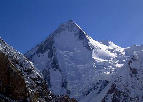
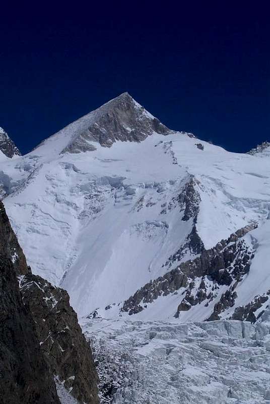
S.No Name of the Peak Height in Meters 01 K-2 8611 02 Gasherbrum-I 8068 03 Broad Peak 8047 04 Gasherbrum-II 8035
K-2
Broad Peak
Gasherbrum-I
Gasherbrum-II
G2 & G4
7000 METER PEAKS IN BALTISTAN
S.No Name of the Peak Height in Meters LOBSANG GROUP 01 Muztagh Tower 7284 02 Muztagh Tower 7279 LATOK GROUP 03 Baintha Brakk (M) 7285 04 Latok-I 7145 05 Latok-II 7108 06 Latok(I-W) 7100 K2 GROUP 07 Skyang Kangri (I) 7357 08 Skil Brum 7350 09 Skyang Kangri (II) 7345 10 Summa Ri 7286 BROAD GROUP 11 Broad Peak (N) 7387 GASHERBRUM GROUP 12 Gasherbrum-III 7952 13 Gasherbrum-IV 7925 14 Gasherbrum (E) 7772 15 Gasherbrum (N) 7500 16 Un named Peak 7310 17 Gasherbrum (V) 7133 18 Gaserbrum (V-MD) 7120 19 Gasherbrum (SW) 7069 20 Gasherbrum-VI 7004 SIA GROUP 21 Sia Kangri 7422 22 Sia Kangri-II 7325 23 Sia Kangri-IV 7315 24 Sia Kangri-III 7273 CHOGO LUNGMA GROUP 25 Spantik 7027 MASHERBRUM GROUP 26 Masherbrum (E) 7822 27 Masherbrum (W) 7806 27 Yermand Kangri 7163 28 Mandu Peak (E) 7127 29 Mandu Peak (W) 7081 CHOGOLISA GROUP 30 Chogolisa (SW) 7668 31 Chogolisa (NE) 7654 32 Baltoro Kangri 7300 33 Baltoro Kangri (II) 7270 34 Baltoro Kangri (IV) 7265 35 Ice Dom 7150 SALTORO GROUP 36 Saltoro Kangri (I) 7742 37 Saltoro Kangri (II) 7705 EAST OF HUSHE VALLEY GROUP 38 K-6 (W) 7100 39 Link Sar 7041 40 Link Sar (N) 7000
Gasherbrum-IV
6000 METER PEAKS IN BALTISTAN
S.No Name of the Peak Height in Meters 01 Baintha Brakk (SE) 6960 02 Latok-III 6946 03 Baintha Brakk-II 6600 04 Baintha Brakk-III 6500 05 Latok-IV 6456 06 Latok (IV-SE) 6450 07 Uzun Brakk 6422 08 Bullah 6294 09 Choricho (M) 6756 10 Choricho (III) 6643 11 Choricho (II) 6631 12 Payu 6610 13 Uli Biaho (I-SW) 6417 14 Uli Biaho (I-NE) 6408 15 Choricho (IV) 6400 16 Uli Biaho-II 6353 17 Uli Biaho Tower 6109 18 Haina Blak Tower 6000 19 Unnamed Peak Paiyu Group 6000 20 Unnamed Peak Payu Group 6000 TRANGO GROUP 21 Kruksum (S) 6650 22 Kruksum (N) 6600 23 Trango Ri (II) 6545 24 Trango Ri (I) 6452 25 Kruksum (E) 6300 26 Trango Ri (III) 6300 27 Trango Ri (IV) 6300 28 Great Trango (I) 6286 29 Nameless Tower 6239 30 Great Trango (II) 6237 31 Great Trango (III) 6231 32 Munk 6150 LOBSANG GROUP 33 Biale 6729 34 Black Tooth 6719 35 Biange 6431 36 Lhunkgka Ri 6307 37 Unnamed Peak 6300 38 Biange Peak 6271 39 Lobsang 6225 40 Un named Peak 6100 41 Un named Peak 6085 42 Un named Peak 6050 43 Un named Peak 6050 44 Un named Peak 6040 45 Un named Peak 6024 45 Un named Peak 6020 46 Un named Peak 6007 47 Un named Peak 6001 48 Un named Peak 6000 K2 GROUP 49 Un named Peak 6940 50 Un named Peak 6859 51 Angel 6858 52 Un named Peak 6820 53 Un named Peak 6800 54 Un named Peak 6700 55 Un named Peak 6640 56 Un named Peak 6406 57 Nela peak 6394 58 Un named Peak 6379 59 Un named Peak 6350 60 Moni Peak 6300 61 Marble Peak 6256 62 New Cristal Peak 6252 63 Cristal Peak 5913 64 Un named Peak 6100 65 UN-named Peak 6060 66 Steste Peak 6001 BROAD GROUP 67 Un named Peak 6934 68 Un-named Peak 6913 69 Un named Peak 6806 70 Un named Peak 6806 71 Un named Peak 6805 72 Un named Peak 6700 73 Un named Peak 6450 74 Un named Peak 6444 75 Un named Peak 6394 GASHERBRUM GROUP 76 Un named Peak 6984 77 Gasherbrum(V-NW) 6980 78 Gasherbrum (V-N) 6950 79 Un named Peak 6936 80 Gasherbrum Twins 6912 81 Gasherbrum (V-E) 6900 82 Un named Peak 6753 83 Un-named Peak 6600 84 Un-named Peak 6550 85 Un named Peak 6218 SOUSBAN GROUP 86 Ganchen 6462 87 Susban Brakk 6413 88 Hikmul 6300 89 Un named 6123 90 Un named Peak 6066 91 Gama Soka Lumbu 6282 92 Un named Peak 6000 KHOSER GUNGE GROUP 93 Khoser Gunge 6401 MANGO GUSOR GROUP 94 Mango Gusor 6288 MASHERBRUM GROUP 95 Biarchedi (I) 6810 96 Biarchedi (II) 6781 97 Biarchedi (III) 6710 98 Biarchedi (IV) 6650 99 Serac Peak 6614 100 Hunch Back 6400 101 Biarchedi (V) 6362 102 Un named Peak 6350 103 Urdukas Peak (I) 6320 104 Un named Peak 6300 105 Urdukas Peak (II) 6280 106 Un named Peak 6279 107 Un named Peak 6251 108 Un named Peak 6250 109 Biarchedi (VI) 6236 110 Un named Peak 6200 111 Un named Peak 6170 112 Urdukas Peak (III) 6130 113 Un named Peak 6100 114 Un named Peak 6095 115 Biarchedi ((VII) 6010 116 Un named Peak 6030 117 Mitre Peak 6025 118 Un named Peak 6000 CHOGOLISA GROUP 119 Kaberi Peak 6950 120 Khumul Gri 6851 121 Kondus Peak 6750 122 Khumul Gri (II) 6706 123 Un named Peak 6700 124 Khumul Gri (III) 6674 124 Tasa Brakka 6600 125 Un named Peak 6600 126 Un named Peak 6600 127 Pioneer Peak 6550 128 Khumul Gri (VI) 6350 129 Laila 6096 DANSAM GROUP 130 Dansam 6666 131 Un named Peak 6450 EAST OF THALLE VALLEY GROUP 132 Honboro 6459 133 Un named Peak 6100 134 Un named Peak 6000 EAST OF HUSHE VALLEY GROUP 135 K-7 6934 136 Un named Peak 6858 137 Un named Peak 6568 138 Kapura 6544 139 Un named Peak 6500 140 Changi 6500 141 Drafey Khar (Drifka) 6444 142 Un named Peak 6400 143 Un named Peak 6325 144 Namika 6295 145 KHURDOPIN GROUP 146 Lakpe Lawo Brakk 6593
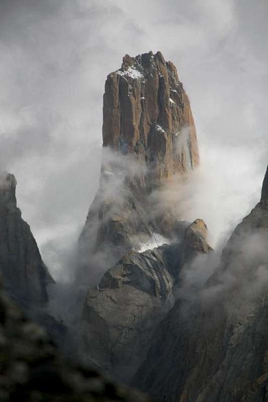
Trango Nameless Tower
Marble Peak
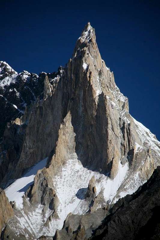
Laila Peak
Angel Peak
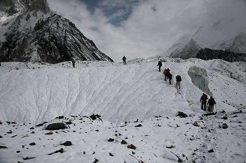
Treks in Baltistan
TREKS IN BALTISTAN
1-BALTORO-GONDOGORO-HUSHE: Askole- Concordia, K-2 B.C, Gasherbrum B.C, & return by the same route, or cross Gondogoro Pass or Vigne Pass, K-7 B.C, Skardu or vice versa Restricted Zone: Trekking Permit is required from Ministry of Tourism Islamabad.
2-BALTORO-MASHERBRUM PASS-HUSHE: Skardu-Askole-Concordia, K-2 B.C, Gasherbrum B.C, Masherbrum Pass, K-7 B.C,-Hushe-Skardu or vice versa Restricted Zone: Trekking Permit is required from Ministry of Tourism Islamabad.
3-PANMAH GLACIER – SIM PASS: Skardu-Panmah Glacier-Chring Glacier-Drenmang Glacier-Nobande Sobande Glacier-Simgang Glacier-Chaktoi Glacier-Sim Pass-Simgeng Glacier-Snow Lake& down to Askole via Biafo Glacier or to Nagar via Hispar Glacier, or vice versa. Restricted Zone: Trekking Permit is required from Ministry of Tourism Islamabad.
4-HISPAR PASS: Skardu-Askole-Biafo Glacier-Snow Lake-Hspar Pass-Hisper Glacier-Nagar-Gilgit or vice versa Open Zone: No Trekking Permit is required.
5-LUKPO PASS: Skardu-Askole-Biafo Glacier-Snow Lake-Simgang Glacier-Lukpo Pass-Braldu Glacier-Shimshal Pass-Shimshal village-Gilgit or vice versa Restricted Zone: Trekking Permit is required from Ministry of Tourism Islamabad.
6-SOKH PASS: Skardu-Askole-Biafo Glacier-Snow Lake-Sokh La-Sokh Glacier-Sosbun Glacier-Hikmul Pass-Hoh Lungma Glacier-Arandu-Skardu or vice versa. Open Zone: No Trekking Permit is required.
7-HARAMOSH PASS: Skardu-Arandu-Chogo Lungma Glacier-Haramosh La-Dache-Sassi-Gilgit or Skarduor vice versa. Open Zone: No Trekking Permit is required.
8-STAK PASS: Skardu-Stak-Stak Pass-Ganto Pass-Arandu-Chogo Lungma Glacier-Hramosh Pass-Sassi-Skardu or Gilgit or vice versa. Open Zone: No Trekking Permit is required.
9-SOSBUN VALLEY: Skardu-Chakpong-Ho-Sosbun B.C,-Sosbun Brakk B.C,-Hoh Lungma Glacier-Hikmul Pass-Doko-Skardu or vice versa. Open Zone: No Trekking Permit is required.
10-SKORO PASS: Skardu-Askole-Skoro Pass-Shigar-Skardu or vice versa Open Zone: No Trekking Permit is required.
11-THALEE PASS: Skardu-Shigar-Thalle Pass-Bukma-Doghani to Hushe or Skardu or vice versa. Open Zone: No Trekking Permit is required.
12-HUSHE VALLEY: Skardu-Hushe-Masherbrum B.C,-Shaicho-Gondogoro B.C,-K-7 B.C,-Hushe-Skardu or vice versa. Restricted Zone: Trekking Permit is required from Ministry of Tourism Islamabad.
13-HUSHE-ALING: Skardu-Hushe-Aling Glacier & back to Hushe via same route Open Zone: No Trekking Permit is required.
14-ACROSS DEOSAI: Skardu-Deosai Plateau-Chillim-Astore-Gilgit or vice versa Open Zone: No Trekking Permit is required.
What great country. Your writings are excellent, the history is very informative and the photos are second to none. I look forwards to reading your articles in the future as well. Thank you for showing us your country!
Thank you very much for reading of my Baltistan article. Thanks for kind words about my homeland. Best regards, Afzal
Jebentiboga35 - Oct 12, 2010 10:23 am - Hasn't voted
Home sickness...
Looking at this marvellous portfolio I felt a kind of homesickness, remembering the trekking in Baltistan, Aug-Sept 2000 with my son & some kind people from Hushe...
Pity the time is running away so fast....
Paolo M. - Milan (Italy)
I just discovered this amazing article this morning. On this rainy day it definitely made me feel amazingly better... :)
You are living in really magical place.
Thanks Afzal!
This is one of the major landmark articles in SP and a 'must' for anyone visiting Baltistan. Takes me back 23 years to when I came to the area in 1987 - and reminds me not just of Broad Peak (on which we reached 7200m), but of the fantastic journey to reach it - the KK highway, Nanga Parbat across the desert, the fantastic road through Indus Gorge... then Skardu - camped in your colleague Mohammed Iqball's garden... he showed us how if you spray a little water onto the barren ground, within 24 hours there was a vigorous growth of flowers! And then of course the fantastic journey onwards - by Jeep to Dassu - and then on foot the stunning 150km or so, to Concordia & Broad Peak Base.
As an aside, my imagination was captured by Laila Peak - partly because my wife is called Leila. Reminded me that although I saw a lot in 1987, there was so much I didn't see. I'd love to come back one day - and bring Leila with me - before we get too old!
Thanks again Afzal - best wishes, Mark
Thank you very much Mark! for your kind and valuable comments about my homeland. At the moment my colleague Iqbal is in Baltistan, and I will surely convey your this message to him. At the time of your travel the starting point of trekking was Dassu, but now the road up to Askole is constructed. Now the starting point is trekking Askole village.
Leila or Laila peak is really a very beautiful peak in Karakoram. I hope you have seen my many photos of Laila Peak at SP. Nice to hear that your wife is called "Leila". Please convey my best wishes and regards to your wife. I hope to meet you both in Pakistan in near future and hope you will enjoy your trip of Pakistan very well.
we are always ready to welcome our friends, we take friends to their hearts and take utmost responsibility as well to make them feel at home.
Thank you very much Mark for your kind and valuable comments on Baltistan article.
Best regards, Afzal
Thanks again Afzal - and thanks indeed for your welcome and friendship if we manage to come to Pakistan. I should love to come and show my wife, but it may be a few years before that particular dream comes true.
In the meantime I shall have to enjoy your photos - and the news you bring of how things have changed! I can scarcely believe that there is a road now, all the way to Askole. What a fantastic acheivement! I remember from 1987 that it was pretty rough getting to Dasso, but beyond there was the famous Braldu Gorge - challenging enough just on foot. If we make it out to Baltistan one day, then I would have to come and see the road through there.
Best wishes, Mark
Thanks again Mark - for your reply. You can see the Askole road photo by visiting the following link:
http://www.summitpost.org/approching-to-askole-karakoram-baltistan/387890/c-564135
With best wishes and regards, Afzal
Very good article.
The mixture of Tibetan culture&architecture in Baltistan is very interesting indeed.
Sounds like a fascinating area, mountains and culture alike.
Thank you very much Tim! for reading of my article. Deep in the heart of Karakoram Mountains, nestled in Pakistan's northeastern most corners, lies the small region of "Baltistan". The Capital town Skardu is the starting point for some of the best trekking and mountaineering in the world. A high altitude desert, bisected by the mighty Indus River, Baltistan is an area of extreme geographical conditions. Elevation rise from 2200m to 8616 at the top of K2. Summer in Baltistan is pleasant, yet with strong winds sweeping across the Indus Valley, while winters are harsh and cold, leaving the region isolated and mostly snowbound.
Baltistan A land still ruled by the nature. The Spirit of Baltistan, however, is the "Balti people & their culture". While Baltis have been a strictly Islamic people for over 500 years, Buddhism influenced the Baltis under Tibetan rule long before. Their language, remains an archaic dialect of classical Tibetan. During the Maqpon dynsty (Balti rulers) of the 16 & 17th centuries, the Balti-Pa were a nation led by potent Rajas who ruled a powerful kingdom. Today, the Baltis are a peaceful people, leading a simple rural life in harmony with their environment.
Thanks again for your visit and vote to my Baltistan article.
Best regards, Afzal
well done mr. Afzal your article is very excellent and in detail,it is also very helpful,for the people who wants to visit pakistan,your article realy potrait the beauty of pakistan.
best wishes
keep promoting pakistan
Incredible region, thoroughly documented in enjoyably descriptive terms. Loved your loose use of "cannonball" adjectives--made me think I was in the Grand Hall in the Wizard of Oz movie, such is the grandeur and pomp you present so well. Simply must read it again. Thank you sir. So happy to share your zeal for the enrapturing heights.
Children refers to the set of objects that logically fall under a given object. For example, the
Aconcagua mountain page is a child of the 'Aconcagua Group' and the 'Seven Summits.' The
Aconcagua mountain itself has many routes, photos, and trip reports as children.


Comments
Post a Comment