
-
 16341 Hits
-
 74.01% Score
-
 4 Votes
|
|
Mountain/Rock |
|---|---|
|
|
44.21666°N / 73.76512°W |
|
|
Essex |
|
|
Hiking |
|
|
Spring, Summer, Fall, Winter |
|
|
2440 ft / 744 m |
|
|
Overview
Baxter Mountain is one of the "little gems" of the Adirondack High Peaks area. Why would you want to climb a paltry 2440-foot peak when so many taller mountains beckon? For the effort this mountain has some of the finest views in the Adirondacks. The summit is mostly open ledges which provide great views in most directions. The mountain provides a unique perspective of looking straight up the John's Brook Valley to Mount Marcy, the highest peak in New York.The primary image shows Baxter Mountain as the lower ridge to the right of the prominent roadway (Rt. 9N), taken from the summit of nearby Owl's Head.
 John's Brook Valley and Mt. Marcy from Summit
 Dix from Summit
 Keene Valley from Summit
 Baxter Summit Fall Foliage
 Green Mountains from Summit
Getting There
These directions are to the Spruce Hill trailhead, which is easiest access to the mountain. From Rt. 73 either 2 miles south of Keene or 3 miles north of Keene Valley turn East on Rt. 9N. Drive 2.0 miles. The trailhead is near the top of the hill on the right, across from Hurricane Road, and is well marked. There is parking available at the trailhead.Routes also exist from the Keene Valley side.
 Trailhead
Red Tape
Trails pass through private land. Please respect landowner rights by not camping, littering, or lighting fires.Route
The trail from Rt. 9N starts very gradually and is only 1.1 miles and 770 feet of climb to the summit. The first 0.7 miles employ something found only very occasionally in the Adirondacks...switchbacks! At 0.7 miles you will reach a trail junction with the routes coming in from the Keene Valley side.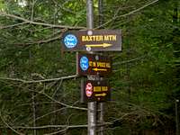 Trail Junction
The last 0.4 miles of trail ascends moderately to the summit ledge system and great views. This hike should only take 20-30 minutes in one direction.