
-
 11065 Hits
-
 90.81% Score
-
 33 Votes
|
|
Mountain/Rock |
|---|---|
|
|
37.32923°N / 118.75734°W |
|
|
Hiking, Mountaineering, Trad Climbing, Scrambling |
|
|
Spring, Summer, Fall |
|
|
12563 ft / 3829 m |
|
|
Overview
The gap between Bear Claw Spire also known by "Treasure peak," and Spire peak serves as a grand entrance into the Royce lakes area. Past this entrance a magnificent view opens up. A hiker walks in and faces the Royce Lakes, Feather peak, Royce peak, and Merriam peak-some of the best looking 13ers in CA, with classic snow, rock and ice routes available. These peaks are usually climbed in combination with Bear Claw Spire. Merriam and Royce peak
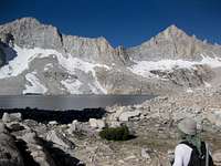 Royce and Feather peak
Amazing view from bellow Bear Claw Spire equals to a stunning panorama from the top of this rarely climbed gem. In addition, the climbers are challenged by a 4th class summit block, half of which is overhanging and appears as if it could collapse any second (but don't be afraid, it's been there for years and is there to stay).
Getting There
This peak may be accessed from different directions, but the trailhead that provides direct access would be Pine Creek. It is located several miles in from the town of Rovana (along US 395)North approach- from CA-120 turn right on US 395 (going south) and continue for 53.5 miles. Turn right on Pine Creek Rd (look for Rovana signs instead, since Pine Creek road sign is further in).
South Approach-drive north from Bishop, CA for about 9 miles and turn left on Pine Creek Rd (look for Rovana sign)
When on Pine Creek road continue past the town of Rovana for several miles and in the end of this road you will see signs for Pine Creek and Gable Lakes Trailheads. Walk under the pack station sign to find the trail.
I would not recommend sleeping at the trailhead due to constant sound of running stream.
From the TH: stay on a well traveled trail. You will pass Pine lake (on the North side) and continue on to pass by Upper Pine Lake on it's Northwest side. Upper Pine Lake is about 4-5 miles in. From there travel SW (stay on trail). Pass Honeymoon lake on it's south side, travel west for a short distance and leave the trail going southwest through the canyon between two obvious peaks (Bear claw spire on the left and Spire peak on the right
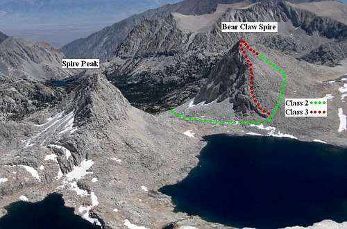 Spire peak and Bear Claw Spire as seen from Feather peak
There is also an option of cutting south half way between Upper Pine lake and Honeymoon lake, go south and up the pine creek drainage. After popping over Pine Creek Pass the hiker will turn and travel west towards Royce lakes. It is not the most direct way but may be used on the approach as an alternative.
Red Tape
Day-hikes do not require a permit"All overnight backpacking trips in the California wilderness areas require a backcountry permit. Currently day trips do not require a wilderness permit, except for the Mount Whitney Trail, Desolation Wilderness, and a select few other areas. In addition, a quota system is in place on many of the popular trails in California including, of course, the Mount Whitney Trail. Check with the respective National Forest or National Park for wilderness permit information and the specific wilderness permit processes as these change from time to time."
Contact
White Mountain Ranger District
798 N. Main Street (Highway 395)
Bishop, CA 93514
Phone: (760) 873-2500
Camping
There are camp sites available on both south west sides of Honeymoon and Upper Pine lakes.My personal choice would be to camp somewhere in the Royce lakes area since the views around there are fantastic. Finding a camp site may be challenging due to presence of large boulders all over the place, but is very doable.
 Summit block as seen from the bottom
Routes to the summit
Southwest ridge is a 3rd class route possible for a person who would like to scrambleSouthwest slopes is class 2 boulder-hopping route that leads to a few possible class 3 moves at the top, and the summit block itself is 4th class. Some people would call it low 5th class. Summit block is exposed with long drops on both sides. Climbing it is easy, holds are there.
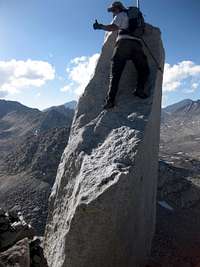 On the summit block
[img:668074:alignright:small:On the summit block]
Also, supposedly there is a 5.6 route on the North side of this peak, which was first climbed by Galen Avery Rowell (August 23, 1940 – August 11, 2002). Galen Rowell was a photographer, and a climber responsible for over a 100 FAs in Sierra, and some other impressive FAs around the world. Some of his FAs include Great Trango Tower in Pakistan, Chalatse of Khumbu region, and Amne Machin in west central China.
External Links
These Maps from Bob Burd's web site may be helpful for navigationhttp://www.snwburd.com/bob/challenge/2010/maps/feather_1.JPG
http://www.snwburd.com/bob/challenge/2010/maps/feather_2.JPG