|
|
Mountain/Rock |
|---|---|
|
|
36.74750°N / 118.3604°W |
|
|
Inyo, Tulare |
|
|
13589 ft / 4142 m |
|
|
Overview
I inherited this page from Dave K in September 2013 and wanted to give my thanks to him for creating this page and giving me the chance to build on it. University Peak is a wonderful dayhike and climb and is easily accessed from Onion Valley, a popular eastside Sierra trailhead. It is set in a very beautiful part of the Sierra Wilderness. University Peak straddles the border between Kings Canyon National Park and the John Muir Wilderness in Inyo National Forest. It is big... 13,589 feet... the biggest peak and a prominent feature near Kearsarge Pass, and beautiful with many graceful and interesting features. University Peak also has great views in many directions. Climbers reaching the summit will see the Great Western Divide, Center Basin, Kearsarge Pinnacles, Mount Clarence King, and Mount Williamson. The first known ascent of University Peak was in 1896 by the early Sierra explorers Joseph LeConte, Helen Gompertz, Estelle Miller, and Belle Miller. University Peak has many different routes with varying difficulties and many different approaches that can be reached in a few hours or as part of a multi-day hike.

Getting There
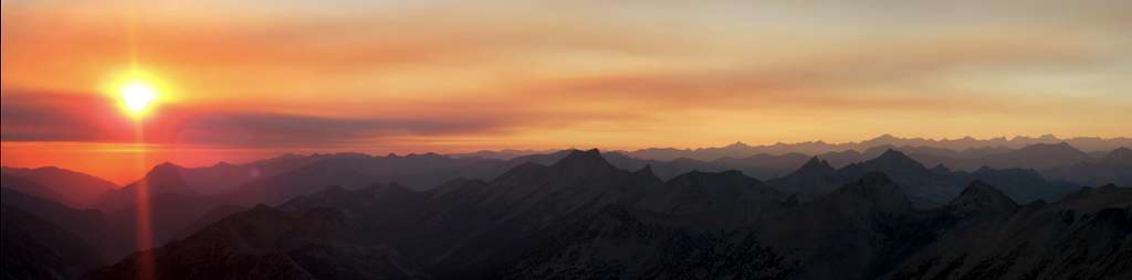
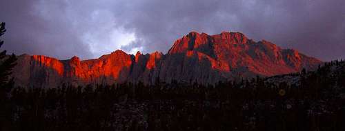
 Sunset on University Peak
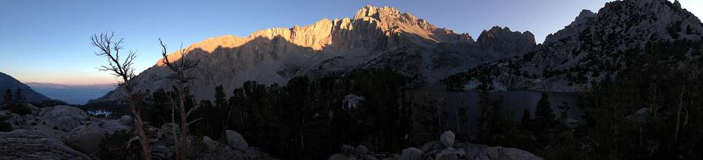
 University from Mount Gould
University Peak is most sensibly approached from Onion Valley in Inyo National Forest. Onion Valley (36.77247° N, 118.34091° W) Turn west off Highway 395 in the center of Independence onto Onion Valley Road (also labeled Market Street). Follow Onion Valley Road 13 paved miles to reach the trailhead at the end of the road.
Approach
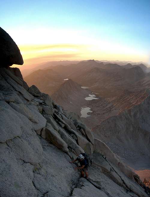 Climbing on the North Face
Though there is only one commonly used trailhead to access University Peak there are two likely approaches. If targeting a route on the north side visitors use the Kearsarge Pass trail (typically leaving the trail in the vicinity of Gilbert Lake). Routes on the south and east aspects are approached via the Robinson Lake trail. The peak has moderate routes on both sides and a nice loop is possible. Trip statistics for Kearsarge Pass Trail to North Face: 3.8 miles one-way, 4400 feet total elevation gain with negligible gain on the return. From Onion Valley Trailhead, hike up the trail towards Kearsarge Pass for 2 miles to Gilbert Lake. Continue south deviating from the main trail onto a side trail, eventually passing Matlock Lake. This trail will become a good use trail that follows the west shore of Matlock Lake. Leave the trail at the western shore of the lake and hike the slopes to the southwest, skirting the southeast edge of Bench Lake. Continue up more slabs, chutes and ledges, aiming towards University Peak and reaching the eastern edge of Lake 3460 directly under the peak. Trip statistics for Robinson Lake Trail to Southeast Ridge: 3.4 miles one-way, 4400 feet total elevation gain with negligible gain on the return. Follow the Robinson Lake Trail (begins inside the campground in Onion Valley) as it climbs rapidly to Robinson Lake. Near the north shore of Robinson Lake a use trail wraps around the east shore of the lake and continues to the talus slopes to the southwest. Follow the inlet stream of Robinson Lake to the source, initially on the eastern side but soon switching over to the west. Talus or snow continues all the way up the bowl east of University Pass. The route becomes steep snow or very loose scree for the final 500 feet or so to the pass. The climb to the pass is completely bypassed if heading to the Northeast Ridge or West Face. A small shortcut to University Peak saving a quarter mile or so for the Southeast Ridge is possible by ascending the right gully at the end of the cirque rather than the left gully (which is the correct route for University Pass). Note that the right gully, however, is just as loose and even steeper than the route to University Pass.
Route Overview
There are many possible route options for climbing University Peak, ranging from straightforward scrambles to more challenging route finding and technical alternatives. Most routes utilize one of the two approaches described above depending on whether they attack from the north or the south. Check out the links to the available route pages themselves for more complete descriptions.
| Route | Rating | Comments |
|---|---|---|
| South Slope | Class 1 | From Center Basin ascend talus and sand to the summit |
| Southeast Ridge | Class 2 | Follows the southern side of the ridge from University Pass |
| Northwest Side | Class 2 | Ascend University Shoulder (southeast of Kearsarge Pinnacles from Kearsarge Lakes on the north or the JMT to the south and traverse to the summit |
| North Face | Class 3 | Ascends the left side of the north face from Bench Lake. |
| East Slope | Class 3 | Begins south of Robinson Lake in the basin north of University Pass |
| Northeast Ridge | Class 4 | Approach the base of the ridge via Robinson Lake |
| Northeast Face | Grade III, 5.7 | Climbs the wall above Slim Lake to the upper part of the Northeast Ridge |
| Direct North Face | Grade III, 5.8 | Passes Lake 3460 and follows scree, class 4, and two 5.8 pitches on an arête en route to the summit |
Red Tape
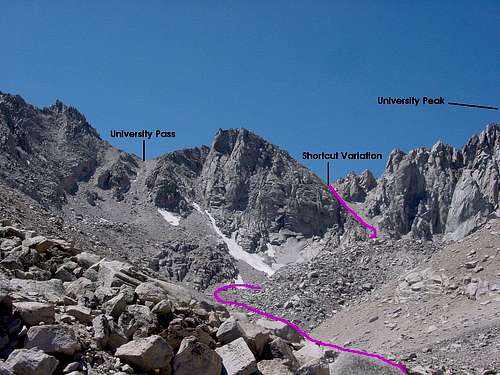 University Pass and the Shortcut Variation to the Southeast Ridge
Entrance Fees: There are no fees if starting from the Onion Valley Trailhead in Inyo National Forest. Wilderness Permits: No permits are required for day trips but overnight trips require one throughout the year. Permits for overnight trips out of Onion Valley in Inyo National Forest can be picked up at the White Mountain Ranger Station in Bishop or the Mt. Whitney Ranger Station in Lone Pine. Quotas are in place May 1 through November 1. Check the Inyo National Forest wilderness permit website for the most current information and reservation availability. There is a high quota for this trail, but reservations are still recommended as this is a popular PCT and JMT resupply point. Food Storage: Bear canisters are required, both in Onion Valley and this area of Kings Canyon National Park. Campfires: Fires are prohibited everywhere in Onion Valley and above 10,000 feet in Kings Canyon National Park. Inyo National Forest Wilderness Permit Office 351 Pacu Lane, Suite 200 Bishop, CA 93514 Wilderness Information Line: (760) 873-2485 Permit Reservation Line: (760) 873-2483
Current Conditions
 Thunderstorm on University Peak from the Kearsarge Pass Trail
Current NOAA / National Weather Service Forecast
When To Climb
The road to the trailhead is not plowed in winter, consequently spring through fall is the most popular time for a visit. In early season snow is present at higher elevations, but those familiar with snow conditions should not have difficulties. Winter ascents have been done and are entirely realistic as the approaches aren't especially overwhelming. Check with the USFS for road conditions if planning a winter or early spring ascent.
 |
 |
 |
 |
 |
 |
Camping
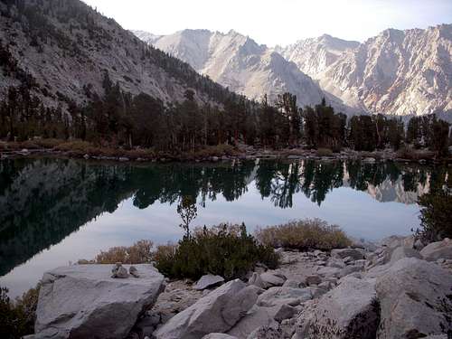 Robinson Lake
Backcountry camping options are abundant at the many lakes on either approach from the trailhead. The distances are not very great, however, so don't expect solitude. Still, seclusion may be more readily available at the offtrail locations such as Bench Lake or Slim Lake. For those visiting University Peak as a dayhike there are many scenic dispersed camping options along Onion Valley Road. There is also an established campground in Onion Valley, as well as Upper Grays Meadow and Lower Grays Meadow on Onion Valley Road. Reservations are available and recommended. The Inyo National Forest Camping page has further details.
Etymology
“Named in honor of the University of California. (J. N. Le Conte.) The name was given in 1890 to the peak north of Kearsarge Pass, but was transferred in 1896 by J. N. Le Conte to the higher peak farther south, while the former peak was named Mount Gould.” – Francis P. Farquhar, Place Names of the High Sierra (1926)