
-
 1901 Hits
-
 0% Score
-
 0 Votes
|
|
Hut/Campground |
|---|---|
|
|
46.43526°N / 13.83808°E |
|
|
Spring, Summer, Fall, Winter |
|
|
6949 ft / 2118 m |
Overview
In Martuljek Group, Julian Alps, there are 5 bivouacs. Bivouac II is one of those which are permanently open. It's the trailhead for the following nearby summit tours:
- On Visoki Rokav, 2647 m. 2 h 30 min, UIAA III.
- On Srednji Rokav, 2589 m, 2 h 15 min, UIAA II.
- On Veliki Oltar, 2621 m, 2 h, UIAA II.
- On Dovški križ, 2542 m, 1 h 30 min, UIAA I.
- On Šplevta, 2272 m. 20 min, T2 walk-up.
It also supports many climbs in the surrounding walls, passages into the neighbouring valleys, longer tours and in spring tour skiing.
Position and Description
|
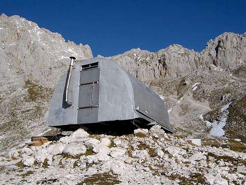
The bivouac stands on the lower edge of Na jezerih plateau, high above the Vrata valley. From it, one has a magnificent view on Triglav (across the valley) and on the nearby mountains. The alpine club of Jesenice started to build the bivouac already in 1936, next year it was finished and much later renewed (last time in 2016). The bivouac is permanently open, its purpose is to support mountain climbs in the group (not longer holidays!). It has 6 beds, a water reservoir, in the bivouac there's an iron oven, wood must be brought by users. Useful phone number: +386 (0)41 733 036. 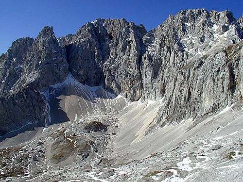
|
Getting There
The usual, shortest ascent is from the Vrata valley, on the Swiss Hiking Scale the non-marked path is graded T3, 3h 15 min.
We best start the ascent on Poldov rovt (meadow), on 941 m. Still free of charge mountain road from Mojstrana, and also free parking place (2021) .
From the meadow we keep left, entering the woods in the NW direction. The path ascends moderately steep, in 2020 on some places on the trail there were fallen trees. In some 45 minutes the path reaches the forested ridge above Rdeči potok (creek), on some 1240 m, where all the hunters paths are branching off.
From that crossroads, we keep left and by a good trail descend slightly into the valley of Rdeči potok. Then we continue by the valley up, in many turns in the N direction. The trail is weak, but not difficult and can be easily followed. When approaching the rocky step, closing the valley, the path goes a bit towards the right, ascending in turns there, till below the distinct rocky head. Then the more demanding (T3) traversing of slopes towards the left follows. The passage is evident, but exposed and we must go carefully. Finally we reach the top of a weak waterfall. It's a very nice place, but in summer water is often missing there and we must search for it under the gravel.

From the waterfall we continue up along the distinct scree ravine. It's better to keep right, in the larch woods and when those end, crossing the scree field to the left. Above us we see an impressive needle, called Mali Materhorn. Below it has a big cave, which is our next goal. A pretty tedious stretch till there, but no dangers at all. On the right we see broad, endlessly high scree fields. From the cave we cross towards them, but then continue scrambling up by their left edge, where the screes are not so soft. Higher, we can ascend even by some steep grassy slopes, choosing the best passages. The bivouac is from below not seen, but we can't miss it, when coming high enough - it's left of scree fields, if looking up.
This is also the fastest descent route, because we slide down more than 500 m of altitude by soft scree fields - all the way till the waterfall.