
-
 11293 Hits
-
 88.19% Score
-
 26 Votes
|
|
Route |
|---|---|
|
|
45.96839°N / 6.86654°E |
|
|
Trad Climbing |
|
|
Summer |
|
|
Half a day |
|
|
D, French 5b |
|
|
5.8 (YDS) |
|
|
Overview
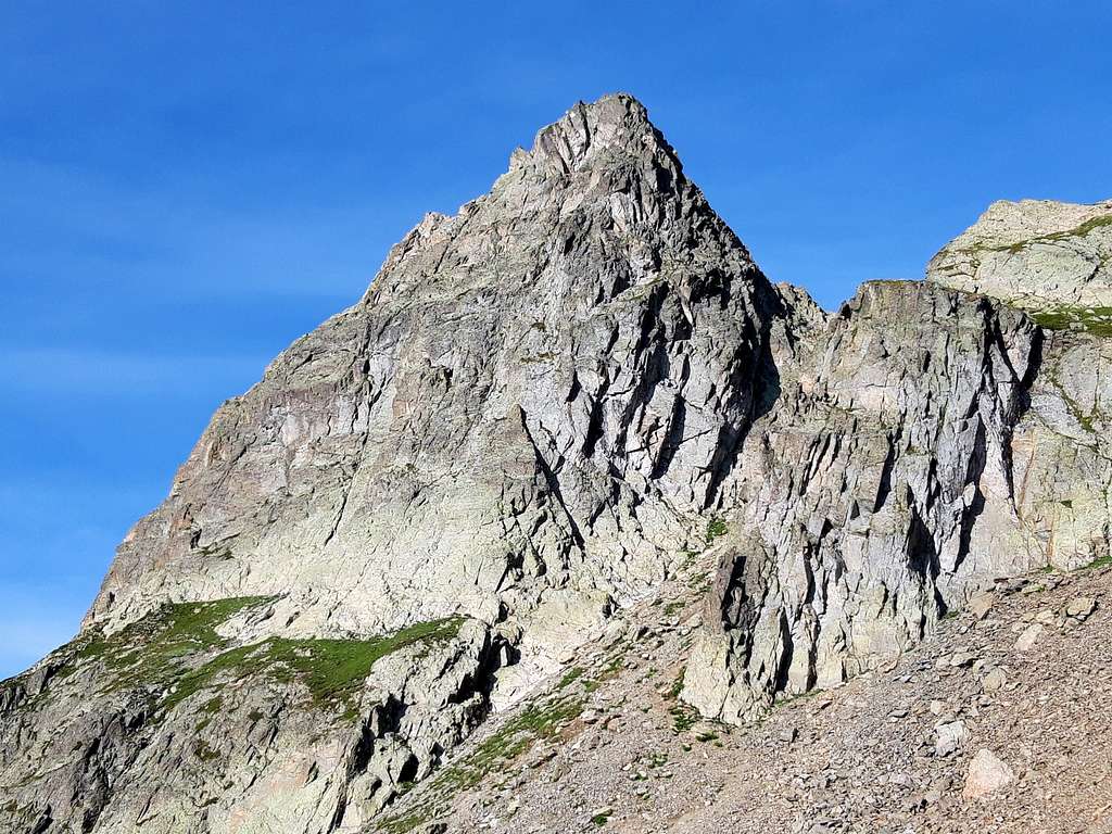
Brunat-Perroux Route (Aiguille de l'Index)
The Aiguilles Rouges may appear small mountains when compared to the giant lying in front of, on the contrary they are fine mountains, in addition to really being a great balcony, giving magnificent views over the massif of Mont Blanc. Actually this fascinating range is rather wide and consists of many interesting summits. Moreover the setting is gorgeous and these peaks offer several interesting climbs.


One of these latter is Aiguille de l'Index, or simply Index, a popular rocky peak resembling an index finger as seen from the village of La Praz, near Chamonix. On its sunny East face a fine and homogeneous route grading 4b-5b is running on very good gneiss, rough and worked. Another important quality of this route is the variety of the climbing styles on slabs, cracks and little walls.
Getting There

The starting point to get the Aiguilles Rouges massif is the town of Chamonix, in the French side of Mont Blanc Group.
Road access to Chamonix Mont Blanc
- Coming from Italy: from Courmayeur you must follow the Mont Blanc Tunnel
- Coming from Wallis (Switzerland): from Martigny (Wallis) follow the road leading to the Switzerland – France border, getting the village of Argentiere and before Chamonix getting Les Praz (42 km. from Martigny).
- Coming from Geneve - Follow the E25 Motorway to St. Gervais les Bains, then the RN 205 to Chamonix and Les Praz
From Chamonix Mont-Blanc head towards NE and reach the village of Les Praz (3 km. from Chamonix). Take the cable-car to “La Flégère”, then the chair-lift of the Index.
More information here: BREVENT-LA FLEGERE
Route Description
Brunat - Perroux Route (Aiguille de l'Index) - French Scale
Summit altitude: m. 2595
Difficulty: D, F5b max
Equipment: pegs and bolts
Climbing length: 250 m
Exposure: E
First ascent: Jean-Christophe Brunat and Godefroy Perroux 1985
Starting point: Index chair-lift upper station (Chamonix Mont Blanc).
Brunat - Perroux route report (French scale)
Approach - From the upper station of the Index chair-lift a short trail heading towards left (SW) leads to the base of Aiguille de l’Index East face (5 minutes). This obvious face situated quite in front of the chair-lift upper station is cut in the middle by a wide grassy ledge. The route starting point is situated near a slab on the right of a corner closed by a roof.

P1 – A long pitch; climb the right face of the corner, then some steep little walls following one another. Belay inside the corner. 5b, 45 m.
P2 – Another long pitch; climb the corner again, 5a, and some little walls on the left, 4b, then go slants to right and climb a spur leading to a stance, lying some meters before the middle grassy ledge. 5a, then 4b, 50 m
P3 – Cross the ledge slants to right and belay at a bolt on a slab, some meters on the right of a little gully.
P4 – Another long pitch; climb directly a slab and some little walls following one another, then go lightly slants to right. 4b, 5b, 50 m
P5 – After some steep steps, 4b, climb a magnificent crack cutting an orange wall, 5b, then a slab. Good stance. 5b, 4b, 40 m
P6 – Traverse 2 meters left to take a slab, 5b, then climb another slab and some little walls. Another good stance. 5b, 4b, 40 m
P7 – Climb a steep wall cut by a beautiful thin and technical crack, 5b, then go slants to right climbing a slab, 4b, leading towards the SE ridge. Belay under a reddish wall. 5b, 4b, 37 m.


P8 – Climb a short chimney-crack, then the summit ridge leading to the top. 3c. 35 m.
Descent: from the summit scramble down a few meters towards NW along the summit ridge to find a stance with a double abseils’anchors. Two abseils (30 m. and 50 m.) are leading to the Eastern gully of the Index Col. From here follow a steep trail towards East, easy without snow, leading to the starting point.


Essential Gear
Rope 2x50 m, helmet, nuts 4-9, friends 1,2,3, 10 quickdraws, slings.
Red tape
No particulary restrictions in climbing and hiking.
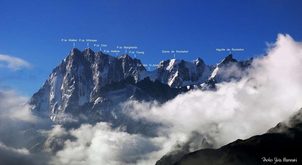
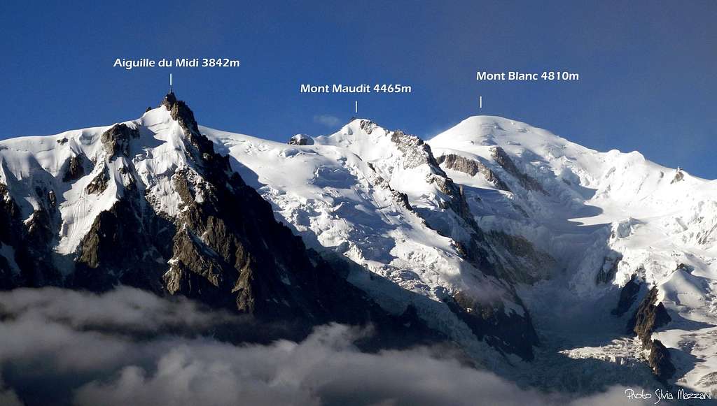
Mont Blanc massif views from Index


When to climb
Best season goes from middle June to the end of September.
Where to stay

Chamonix is a primary touristic destination. Hotels, huts, gites, renting rooms. Numberless campings are situated in the Northern and Southern ends of the town.
Main campsites:
- Camping la Mer de Glace - Les Praz (3 km. North to Chamonix) +33(0)450534403
- Camping les Deux Glaciers - Les Bossons (3 km. South to Chamonix) +33(0)450531584
- Camping les Arolles - close to the centre of Chamonix - +33(0)450531430
- Camping les Cimes - Les Bossons (3 km. South to Chamonix) +33(0)450535893
- Camping Glacier d'Argentière - Argentière (8 km. North to Chamonix) +33(0)450541736
- Camping les Marmottes - +33(0)450536124
Meteo
Chamonix Meteo
Meteo France-Rhone Alpes
Other informations
- Office du Tourisme de Chamonix Phone +33 0450 530024 Chamonix Mont-Blanc
- Office de la Haute Montagne de Chamonix Phone +33 0450 532208 Office de la Haute Montagne
- Cable-car informations Phone +33 0450 532275 CompagnieduMontBlanc
Guidebooks and maps


- "Monte Bianco classico & plaisir" by Marco Romelli, Edizioni Idea Montagna
- "Mont Blanc & the Aiguilles Rouges" - selected climbs - in English
- “Les Aiguilles Rouges – Face au Mont Blanc” by Michel Piola –
- “Alpes Francaises du Nord” by Hervè Galley - Editions Olizane