
|
|
Canyon |
|---|---|
|
|
42.77947°N / 19.29061°E |
|
|
Canyoneering |
|
|
Summer |
|
|
Mrtvica River - Treasury of Nature

 Wooden Bridge & Mrtvica River
Montenegro is the home of many incredible river's canyons. Mrtvica Canyon is less known then wide known Tara Canyon, which is deepest, longest and the most popular canyon of Montenegro. But, the beauty of Mrtvica Canyon is really awesome! Many people who visited amazing beauty of Mrtvica Canyon told that Mrtvica canyon was made very deep and great impression on them. Maybe the best prove of that is THIS amazing postcard of Mrtvica Canyon, made from helicopter by famous Serbian photographer Branislav Strugar.
The Mrtvica River runs at the foot of the northern side of Mt Maganik 2139 m) and empties into the Moraca River. Mrtvica is placed in SE part of beautifully Moracke Planine.
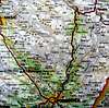
The whole Mrtvica Canyon is 8 km long, 35km far from Kolasin, in the direction of Podgorica. The banks of the river Mrtvica, the right tributary of the Moraca river, are steep, high and abundant with vegetation. At certain places, they are more then 1100 m high.
The narrow sandy path has carved its way through the canyon. Specially attractive are springs called "Bijeli nerini" – White "nerins". On the Mrtvica river near Zeleni Vir (Green Wortex), there is an old stone bridge built by prince Knjaz Danilo II Petrovic as a memorial to his mother. The river’s cleanse waters abound with trout, huchen and other rare species.
 The Gate of Wishes
Impressive beauty of Mrtvica Canyon offer amazing adventure par excellance and for sure unforgetable deep impressions to anyone who visit it. So, welcome to discover astonishing beauty of Mrtvica Canyon!
Route Description


Medjurijecje (211 m) - Mrtvo Duboko bridge (240 m)- Mrtvicke Grede (340 m) - Velje Duboko village (823 m)(T3): 4.30h
Tour Totals:
Heigh difference: 612 m
Lenght: 12.5 km
Duration: 4.30h
Trail: Unmarked
WAYPOINT:
1. Medjurijecje 42°43'06,5'' N; 19°22'31,6'' E; 211 m
2. Mrtvo Duboko bridge 42°43'44,6'' N; 19°20'44,8'' E; 240 m
3. Mrtvicke Grede 42°44'21,8'' N; 19°19'41,4'' E; 340 m
4. Velje Duboko village 42°46'46,1'' N; 19°17'26,2'' E; 823 m
MEDJURIJECJE - MRTVICA CANYON - VELJE DUBOKO:
From Podgorica to Medjurijecje is about 35 km. Bus usually stops in front of Bjelasica Hotel. From that point, you walk about 300 m back on the road, to an overpass, with few houses around it, then turn right on an asphalt road (this road is on the left, when coming from Podgorica, just so that there is no confusion). Soon after that you cross the steel bridge over Moraca. 50 m further from the bridge is a little path going left. It is very important that you don't miss this path. Left of the path Mrtvica river joins Moraca river. Across Mrtvica there iz a village Stanci. 500 m further is a beautiful Danilov Most bridge (legacy of Knjaz Danilo II Petrovic), next to it is a stone plate with an inscription. On that small crossroads, you shouldn't go straight and reach a small water mill, but, without crossing the bridge, go on a narrow path that goes upward and to the right. The first 150 m you go through the bushes, and after crossing a stream, turn right. After another 500 m you'll find a stone-paved road that goes on for about 3 km. It ends in the proximity of few houses, and from there on it's a path again. From that point on your left you can see the wooden bridge over Mrtvica, across which is a way to Mrtvo Duboko village. From there on the canyon narrows, and you can't miss the way to Velje Duboko: mostly on the right (looking up the river). In that part of the way leads you under the mountain peaks: Razbijena Jela (1687 m) on the left side, across Mrtvica; Venac (1345 m) and Lijesnje (1187 m) on the right. On that vary part, between Venac and Lijesnja, there is an impressive track, cut into the cliffs (made by former Yugoslav army) that goes 50 m above Mrtvica River. The part of it, of course, was man-made (no use explaining it, though, you should see it for yourselves). In the final part, the canyon widens again, there is much more vegetation. Then trail crosses over to the right bank (on the Mt Maganik side). At the high water of Mrtvica river at this point the crosspassing of the river may be dangerous. By the end of May the riverbad is mostly dry. The greatest height of the canyon is 1100 m in the area of the Razbijena Glava katun (lodge). Exiting the canyon, cross the bridge at the beginning of the Velje Duboko valley. A travel road leads west, then later northwest towards the Kapetanovo Jezero (Captain's Lake) in Moracke Planine (Moraca Mountains).
Getting There
 Beach on Mrtvica River
 Wooden bridge to Mrtvo Duboko village
 Prince Danilo's Bridge
By plane:
The closest airport is the one in Podgorica (70km away).
 Mrtvica Canyon
Information about flights and tickets on JAT Airways web page.
By train:
Beograd - Bar (Bar - Beograd) railway passes through Mojkovac and Kolasin. Then by car or taxi from Kolasin to Medjurijecje. In winter, there is a special ski-train for Kolasin from Bar and Podgorica. When you get off it, a ski bus will take you straight to the ski resort.
By Bus:
From Beograd (Belgrade):
Beograd (Belgrade) - Cacak - Uzice - Zlatibor - Nova Varos - Prijepolje - Bijelo Polje - Mojkovac - Kolasin
Then by car or taxi from Kolasin to Medjurijecje.
From Podgorica:
Podgorica - Kolasin
Then by car or taxi from Kolasin to to Medjurijecje.
For the bus tickets and informations about but lines see Belgrade Bus Station page.
By car:
From Beograd (Belgrade):
Beograd (Belgrade) - Cacak - Uzice - Zlatibor - Nova Varos - Prijepolje - Bijelo Polje - Mojkovac - Kolasin - Medjurijecje
From Podgorica:
Podgorica - Kolasin - Medjurijecje: 35 km
Mojkovac - Kolasin road goes from the E side of the Moraca Mountains
Savnik - Kolasin goes on the SW side of the Moraca Mountains
You should drive along the central Montenegrin highway, which connects the seaside to the towns: Cetinje - Podgorica - Kolasin - Mojkovac - Bijelo Polje; and goes on to Serbia (Belgrade city). This road is passable during most part of the year. It is closed only in case of abundant snowing or great rockslides. The landscape along the highway is particularly picturesque in the segment of the Moraca River Canyon between Podgorica and Kolasin. This part of the canyon is called "Platije". The highway is built along the edge of the narrow canyon. Thus, you can enjoy in observing the beautiful contrast between steep, dark cliffs and light, green river, while round, white peaks of Bjelasica glow in the distance. At moments, this beauty becomes scary!
From Podgorica you can also take the village road for Kolasin. It goes across Lijeva Rijeka, Verusa and Matesevo. One part of it goes along the Tara River, which in this area is like a small, gentle and playful spring. The road is narrow, but in good condition. From the north, you will reach Kolašin if you take the highway that passes through Mojkovac. If you are coming from the east you should go across Andrijevica through Matesevo to arrive to Kolasin. You will be surprised by the difference in the landscape of the northern and the southern access to Kolasin. Unlike the south, the vegetation in the north is more lush, green and soft.
If you travel by car you will not depend on local bus routes. Buses are quite regular along the main roads, but if going by bus you will not enjoy as much in beautiful rural landscapes. In particular, the recommendation is that you do not take a bus in winter snowy days. It is better to rely on the train then, because roads might be impassable.
Camping
 The track in the rocks
The best time for your adventure in Mrtvica Canyon is April - October period.
In the Moracke Planine (Moraca Mountains) area, specially in the area of Mt Maganik don't exist mountain huts, so you can freely use your private bivouacs and sleeping bags and put them belowe the peaks of the Moraca Mountains, outside of Mrtvica Canyon. Also, you can use empty shepherd's lodges for stay inside.
Medjurijecje village is the best place for stay or camping before your visit of Mrtvica Canyon.

Meteo
The best meteo for Mrtvica Canyon is YUBC NET page. 5 days meteo, 4 times daily:Look meteo for the Kolasin town.
Red Tape
No fees or extra fees for entering the Mrtvica Canyon, in the area of Moracke Planine (Moraca Mountains).No permits needed either.
Usual rules of behaviour for NP's do apply.
Ivan - Apr 21, 2016 5:57 pm - Hasn't voted
video linkhttps://youtu.be/fY-hFDz48c4
Milica O. - Jun 17, 2017 5:18 pm - Hasn't voted
Hostel in Medjurijecjehttps://www.facebook.com/Hostel-u-Medjurijecju-Kolasin-Crna-Gora-325607097871311/