
|
|
Area/Range |
|---|---|
|
|
42.73000°N / 19.29128°E |
|
|
7018 ft / 2139 m |
|
|
Wildest mountain range of Montenegro
 Međeđi Vrh & Babin Zub from Prekobrđe (Donja Morača)
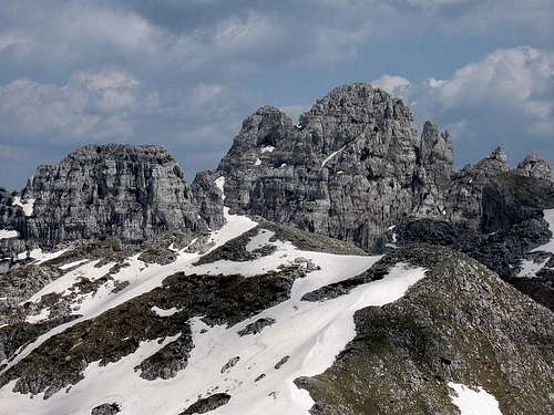 Impressive rocky massif of Maganik
MAGANIK is 20 km long and 10 km wide mountain range placed in the middle part of Montenegro, precissely between the rivers of Zeta, Moraca and Mrtvica. The massif of Maganik stretches in east-west/northwest direction. That beautiful and impressive range with its unique outlook is separated from Moracke Planine on the north and from Prekornica mountain on the south. Maganik is known as a little beat unapproachable mountain range. Its rocks are on some places very dangerous and sharp like a knife. Maganik is surrounded by many katuns (lodges) where people living on the mountain only during summer. Known katuns are Rekocica, Maganik, Poljana, Vragodo, Ogradjenik, Zabrdje, Razbijena Jela, Magline, Stanjevica Rupa, Besovica Katun and others.
Maganik is an aloof group of impressive limestone formations. The geological composition of Maganik is made of cretaceous bank limestone. The base of this mountain range from the Niksic side and the Moraca River valley is made up of Tiassic limestone. The canyon slopes of the river Mrtvica are formed by Triassic, Jurassic and cretaceous limestone, which created a rich vertical jaggedness to the Maganik mass that appears frightening to the mountaineer. Its relief is enriched with deep karst hollows, valleys and funnel-shaped depressions.
The highest peaks of Maganik range are:
- Medjedji Vrh (2139 m)
- Petrov Vrh (2124 m)
- Babin Zub (2119 m)
- Zuta Greda (2104 m)
- Rogodjed (2037 m)
- Kokotov Vrh (2001 m)
- Cakmakov Vrh (1974 m)
Maganik offer many outstanding summit panoramas as are the views to Prokletije, Komovi, Moracke Planine and Kucke Planine.
Routes Info
 Maganik scenery
Medjurijecje (211 m) - Mrtvo Duboko village (360 m) - Granica village (1042 m) - Poljana katun (1594 m) - Medjedji Vrh peak (2139 m): 6.30h
Height difference: 1778 m
Lenght: 10,5 km
Duration: 6.30h
Unmarked trail
From Podgorica, there are 33 km on the Adriatic highway to the Pjenavac bridge in the direction of Kolasin. The start of this trail is at that bridge. Turn left and its 5 km of gravel road to the Mrtvo Duboko School. From there follow the steep path through the beech trees towards the southwest village of Granica and the lane that leads to the Poljana katun. This katun is located under the Medjedji Vrh peak. One can also go by wagon trail to the village of Granica, turning onto a road 1 km before the Pjenavac bridge on the Adriatic highway and then go to the village of Trmanja. After a few kilometers, a leg separates and goes to Granica. One can also take shortcuts on foot.
The ascent from the Poljana katun to the top is north towards the Razvrsje Plateu and then goes through a jagged limestone ridge on the eastern slope of the Medjedji Vrh peak, through meadows and rocky ground. For the return and for its beauty, it is recommended to descend northwest through the Strbina Pass. Then go north toward the katuns of Zabrdje (1722 m) and Ogradjenik, to Velje Duboko. From Velje Duboko, along the Mrtvica Canyon, descend to Medjurijecje. This descent goes from Medjedji peak, through the Zabrdje katun farther on to the Mrtvica Canyon. This tour can also be made from Velje Duboko on a gravel road 12 km through Lijesnja and Cerovice down to Medjurijecje. It is also recommended to plan two days, with and overnight stay in the Zabrdje katun.
 Maganik & Mrtvicke Grede above Mrtvica Canyon
Niksic - Laz - Kutsko Brdo - Stitovo - Rekocica 1512m - Maganik katun (1621 m) - Medjedji Vrh peak (2139 m): 3h
Height difference: 626 m
Lenght: 6,5 km
Duration: 3h
Unmarked trail
For one who chooses this approach to Mt Maganik's Medjedji Vrh peak by all-terrain vehicle from Niksic, take the Niksic-Zupa asphalt road near the village of Laz, turning left onto another asphalt road and then take the gravel road through Oblatno to Kutsko Brdo (bauxite mines). Cross the Sititovo plain to the Rekocica katun (1512 m). The beginning of this trail is at the katun of Rekocica, ascending along a steep goat trail northeastwardly to the old katun of Maganik. The path then goes through a vale to the Strbina pass between the Kokotov (2001 m) and Medjedji Vrh peaks. Right and southeast of the pass via a rocky crest is the ascent to Medjedji Vrh summit (2139 m).
Getting There
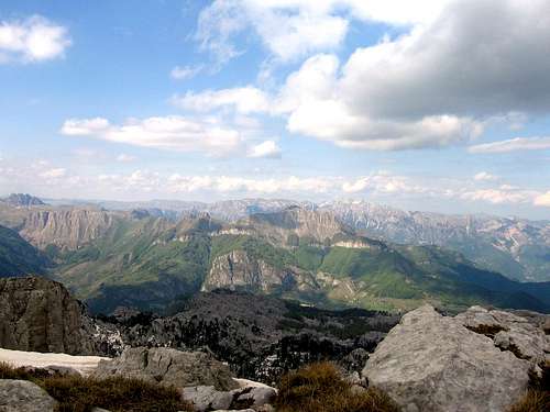 Maganik summit view to Moracke Planine and Sinjajevina
From Podgorica
Podgorica - Medjurijecje - Mrtvo Duboko village - Granica Village - Poljana Katun
From Niksic
Niksic - Morakovo - Rekocica - Maganicko Polje
Camping
 Maganik from Moracke Planine (Stozac summit)
You can camping on many places below and around the Maganik mountain range. There are no mountain huts. You can stay in wooden lodges called Katuni or in your tent.
Red Tape
No extra fees.Map
 Map of Maganik area