
|
|
Area/Range |
|---|---|
|
|
42.86300°N / 19.38400°E |
|
|
7303 ft / 2226 m |
|
|
Overview
  |
 |
 |
 |
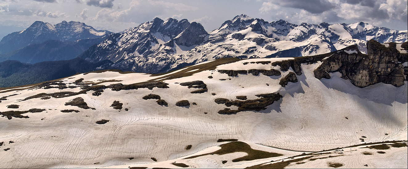
 Beautiful panorama of Moracke Planine range
 Moracke Planine
Moračke Planine (Morača Mountains) belongs to the group of most beautiful mountains of Montenegro. Morača Mountain range is located in the central part of Montenegro. They extend east to northwest beginning at the Tara River canyon near Kolašin town, and then along the series of beautiful peaks, of mountains: Vučje, Umovi, Sto, Crni Vrh, Tali & Stožac.
The Gradista Ridge closes this series of peaks from the west while the Vratlo Pass separates it from the Jablanov Vrh (2203 m), second highest peak of Mt Sinjajevina range. This range is limestone in composition. In geographical literature some geographers ascribe the Moraca Mountains to the Sinjajevina.
 Moraca Canyon
The Moračke Planine range is surrounded from the west by the Lola Ridge and plateau; from the southwest by the pasture plateau of Mt Lukavica with two impressive Zurim's (2035 m), Mali and Veliki (little and big), and by the source of the wide Moraca River Canyon on the north and northeast. The Moraca Mountains hold the distinctive summits of: Kapa Moracka - Lastva (2226 m), Zagradac (2217 m) and Stozac (2141 m) as well as the Maganik with it's Medjedji Vrh (2139 m) and a series of other peaks at heights is over 2000 m.
The Moracke Planine are topographically and climactically attractive. While the southern slopes are under the influence of the Mediterranean climate, with it's typical foliage, their northern slopes remain snow covered for a long time and where the frigid zone flora flourish, which survived through the Ice Age melting of this part of the Balkans.
The glacial lakes of Kapetanovo Jezero (Captain's Lake) and Brnjicko (Manito) Jezero formed on the surface of the Moracke Planine.
 Kapetanovo Jezero (Captain's Lake, 1672 m)
 Stozac (2141 m) above Manito Jezero lake
Moracke Planine are rich with many beautifully peaks.
 Kapa Moracka 2219 m
Here is the list of the highest peaks:
- Kapa Moracka (Lastva) 2226 m
- Zagradac (2217 m)
- Gornji Sto (2167 m)
- Stozac (2141m)
- Maganik (2139 m)
- Stit (2132 m)
- Veliki Zebalac (2129 m)
- Lijevno (2081 m)
- Vojnovac (2072 m)
- Tali (Kula) (2063 m)
- Lukanje Celo (2049 m)
- Veliki Zurim (2036 m)
- Budiguz (1966 m)
- Mali Zurim (1836 m)
- Donje Vucje (1506 m)
 View to DURMITOR (Bobotov Kuk - 2523 m)
 View to Komovi range
VIEWPOINT: Kapa Moracka (Lastva 2226 m); 42°50'22.1'' N ; 19°15'15.2'' E
01. Sinjajevina (Veliki Pecarac) 2042 m; Distance: 18 km
02. Sinjajevina (Babji Zub) 2277 m; Distance: 11 km
03. Bjelasica (Crna Glava) 2139 m; Distance: 37 km
04. Komovi (Kucki Kom) 2487 m; Distance: 38 km
05. Kucka Krajina Mountains (Surdup) 2184 m; Distance: 37 km
06. Lovcen (Stirovnik) 1748 m; Distance: 62 km
07. Njegos 1721 m; Distance: 42 km
08. Golija 1942 m; Distance: 43 km
09. Bioc (Veliki Vitao) 2397 m; Distance: 58 km
10. Durmitor (Bobotov Kuk) 2523 m; Distance: 37 km
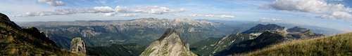 Kapa Moracka (2226 m) summit view to SINJAJEVINA (2277 m), KOMOVI (2487 m) and PROKLETIJE (2694 m)
LOCATION:
Moracke Planine (Moraca Mountains) are placed in the heart of Montenegro, in it's central part, on the W from Kolasin town and SE from Savnik town. The Moraca Mountains are surrounded by many beautiful mountains and national parks. This beautiful mountain is situated on the SE from Durmitor National Park (2523 m), Maglic (2388 m), Bioc (2397 m), Volujak (2336 m), Ljubisnja (2238 m), on the NW from Prokletije (2694 m), Komovi (2487 m), Hajla (2403 m), Visitor (2211 m), Bjelasica (2139 m), Kucka Krajina Mountains (2184 m) and Mokra Planina (2003 m), on the N from Moraca Mountains (2226 m), Maganik (2139 m), on the E from Golija (1942 m) and Vojnik (1997 m), on the SW from Kopaonik (2017 m), Golija (1833 m), Zlatar (1626 m), Javor (1519 m), Mt Zlatibor (1496 m) mountains in Serbia, on the W from Pester (1617 m) mountain in Serbia.
Moracke Planine (Moraca Mountains, 2226 m) offers an extraordinary mountain adventures, many hiking and climbing routes, enjoyment in the beauty of the glacial lakes. So, it's the right time for you to discover these beautiful mountains and enjoy in their's breathtaking beautiful panoramas.
 |  |  |  |  |
Routes Overview
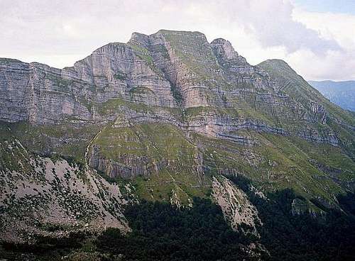 Impressive wall of Tali (2063 m) peak
KAPA MORACKA (Lastva, 2226 m)
Coordinates: 42°50'22.1'' N ; 19°15'15.2'' E
Route: Kapetanovo Jezero lake (1672 m) - Lastva Peak (2226 m)(T2) 2.30h - Zagradac summit (2217 m)(T2+T3) 1.30h: 4h
Height difference: 555 m
Lenght: 7.5 km
Duration: 4h
Trail: Unmarked
Registration book with stamp on Zagradac (2217 m) summit
STOZAC (Stozac, 2140 m)
Coordinates: 42°48'33.2'' N ; 19°15'35.2'' E
Route: Kapetanovo Lake lake (1672 m) - Manito Jezero lake (1764 m)(T2) 1h - Stozac summit (2140 m)(T2) 1.30h: 2.30h
Height difference: 469 m
Lenght: 5.5 km
Duration: 2.30h
Trail: Unmarked
Registration book with stamp on Stozac (2140 m) summit
Mt LOLA (Veliki Zebalac, 2129 m)
Coordinates: 42°52'13.2'' N ; 19°13'53.1'' E
Route: Strug (1475 m) - Popov Do (1750 m)(T1) 1h - Borova Brda summit (2006 m)(T2) 45 min - Mali Zebalac summit (2073 m)(T2) 45 min - Veliki Zebalac summit (2129 m)(T2+T3) 1h: 3.30h
Height difference: 654 m
Lenght: 12.5 km
Duration: 3.30h
Trail: Unmarked
Registration book with stamp on Veliki Zebalac (2129 m)
Mt TALI (Ruda Glavica, 2020 m)
Coordinates: 42°48'48.0'' N ; 19°20'12.0'' E
Route: Gazela bridge & Osreci village (375 m) - Ropusnica katun (1472 m) - Korita (Kotla) katun (1485 m) - Ruda Glavica summit (2020 m)(T3): 3h
Height difference: 548 m
Lenght: 3 km
Duration: 3h
Trail: Unmarked
Registration book with stamp on Ruda Glavica (2020 m) summit
ZURIM Mt's (Veliki Zurim, 2036 m)
Coordinates: 42°50'03.0'' N ; 19°11'19.2'' E
Route: Bare Bojovica (1540 m) - Veliki Zurim summit (2036 m)(T2) 1.30h - Mali Zurim summit (1962 m)(T2+T3) 1.30h - Ilin Vrh summit (2051 m)(T2) 1h: 4h
Height difference: 511 m
Lenght: 7.5 km
Duration: 4h
Trail: Unmarked
UMOVI Mt's (Umovi, 1945 m)
Coordinates: 42°50'45.8'' N ; 18°26'09.1'' E
Route: Crkvine (1045 m) - Bistrica spring (1258 m)(T2) 1h - Barski Katun (1462 m)(T2) 30 min - Miocki Katun (1542 m)(T2) 30 min - Umovi summit (1945 m)(T3) 30 min: 2.30h
Height difference: 900 m
Lenght: 8.5 km
Duration: 2.30h - 3h
Trail: Unmarked
Mt MAGANIK (Medjedji Vrh, 2139 m)
Coordinates: 42°43'48.0'' N ; 19°17'28.6'' E
Route: Medjurijecje (211 m) - Mrtvo Duboko (360 m)(T2) 1.30h - Granica (1042 m)(T2) 2h - Poljana (1594 m)(T2) 1.30h - Medjedji Vrh summit (2139 m)(T3) 1h: 4 h
Height difference: 1778 m
Lenght: 10.5 km
Duration: 6h
Trail: Unmarked
Registration book with stamp on Medjedji Vrh (2139 m) summit
 |  |  |
Getting There
 Kapa Moracka (Lastva, 2226 m)
By plane:
The closest airport is the one in Podgorica (70km away).
If you are planning to come via Serbia, you can use the Belgrade (Beograd) Airport in Beograd (Belgrade) city, capital of Serbia and Montenegro.
Information about flights and tickets on JAT Airways web page.
By train:
Beograd - Bar (Bar - Beograd) railway passes through Mojkovac and Kolasin. Then by car or taxi from Kolasin to Podgorica - Nikšić - Nikšićka Župa - Morakovo - Zagrad village - Oblatno village - Bare Bojovića
By Bus:
From Beograd (Belgrade):
Beograd (Belgrade) - Cacak - Uzice - Zlatibor - Nova Varos - Prijepolje - Bijelo Polje - Mojkovac - Kolasin
Then by car or taxi from Kolasin to Podgorica - Nikšić - Nikšićka Župa - Morakovo - Zagrad village - Oblatno village - Bare Bojovića
From Podgorica:
Podgorica - Kolasin
Then by car or taxi from Kolasin to Podgorica - Nikšić - Nikšićka Župa - Morakovo - Zagrad village - Oblatno village - Bare Bojovića
For the bus tickets and informations about but lines see Belgrade Bus Station page.
 Beautiful scenery of Kapetanovo Jezero lake
By car:
From Beograd (Belgrade):
Beograd (Belgrade) - Cacak - Uzice - Zlatibor - Nova Varos - Prijepolje - Bijelo Polje - Mojkovac - Kolasin - Podgorica - Nikšić - Nikšićka Župa - Morakovo - Zagrad village - Oblatno village - Bare Bojovića
From Podgorica:
Podgorica - Kolasin - Gornje Lipovo - Klisura (1189 m)
- Mojkovac - Kolasin road goes from the E side of the Moraca Mountains
- Mojkovac - Djurdjevica Tara road goes from the NE side of the Moraca Mountains
- Djurdjevica Tara - Savnik road start from the NW side of the Moraca Mountains (lower quality of the road)
- Savnik - Kolasin goes on the SW side of the Moraca Mountains
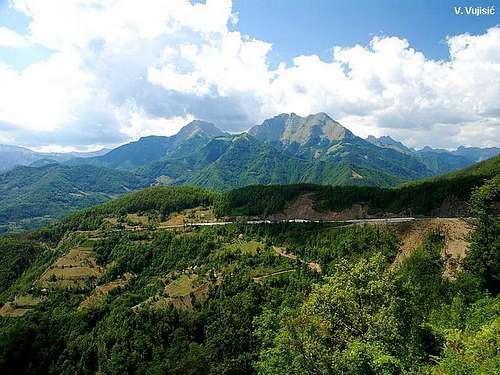
You should drive along the central Montenegrin highway, which connects the seaside to the towns: Cetinje - Podgorica - Kolasin - Mojkovac - Bijelo Polje; and goes on to Serbia (Belgrade city). This road is passable during most part of the year. It is closed only in case of abundant snowing or great rockslides. The landscape along the highway is particularly picturesque in the segment of the Moraca River Canyon between Podgorica and Kolasin. This part of the canyon is called “Platije”. The highway is built along the edge of the narrow canyon. Thus, you can enjoy in observing the beautiful contrast between steep, dark cliffs and light, green river, while round, white peaks of Bjelasica glow in the distance. At moments, this beauty becomes scary!
From Podgorica you can also take the village road for Kolasin. It goes across Lijeva Rijeka, Verusa and Matesevo. One part of it goes along the Tara River, which in this area is like a small, gentle and playful spring. The road is narrow, but in good condition. From the north, you will reach Kolašin if you take the highway that passes through Mojkovac. If you are coming from the east you should go across Andrijevica through Matesevo to arrive to Kolasin. You will be surprised by the difference in the landscape of the northern and the southern access to Kolasin. Unlike the south, the vegetation in the north is more lush, green and soft.
If you travel by car you will not depend on local bus routes. Buses are quite regular along the main roads, but if going by bus you will not enjoy as much in beautiful rural landscapes. In particular, the recommendation is that you do not take a bus in winter snowy days. It is better to rely on the train then, because roads might be impassable.
When To Climb
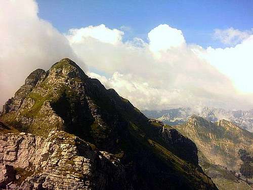 Moracke Planine range from Tali (2063 m)
Moracke Planine (Moraca Mountains, 2226 m) offer nice hiking and climbing adventures. The Moraca Mountains you can climb whole year. If the snow is hard and frozen, bring with you the crampons and ice axe.
The best period for the Moraca Mountains peaks climbing is mid June - mid October.
 |
Camping
In the Moracke Planine (Moraca Mountains) area don't exist mountain huts, so you can freely use your private bivouacs and sleeping bags and put them belowe the peaks of the Moraca Mountains. Also, you can use empty shepherd's lodges for stay inside. |
Mountain Conditions
The best meteo for Moracke Planine (Moraca Mountains) - is YUBC NET page. 5 days meteo, 4 times daily:Look meteo for the Kolasin town.
Red Tape
No fees or extra fees for entering the Moracke Planine (Moraca Mountains).No permits needed either.
Usual rules of behaviour for NP's do apply.