
|
|
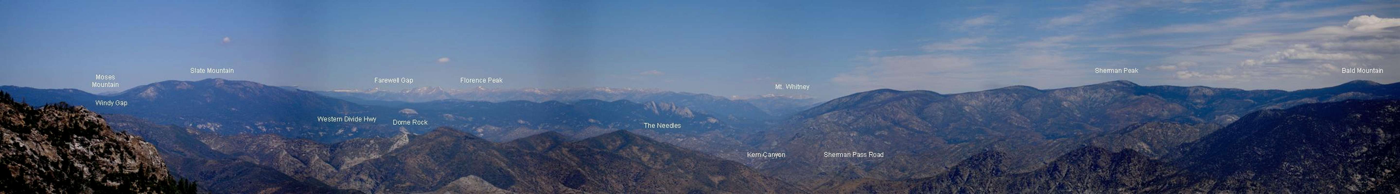
Canyon |
|---|---|
|
|
36.13100°N / 118.438°W |
|
|
Hiking, Mountaineering, Trad Climbing, Sport Climbing, Toprope, Bouldering, Ice Climbing, Aid Climbing, Big Wall, Mixed, Scrambling, Via Ferrata, Canyoneering, Skiing |
|
|
Spring, Summer, Fall, Winter |
|
|
Overview
The Kern River is the only major Sierra river to flow north to south. It runs nearly a straight line down the 87-mile long Kern Canyon Fault from the highest Sierra peaks including Mt. Whitney and south in two main forks that have carved dramatic canyons along their paths. In its northern portion, the North Fork is a beautiful U-shaped canyon that was carved by glaciers. At about the boundary between Sequoia National Park and Sequoia National Forest it takes on a river V-shape. Shortly thereafter it is joined by the Little Kern River whose entire watershed is within the Golden Trout Wilderness. Once it reaches the area near Lake Isabella, it joins with the South Fork then changes direction and makes a right-hand turn and then flows on to Bakersfield. In historic times it filled up Buena Vista Lake but nowadays most of the water is used for domestic and agricultural purposes.The South Fork originates on the Kern Plateau and descends through deep gorges with large granite outcroppings and domes interspersed with open meadows. It is habitat for the golden trout, the state fish of California, and the only fish native to the High Sierra.
The Kern River splits the Sierra Nevada into two distinct sub-ranges: to the west is the Great Western Divide and to the east is the Sierra Crest.
Both Forks of the Kern River are designated as Wild and Scenic Rivers. The North Fork from the Tulare-Kern County line to its headwaters in Sequoia National Park and the South Fork from its headwaters in the Inyo National Forest to the southern boundary of the Domeland Wilderness in the Sequoia National Forest were designated as Wild and Scenic on November 24, 1987.
The area around Lake Isabella is unique as it's where 5 bioregions converge. Here the San Joaquin Valley meets the Mojave and Great Basin Deserts and the Sierra Nevada Mountains meet the Tehachapi Mountains. An amazingly wide variety of plant and animal life can be found here!
The Kern River is world famous for its whitewater rafting and kayaking as well as its fishing opportunities. But there are endless recreation opportunities along the Kern River and at Lake Isabella including: camping, hiking, climbing, horse-back riding, windsurfing, kite-surfing, para-sailing, water skiing, swimming, fishing, hunting, bird-watching, mountain biking, OHV riding, snow sports, etc. Pretty much if you can think of it, you can do it somewhere along the Kern River.
  |
Getting There
The North Fork Kern River originates near Mt. Whitney in Sequoia National Park. The South Fork Kern River originates near Cirque Peak in the Inyo National Forest. The upper portions of both are in Wilderness Areas that are accessible only on foot or horseback. The first time the South Fork reaches a road is near Kennedy Meadows and this is the Sherman Pass Road. It then flows through the Domeland Wilderness and exits near Hwy 178. The first time the North Fork reaches a road is M-99 north of Kernville and just east of Johnsondale. Highway 178 parallels the river in its lowest portion as it rushes down from Lake Isabella to Bakersfield.Trailheads to the wilderness areas along the Kern River coincide with those going into the Golden Trout Wilderness and Domeland Wilderness.
Red Tape
Wilderness Permits are needed to hike to the upper portions of the Kern River. If your trip originates in Sequoia National Forest, click here. If your trip originates in Sequoia National Park, click here. If your trip originates in the Inyo National Forest, click here.There are food storage requirements in Sequoia and Kings Canyon National Parks and the Inyo National Forest for keeping your food safe from bears. Click here for more info.
Click here to find out info on fishing regulations.
Permits for whitewater boating on the Upper and Lower Kern River runs are required year-round. Permits must be obtained in person and a picture I.D. is required. Permits for whitewater boating on the Forks of the Kern River run are required May 15 to September 15 each year. Permits may be obtained at the Kernville or Lake Isabella Ranger Stations, contact info is below. Click here for more info.
Ranger Stations
Kernville Ranger Station105 Whitney Road
Mailing Address: PO Box 9, Kernville, CA 93238
Office Hours: 8 a.m. – 4:30 p.m. Monday – Friday
Phone: (760) 376-3781
Lake Isabella Ranger Station
4875 Ponderosa Drive Mailing Address: PO Box 3810, Lake Isabella, CA 93240
Office Hours: 8 a.m. - 5 p.m. Monday – Friday
Phone: (760) 379-5646
Camping
There are many campgrounds along the lower portion of the North Fork Kern River north of Kernville on M-99. These include: Headquarters, Camp 3, Hospital Flat, Goldledge, Fairview, and Limestone.These campgrounds are in the lower portion of the Kern River Canyon west of Lake Isabella: Hobo and Sandy Flat.
Campgrounds near Lake Isabella include: Live Oak North Campground, Main Dam Campground, Live Oak South Campground, Pioneer Point Campground, Paradise Cove Campground, Hungry Gulch Campground, Camp 9 Campground, Boulder Gulch Campground, and Tillie Creek Campground & Group Area.
Kennedy Meadows is a nice campground on the upper portion of the South Fork Kern River.
For more information and to make reservations at these campgrounds please visit this website www.ReserveUSA.com
You can also disperse camp which means camping outside of developed campgrounds. This is allowed anywhere on the Sequoia National Forest unless otherwise signed. Remember to pack out what you pack in, bring your own water, and you must have a campfire permit. These are available free of charge at any Forest Service, BLM, or CA Department of Forestry office. Camping and the use of campfires are not permitted within 25 feet of the river’s edge, streams, or trails.
Giant Sequoia Groves
Like big trees? There are a few groves in the Kern River watershed, including three that are easily accessible (Freeman Creek, Long Meadow, and Packsaddle) and one that is harder to access (Cunningham).I highly recommend the book A Guide to the Sequoia Groves of California by Dwight Willard to find out more about these groves. Click here for the Sequoia Natural History Association Bookstore page that features this book.
Etymology
John C. Fremont gave the river its name to honor his topographer Edward M. Kern who accompanied him on an early expedition through California.Safety
The Kern River is beautiful and many people are tempted to play, wade, swim, fish, kayak, or raft in it. These activities should not be attempted in spring and early summer except by those that are very well-prepared and experienced because the river swells due to snowmelt this time of year and is extremely hazardous. Anytime of the year one should be very, very careful around the river. Several drownings happen every year in the Kern River (the latest number as of January 1, 2007 is 238 people have died in the Kern since 1968). The rocks are slippery, the water is cold, and the currents can be very treacherous. Be sure to have sufficient information, expertise, and appropriate reliable equipment before venturing forth on these beautiful but wild rivers.Webcams
Live webcam view of the Upper Kern River Canyon. Camera mounted on Sherman Peak in Sequoia National Forest.
Live webcam view of the Lower Kern River Canyon. Camera mounted on Tobias Peak in Sequoia National Forest.
Live webcam view of Lake Isabella. Camera mounted on Breckenridge Mountain in Sequoia National Forest.
External Links
Sequoia National Forest WebsiteSequoia & Kings Canyon National Parks Website
Inyo National Forest
Kern Canyon Connection
Nature Alley (info on animals, plants, wildflowers, etc. of the lower Kern River area
Audubon Kern River Preserve
More info on National Scenic and Wild Rivers in California
Tulare County Mountains Weather Forecast
Kern County Mountains Weather Forecast