
-
 24206 Hits
-
 86.37% Score
-
 22 Votes
|
|
Canyon |
|---|---|
|
|
36.68824°N / 118.90503°W |
|
|
Hiking |
|
|
Spring, Summer, Fall |
|
|
Overview
 Giant Sequoias.
| “They never lose their god-like composure, never toss their arms or bow or wave like the pines, but only slowly, solemnly nod and sway, standing erect, making no sign of strife, none of rest, neither in alliance nor at war with the winds, too calmly unconsciously noble and strong to strive with or bid defiance to anything." |
| – John Muir, Our National Parks |
Redwood Canyon is in Kings Canyon National Park, CA. It is the location of the world’s largest grove of Giant Sequoias, with over 15,000 trees in its 4,000 acres. Within the canyon are 16-miles of Class 1 hiking trails suitable for a day hike. These trails are easy, with a couple short loops for day hiking, or even for spending the night on. They are entirely suitable for taking pre-teen children on a genuine wilderness adventure. The trails run by Redwood Creek, past some beautiful cascades and through a mixed conifer forest. There are no real opportunities for bouldering, rock climbing or mountaineering within the canyon itself. But, there is the very unique opportunity to actually spend a night under a Giant Sequoia in the world’s largest grove of these magnificent trees. In fact, the October 2007 issue of Backpacker magazine rates Redwood Canyon as one of the top fifty campsites in the U.S. ("Best Place to Feel Small", pg 62). There are two additional trails with overlooks into Redwood Canyon that are accessed from trailheads directly off Generals Highway.
Getting There
Redwood Canyon is within the boundaries of the western section of Kings Canyon (See on Google® Earth: 36°42'7.65"N, 118°54'41.09"W). If you’re arriving from outside the park, it’s best to enter from the Fresno area on California Highway 180 at the Big Stump entry station. NPS Region Map.
Finally, you’re ready to strike out for the Redwood Saddle Trailhead. (Two additional trails are described below. Instructions to reach their trailheads are included in the descriptions for those trails). Take Generals Highway 5 miles south until you arrive at a dirt road on the south side of the highway (just past the paved turn-off to the north for Hume Lake). Follow this dirt road for 1-1/2 miles, taking the left fork to the trailhead. (Note: The dirt road is closed to vehicle traffic during the winter). This is a narrow road, so keep in mind that if you meet another vehicle coming up, it might be best for you to back up to a wider part so you both might pass. Once you reach the end, you’re at the Redwood Saddle Trailhead.
Red Tape
An entrance fee of $20.00 per vehicle is charged for Sequoia-Kings Canyon National Parks. It covers all persons in a single, private, noncommercial vehicle and is valid for both parks for seven calendar days. The entry fee for pedestrians, bicyclists or motorcyclists is $10.00 per person. There is no fee charged for persons 16 years of age or younger. Various passes are also accepted for entrance to the park.All backcountry overnight camping requires a backcountry permit (also called a wilderness permit) at a cost of $15 per permit (or free during the "off" season). A backcountry permit is not required for day hiking. Redwood Canyon permits are limited to 10 persons per night. It is possible to make an advance reservation for a permit, but must be done at least three weeks in advance of your trip. Approximately one-quarter of the permits are held for first-come, first-served arrivals. In addition, permits not picked up before 9 a.m. the day of the trip are given to first-come, first-serve darrivals. If you have a reservation and will be delayed, contact the park Wilderness Office at (559) 565-3766.
The following links provide additional info on permits and the reservation system, and the application form suitable for making a reservation:
o NPS Wilderness Permits and Reservations Page
o Wilderness Permit Reservation Application (.pdf)
The final bit of red tape is that this is bear country. You are strongly encouraged to use a bear canister to store your backpacked food and smellables. If you have extra food or other smellables in your vehicle that you will not be carrying, you are to store them in the bear boxes located at the Redwood Saddle Trailhead. These are public bear boxes; you are not permitted to lock them.
Weather
Summer in this forested area of the parks offers warm days and cool evenings. These elevations receive an average of 40-45" of precipitation annually. Much of this falls during the winter, resulting in a deep blanket of snow from December to May. Sub-zero temperatures, however, are rare. In the summer, occasional afternoon thunderstorms may occur. For recordings of current weather and road conditions, call (559) 565-3341.o Qwikcast 5 Day Weather Forecast for Kings Canyon
Front Country Camping
If you’re at Redwood Canyon only for a day hike, there are a number of front country campgrounds located within the two national parks. Visit the National Park Service’s Sequoia-Kings Canyon National Park page for information on these campgrounds:o NPS Camping Info
Backcountry Camping
If you are planning to camp in the backcountry, there are no specified campgrounds. You will select a campsite location before your backcountry permit is issued. Water is plentiful in creeks throughout the canyon; just be certain to take precautions to filter/treat. You are to follow best LNT practices, of course, including protecting your food and other smellables from bears. The following has excellent information on this topic:o Protecting Food While Backpacking
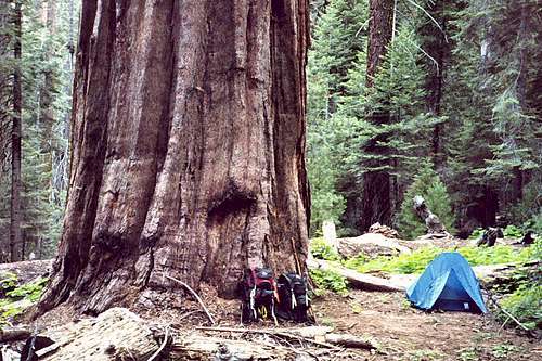 Camping under a Giant Sequoia.
Hiking
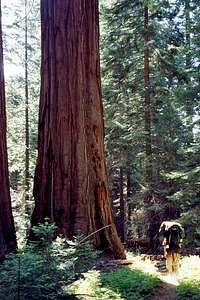 A Walk Among Giants.
The area has been the subject of extensive study of the impact of forest fire on the Giant Sequoias. You’ll see evidence of fire damage and recovery from prescribed burns along some of the trails. You’ll want to stop at the occasional rock outcropping to just admire the beauty of the surrounding forest, and take special note of the density of Giant Sequoias (easily identified by their rounded tops when looking out over the forest). But it is the close-up experience with these magnificent specimens that will stick with you. The Giant Sequoias have an average height of 150-280 ft, and are 16-23 ft in diameter. The bark of these trees is up to two feet thick. And the oldest known trees are over 3,200 years old.
This area is also populated with Sugar Pine trees. You might wish to know that the typical Sugar Pine may be taller than the surrounding Giant Sequoias, and will have a larger pinecone (in fact, the largest of any tree in the world). The sound of a 2-foot pinecone falling up to 250 feet is loud, long-lasting and memorable, to say the least! Because of this, the forest will be alive with noise all day. But at night the forest will become eerily quiet. After the cacophony of the daytime it’s almost surreal, and makes the experience of camping among these living giants all the more fascinating.
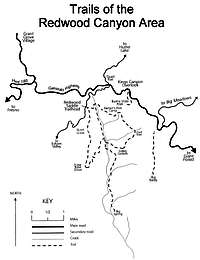
NPS Map of Trails in Redwood Canyon.
Specific hiking routes include:
Sugar Bowl Loop. This 6.4-mile loop is sometimes referred to as the "grove within a grove". It is particularly enjoyable because of the high density of young, Giant Sequoias. Following the trailhead sign to the right, ascend a ridge of Redwood Mountain for 1.5 miles where a series of switchbacks lead to an overlook of Big Baldy.
 Tunnel Tree.
Hart Tree and Fallen Goliath Loop. This 6.5-mile loop provides lots of vista points and a taste of the human history that are part of the Redwood Canyon experience. Follow the old dirt road .3 miles to the trail sign. Turn left and cross fern-lined Redwood Creek. Barton's Post marks the remains of an old logging site from the 1800's. The trail continues past lovely Hart Meadow and through the Tunnel Tree, a hollowed out Giant Sequoia. At 3.2 miles you will reach a spur trail to the largest tree in the grove, the Hart Tree. After passing a small waterfall, you will soon encounter Fallen Goliath.

USGS Quadrangle topo extract.
Redwood Mountain Loop. This 10-mile loop is a hike that combines both the Sugar Bowl and the Hart Tree Loops. It makes for a good dayhike or a nice overnight experience.
There are two additional trails that don't take the hiker into the canyon, but do provide nice views of the canyon. Follow the instructions to the trailheads below:
Buena Vista Trail. This easy, 2-mile hike provides great views of Redwood Canyon, Buck Rock and the high peaks of Kings Canyon. The trailhead is 6 miles south of Grant Grove on the Generals Highway, and on the right just past the Kings Canyon Overlook. The trail rises 450 feet in elevation and passes through several wildflower areas, and some beautiful stands of Jeffrey Pines.
Big Baldy. This 4-mile hike follows the Big Baldy Ridge. It will reward the hiker with more wonderful views of Redwood Canyon and the high country peaks. Drive south on the Generals Highway for 8 miles to the Big Baldy Trailhead. The 600-foot elevation gain to Big Baldy (8,209 feet) affords a dramatic, 360-degree panorama.
Additional Information
The following items could be useful for the prospective adventurer in Redwood Canyon, Kings Canyon National Park:o Trails Illustrated® map #205, Sequoia/Kings Canyon National Park
Excellent topo map of the two parks. However, limited detail in Redwood Canyon; take the maps included on this page, too.
o National Geographic Guide to the National Parks of the United States
This "tourist guide" is useful for planning a trip to any of the national parks. This is the book to take in the car with you as you visit each park. It will help you locate frontcountry campsites, make reservations, find a good restaurant, research phone numbers, etc. You'll still need to do additional research for more typical SP activities (backpacking, mountaineering, climbing, etc).
Additional information may also be obtained by calling the visitor center at (559) 565-4307.
External Links
o National Park Service Sequoia-Kings Canyon National Park Home PageLots of info about the two parks at this official website.
o Wilderness Permits and Reservations
NPS information on wilderness (backcountry) permits and reservations.
o Wilderness Permit Reservation Application (.pdf)
NPS application for a wilderness (backcountry) permit.
o NPS Camping Info
Direct link to NPS front country camping information.
o General Grant Grove Quadrangle Topo Map (.tiff)
Quick link to the USGS General Grant Grove quadrangle that includes Redwood Canyon. This large file is used under the Creative Commons License.
o Protecting Food While Backpacking
Describes bear procedures specific to Sequoia-Kings Canyon.
o Wikipedia Kings Canyon National Park Entry
Background information on the parks: Geography, history, etc.
o Wikipedia Sequoiadendron (Giant Sequoia) Entry
Background information on these magnificent trees: Distribution, ecology, cultivation, etc.
tarol - Jan 10, 2007 10:02 pm - Voted 10/10
Small correctionJust noticed your map link is right but the title is wrong... it says Black Canyon of the Gunnison.
Mark Doiron - Jan 10, 2007 11:02 pm - Hasn't voted
Re: Small correctionThanks, Sequoia! I copied some of the stuff from the Black Canyon page and obviously overlooked fixing that. --mark d.
tarol - Jan 11, 2007 12:47 am - Voted 10/10
Re: Small correctionNo, problem, I'm sure I've done the same before! And I know I appreciate another set of eyes looking at something to make sure it's correct...