
-
 13744 Hits
-
 90.48% Score
-
 32 Votes
|
|
Route |
|---|---|
|
|
37.68940°N / 107.602°W |
|
|
Hiking, Mountaineering, Trad Climbing, Big Wall, Scrambling |
|
|
Summer |
|
|
A long day |
|
|
5.7 (YDS) |
|
|
III |
|
|
Overview
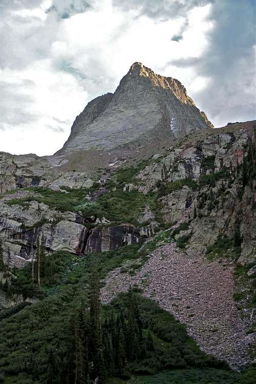 View from our camp in Vestal Basin
Vestal Peak is a lovely peak situated in a high alpine basin with a number of other high 13ers including Arrow Peak, the Trinities, Storm King and Electric Peak.
Vestal Peak lies within the Grenadier Range.
The Grenadier Range is an 8 mile long ridge that runs east-west between the Animas River and Vallecito Creek. The range is distinct from the rest of the San Juans because it is made of quartzite.
The primary access routes to this area are via train from Durango, exiting at the Elk Park area. From this point a good trail leads approximately 4.5 miles to the basin.
An alternate access is by Molas Pass, though this involves over 40 switchbacks, with an initial descent to the Animas River and railroad tracks.
The imposing Wham Ridge is a lot less intimidating to climb than to look at. The rock is outstanding.
Vestal Peak and Wham ridge have become a Colorado classic, since their first ascent in 1941 by CMC (Colorado Mountain Club) members. It’s easy to see why. On smooth slabs of quartzite, the rock is a joy to climb. Several lines exist up what is really a triangular face rather than a ridge, with the easiest being no harder than low 5th class, and the hardest rated as 5.7. But it is possible to get into trouble, especially if the weather threatens, so bring a rope.
The classic route up the Wham ridge starts in the middle and crosses towards the right arête (see photo and route description).
A slightly more technical route exists, which goes right in the middle of the face – Center Shift is the name Gerry Roach uses in his 13ers guide book. The center of Wham Ridge provides harder climbing. If you follow the path of least resistance, you can keep the difficulty at class 5.6. If you take a direct line up the center of the smooth face, you can climb some detectable and protectable class 5.7 pitches.
Most parties descend off the south face down the prominent gully, loose and grungy in spots, until they can traverse around to the Arrow-Vestal saddle and hike north and then descent into the camp. So, basically you get to ascend the north face and descend the south face of the mountain. Vestal's north face is very solid, but the south face is surprisingly loose, and a casual misstep can quickly launch a fatale missile. Be cautious of loosening rocks on climbers below you and keep helmets on for safety.
Getting There
Vestal Peak is only 9 miles southwest of Silverton, but it feels very isolated.Trailheads: Elk Park Trailhead - elevation: 8,860 feet, accessed via the Durango & Silverton Narrow Gauge train. Expensive, but very unique way to start your trip. No pets allowed.
Molas Lake Trailhead - elevation: 10,620 feet, located along the highway 550, which is the main and only highway between Durango and Silverton, well signed turn off for Molas Lake is hard to miss. This trail drops down 1,760 feet towards the Animas River (nice foot bridge across the river) and railroad, over 3 miles, and more than 40 switchbacks. It joins with the Elk Park trail about 0.25 miles from the railroad tracks.
The trail is well maintained and is part of the Colorado Trail. There is a sign for the Weminuche Wilderness area and sign in registry. Follow this trail up Elk Creek for 2.8 miles to large beaver ponds. There are a few campsites along these ponds with amazing views of Vestal and Arrow Peak.
Follow a faint trail along the east end of beaver pond and into a clearing on the south side of the ponds, again several nice campsites are located here. The trail re-enters trees and drops sharply down to the banks of Elk Creek. Find a spot to cross the creek - several large logs will help you. Continue up the trail, which starts to climb steeply up. The trail is easy to follow, you have to go over and under many logs. You will be hiking along Vestal Creek and at 11,400 feet you will come to Vestal Basin. It is hard to camp right along the creek - many willows, but there are nice campsite on little rock outcroppings offering spectacular views of the surrounding mountains.
From Elk Park TH: distance 12.8 miles and 5,244 ft elevation gain
From Molas TH: distance 19.4 miles and 6,924 ft elevation gain
From Vestal Creek/Basin: distance 3 miles and 2,464 ft elevation gain - this is where most parties camp.
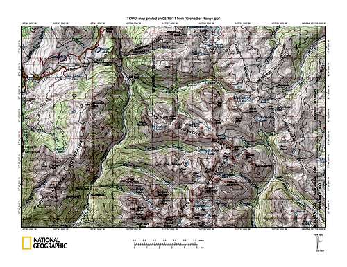 Greandier Range TOPO Greandier Range TOPO | 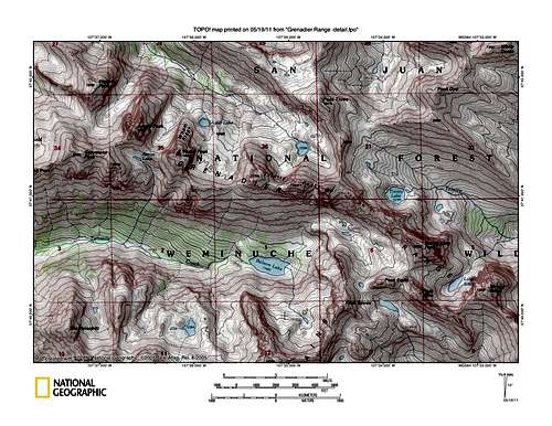 Grenadier Range TOPO detail Grenadier Range TOPO detail |
Route Description
First, you have to get to the base of the climb. We camped at the Vestal Basin, so I will start with a brief description of the hike to the base of the ridge, or rather Vestal's north triangular face.Follow the main trail into the basin along the Vestal Creek east, soon you will see a faint trail turning off south, located about 120 meters west of the wooded area. Follow this trail, cross Vestal Creek and gradually climb up to the relatively flat basin between Arrow and Vestal peaks at about 12,150 feet. From here head southeast towards the middle of the triangular face of Vestal Peak. There are some nice meadows with beautiful wildflowers in the mid summer. Vestal Lake will be on the east side of the Vestal Peak.
 North triangular face and wildflowers North triangular face and wildflowers |  Vestal Lake on the east side Vestal Lake on the east side |
Climb: Choose the mid section of the Vestal's north triangular face, and follow the path of the most comfort up. The classic route up the Wham Ridge also starts in the middle, but then crosses towards the right arete. So, stick to the middle, there are number of lines you can follow, and plenty of opportunities to place protection.
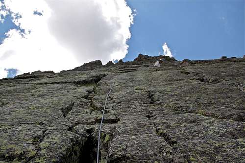
We started climbing in our approach shoes (I had running shoes), and got 2/3 up the ridge without feeling uncomfortable. We roped up for the last 1/3, and changed into rock climbing shoes. I can't describe how many pitches we climbed since we did 3 pitches on 60 meter rope (placing only 1-2 nuts en route), and then we simu-climbed the rest of the route. Simu-climbing means that both climbers are moving together while having about 2 pieces of protection in between (more on difficult walls), and trying to keep rope fully extended. The face wall is huge, so you can choose plenty of little cracks to follow, and many little ledges give you places to rest. Most moves were 5.4 to 5.6 range, and I felt that one has to actively seek for the 5.7 moves described in books.
The climb finishes at the top of false summit of Vestal Peak, and you have to descend slightly about 25 meters, and scramble up class 3-4 section to its main summit. The views from the top are SPECTACULAR.
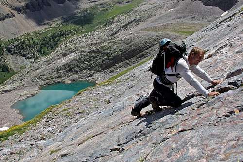 Nice solid rock made the scramble/climb easy Nice solid rock made the scramble/climb easy | 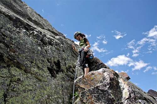 Fun and joy in the high alpine setting Fun and joy in the high alpine setting |
 about 3/4 way up about 3/4 way up |  I can make it look hard I can make it look hard |
I would estimate that we did about 5 pitches only, but I read descriptions of 10 pitches using 70 meter rope. So, it all depends on your comfort level when you will rope up and start climbing instead of scrambling/free soloing. Most climbers agree that rating is easier than 5.7.
Summit
What a feeling when one reaches a high summit. It is so hard to describe, for some it becomes an addiction.Summit is 13,864 feet, which is 4226 meters.
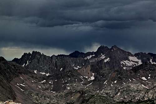 Storm over Needle Mountains Storm over Needle Mountains | 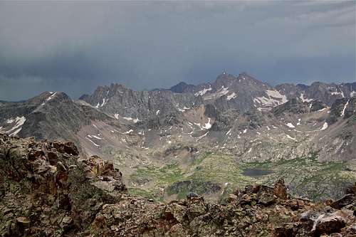 and Needles again, overwhelming feeling, so many mountains to climb and Needles again, overwhelming feeling, so many mountains to climb |
Descent
Reaching the top is only half the effort and the most accidents happen on the way downWe reached the top, and the weather started to deteriorate rapidly. We thought what a deal, we will just run down the easy route, but it ended up being more demanding than we expected. There are 2 cairns on the summit ridge of Vestal Peak marking your start for the descent. It appears confusing initially because you are descending south, completely opposite from your return destination. There is not trail, no cairns, just a lot of loose rock, and it appears for a long time that you are dropping into a totally different basin. You will eventually end up in a prominent gully and at the end of this gully you need to traverse west, towards the Vestal-Arrow saddle. You will be able to see Arrow Lake and of course dramatic views of Arrow Peak. The whole descent is very loose. Even the descent from the saddle is on very loose scree, which likes to create rock slides under your feet. Keep going between Arrow Peak and Vestal Peak until you join the trail, which leads to Vestal basin below you.
 Descent from Vestal Peak on South face Descent from Vestal Peak on South face | 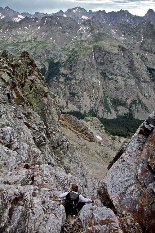 Southeast couloir Southeast couloir |
Essential Gear
BUG SPRAYRope of any length between 30 to 60 meters (30 meters would be enough for 2 person simu-climbing)
Comfortable shoes, approach shoes would work great here, rock shoes if you wish to carry an extra weight (you definitively need some comfortable footwear for the descent)
Harness - light alpine sufficient, or tying rope around your waste for the minimalist
Protection - a set of nuts and slings
Helmet - solid rock on the way up, but very loose on your descent via south-east couloir.
 Our gear, please note Czech Slivowitz= home made plum brandy Our gear, please note Czech Slivowitz= home made plum brandy |  Good shoes and rain protection in the pack Good shoes and rain protection in the pack |