
Comments
No comments posted yet.
|
|
Trip Report |
|---|---|
|
|
39.63855°S / 71.50243°W |
|
|
Nov 30, 0000 |
|
|
Hiking, Mountaineering, Scrambling |
|
|
Summer |
Note this is the second installment of my trip to South America in February and March, 2015. To see Part 1 click the link at right! Argentine Chronicles Volume 1 - Nahuel Huapi National Park
After thoroughly exploring Nahuel Huapi National Park (described in previous trip report), I narrowed in on the area surrounding Pucon, Chile. I made plans to take the international bus from San Martin de los Andes towards Temuco passing over the international border just north of Lanin, however the eruption of Villarrica, which sits directly above the town of Pucon decided to erupt and the crossing was closed. Since it would likely be closed for a few days I had no choice but to take buses back south and return to Osorno. This would unfortunately take a couple days so I figured I could relax awhile and bus from one town to the next. So I ended up getting a ticket to Villa la Angstura and stayed there for a night at a very nice hostel. Walking through town that afternoon I was bit by a dog (although I look back now and it was more of a nibble), nonetheless, it gave me a rabies scare so I went to the local doctor but since no one there spoke English it was hard to communicate. Finally I understood using Google Translate that there has never been a case of rabies anywhere near the area. I then walked back to the hostel and enjoyed a nice dinner (pizza again!) at a local shop that seemed to have issues with their power since the power would go out every 20 minutes or so.
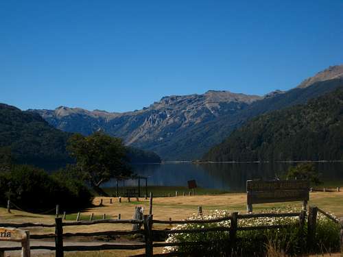 Views from the bus to Villa La Angstura
 | 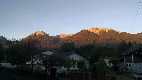 Villa La Angstura
 |  Villa La Angstura
 |
The next morning I got a ticket across the border to Osorno. The ride to the border customs was short but since we were returning into Chile, the customs agents were much stricter in searching everyone's' bags. It took over an hour to have everything searched and passports stamped. I was the only one who spoke English there so spent lots of time daydreaming haha. Sometime in early afternoon we got to the bus station in Osorno and I got some Empanadas and a hot dog from the street vendors (I try to support them) before walking to the hospital across the street. To my dismay, no one spoke English there either so I struggled to find out how I could get a rabies shot (I wanted to be ultra safe). Luckily one of the women working there called up her son for me who spoke English and I was able to talk with him. Once she figured out what I wanted, I was able to get the shots and be on my way. Surprisingly they were free!
I waited another hour at the busy bus station and got on the bus to Pucon. A few hours later (10pm!) I got to Pucon and found an excellent hostel along the shore of the lake called Chili Kiwi. I was very surprised to see literally everyone speaking English inside, and it was nice to hear the stories of everyone's travels. The owner was Australian and many people there actually didn't even speak Spanish. I met up with a few planning to hike Cerro San Sebastian the next morning which coincidentally was my exact plan. The weather was looking great for the next day and there was also a small bus that went into the Parque Nacional Huerquehue! Finally I was in Chile and ready for my next hike after what seemed like days on buses.
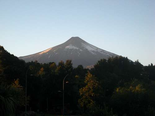 Villirrica 3 days after it erupted
 | 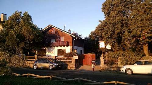 Chili Kiwi Hostel in Pucon
 | 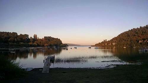 Evening on Lago Villarrica
 |
The map I had of the Pucon area said that this peak, which had a nice trail all the way to the top, was the highest point in the park so it would be a nice way to see the surrounding landscape. We all got breakfast at the bakery a few blocks from the hostel on our way to the bus station and all got aboard. I think it was 5,000 Pesos for a round trip ride. Our group consisted of a guy from New Zealand, a girl from New York, a girl from England and myself. Upon arriving at the trailhead, I was annoyed we had to not only pay an entrance fee, but also had to sign in with the ranger. Luckily he didn't insist on checking our gear but we were delayed an hour or so waiting for everyone to sign in and pay the fee.
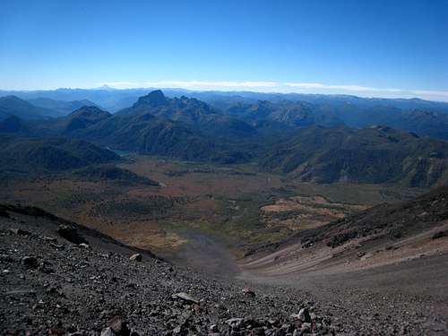
Around 10:30 am we started up the trail which was through very nice old growth forests and bamboo shrubs. It was a cool, shady hike up to the broad south ridge of San Sebastian. At a signed junction in a large meadow we took a nice break and enjoyed our first views of Villarrica and Lanin. The trees on all the slopes here were very odd and I had never seen them before. They had very sharp points and resembled palm trees a little bit and I actually had to avoid touching them. As we continued up the trail, we descended slightly and re-entered an old growth forest. The trail began ascending steeply up the south ridge and as we gained elevation some of the plants and grasses began showing hints of fall color. Since this was early March it was the equivalent of early September in the northern hemisphere when colors first start appearing. Eventually we reached treeline and had to pass through two very steep sections under dense bushes similar to slide alder found in the Cascades. Veggie belays were required and the trail was very dusty. Beyond that it was an easy hike over boulders with one tiny scramble spot and a pleasant walk to the summit. To my disbelief, the summit just to the east was slightly higher and my map had lied. Looking at the map provided by the ranger though, it showed the correct elevations and San Sebastian was indeed the second highest point in the park. Regardless, the views were still astounding. With Lanin and Villarrica to the south and other volcanoes to the north, a large area of central Chile was visible under the crystal blue, cloudless sky.
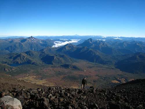
We stood on the summit for over an hour by ourselves and I admired the views before starting down. I was able to get down very quickly and had enough time to take a dip in the lake near the picnic area before the bus arrived which was very nice since it had warmed up substantially and was outright hot. We all managed to catch the bus on time and return to Pucon with plenty of time for dinner and to hang out at the hostel.
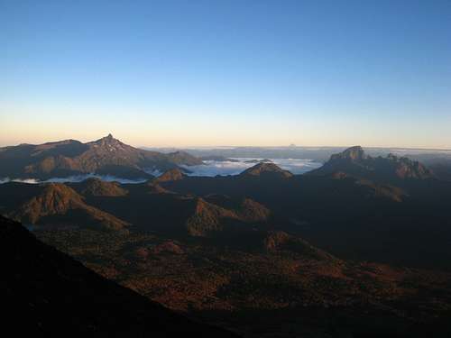
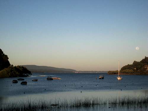 Villarrica Lake at sunrise
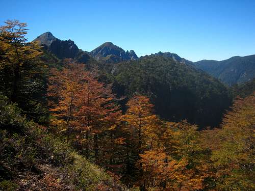 Fall foliage in early March
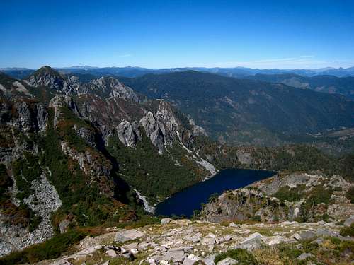 Alpine lake below San Sebastian
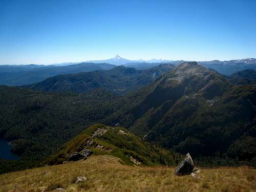 View north from the summit
 | 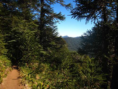 Trail to San Sebastian
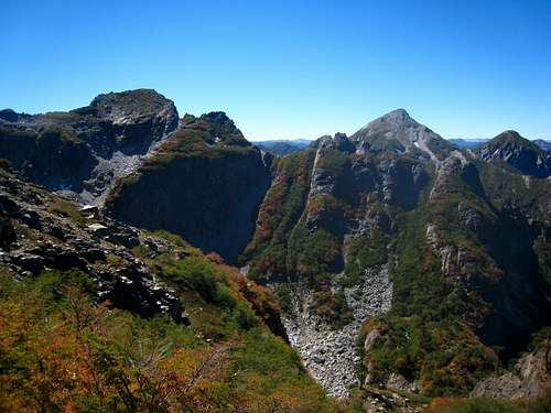 San Sebastian
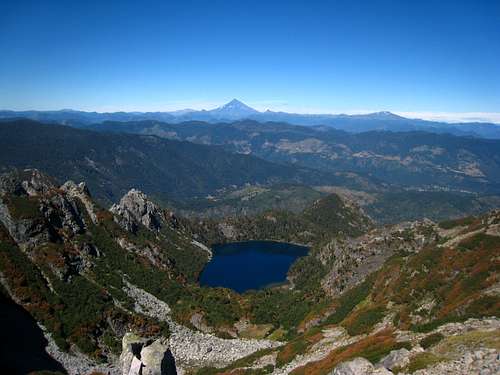 Alpine lake below San Sebastian
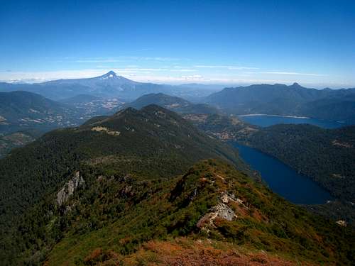 Looking down another ridge from the summit
 | 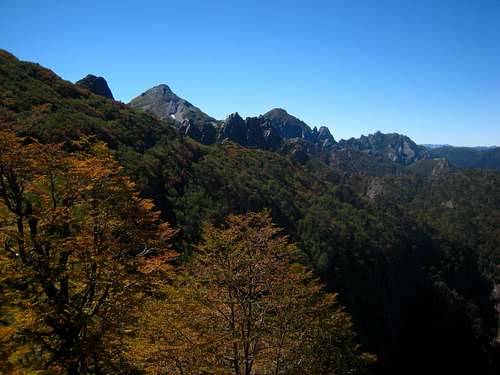 Hiking up San Sebastian
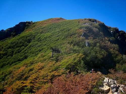 The start of fall on San Sebastian
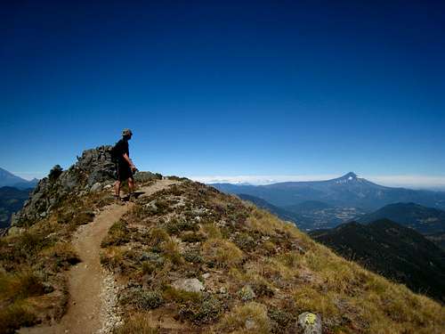 Nearing the summit of San Sebastian
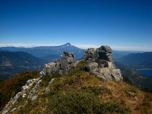 On the summit ridge to San Sebastian
 |
The next day it was somewhat drizzling so Markus and I spent the morning working out plans for our ascent of Lanin. I met him at the hostel and is from Germany. We decided since renting a car was so cheap we would do that and drive up towards the border but just before the guard station, turn off onto the dirt road heading towards the volcano. At about 5pm we got a car from Pucon Rent a Car which was only 22,000 Pesos per day ($35) and drove east. As we headed east the clouds began to get thicker and just as we arrived at our trailhead it started to rain. We noticed there was road work being done and realized they were dumping large amounts of dirt and rock in the large area at the end of the road we parked off. I was worried a 4 wheel drive would be required but since they had improved the road for trucks we were easily able to drive the whole way up! We walked around for a few minutes and located the trail through the trees which would provide easy passage to the start of the scree at the base of the mountain.
Since the rain picked up as it got dark we just slept in the car. Luckily the seats went down far enough and we both were able to get some sleep. I recall only waking up once around midnight to see the bright moon out and clear skies. I will admit I was getting worried it wasn't going to stop raining...I rested easier for a few more hours after seeing the sky clear but the full moon sure made it hard to get back to sleep. At 4:30am the alarms went off and we were pretty quick to be up and hiking. We made quick time to the formal base of the mountain and started hiking through baby-head cobbles which then transitioned into loose scree. We passed to the right of the waterfall I had read about but couldn't see it in the dark. Luckily we weren't able to see what we were ascending or we may have turned around right there but above us was a huge, broad scree gully rising something like 4,000 feet and to my dismay upon looking at the map on my phone only reached halfway up the mountain!
 Sunrise from the endless gully
 | 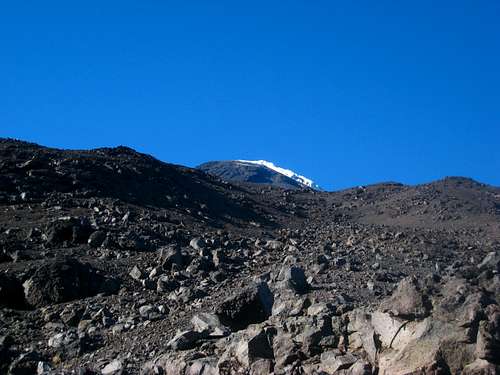 Hiking up the loose gully
 | 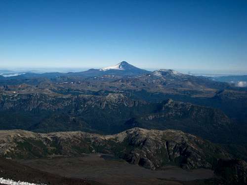 Villarrica from the slopes of Lanin
 |
As dawn started to come upon us, we were maybe 2,000 feet above the car slogging our way up the scree which was slowly getting steeper. At sunrise we were on maybe a 30 degree slope but the wonderful views to the north made us forget about the awful crap we were walking on. All I kept saying was that it would be fun to go down on our way out. About halfway up the dubbed "endless gully" the scree got worse and before long we weren't getting any upward push anymore. After a few hundred more feet I spotted a route that would potentially take us to the ridge to our left and hopefully more solid rock. Pssh solid rock on Lanin? What a joke!
So we cut left and managed to plow our way to the edge of the gully and scramble up but what I saw was two more gullies and ribs seperating us from the ridge I wanted to be on where I could clearly see some more solid rock. So we traversed across another loose gully toying death with scores of microwave sized death blocks teetering overhead. I led the way being exceptionally careful to keep all rocks in their place while Markus followed. Some Class 3 scrambling ensued to gain a small cliff band and eventually we reached the ridge where we were able to breathe easier and continue upwards with some solid ground. Maybe just 800 feet higher the terrain mellowed out and we reached a broad area of nothing but talus and scree but the going was substantially easier for awhile. We finally were able to see the summit and realized we probably were only halfway up and at this point it was almost noon. Around 1,000 meters below the summit Markus decided to call it a day when we came upon a nice bivy spot with flat, sandy ground. I took a half hour break to eat, drink and re-apply sunscreen before continuing on.
 Markus Ascending Lanin
 | 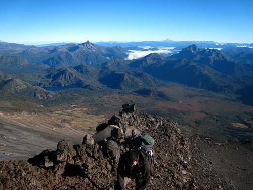 Scrambling the ridge on the Chilean side of Lanin
 | 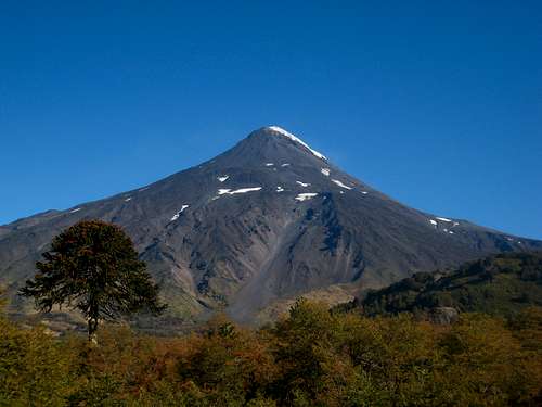 Full view of Lanin from the highway
 |
The next 500 meters was up more talus until I reached the final section of the climb which consisted of steeper scrambling with immense amounts of loose rock. From below I wasn't able to spot a good looking route but now that I was up only 500 meters from the summit the best way was obvious. I had to avoid the gullies as much as possible so I stayed on small ridges which amazingly had some solid rock. Lots of Class 2+ scrambling ensued and eventually I noticed a large, guided group of 8 people maybe 500 feet above me who were headed down. All I could think was "oh great" as now I was right below them as they threw bowling balls (rocks) down on me (the pin). Luckily I was able to cut right onto another small ridge and get out from their fall zone and continue climbing and scrambling. I reached them right as they were all down climbing one of the tricky spots one at a time. They were moving very slow and dressed in full gore-tex clothing with stiff boots and huge gloves. I laughed inside as I was in my light sweats and a T-shirt without sunglasses or gloves on. I mean, sure Lanin is a big mountain and all but it was in the 60's and no wind to speak of on this beautiful day not to mention it was early March so there was not a single iota of snow on the route!
One of the guys asked where I had come from and I responded with a stern "The Chilean Side" and smiled. We exchanged where we were from and I continued on scrambling with extra care now that I would be above them. I actually stayed to the right to avoid being above them and before I knew it I was on the summit which turned out to be a huge area. I reached the highest rocky point then walked north for maybe 50 yards onto the glacier to the highest point where I was able to see Tronador, Osorno and other peaks of the Lake District. I looked at my phone and it was slightly after 3pm. "Plenty of time" I spoke as I relaxed on the summit, wishing now I had my sunglasses (which if you read my first trip report would know they were stolen, along with lots of other gear I had including my gloves, which thankfull were not needed).
Villarrica from the slopes of Lanin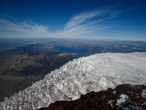 View east from Lanin
 | 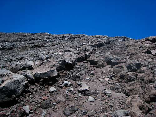 Scrambling on the last 300 meters of Lanin
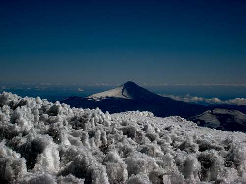 Villarrica from Lanin with the north side covered in ash
 | 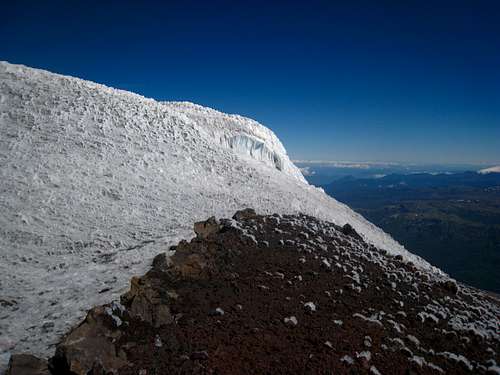 Summit of Lanin
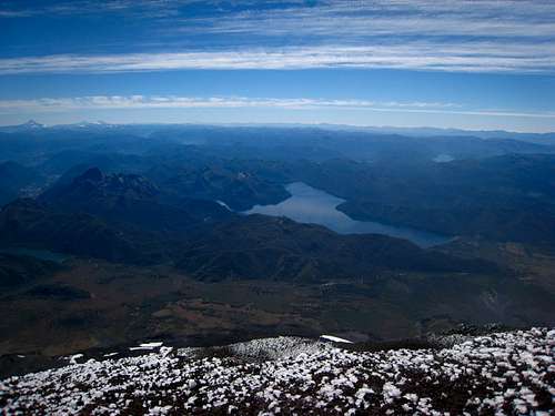 Lake Tromen from the summit of Lanin
 |
It was very bright on the summit so I didn't stay too long. Snapped some photos of Villarrica, Tronador and the surrounding scenery and started down. I found the main trail and started down it which was much easier than the scrambling I had done on the ascent. Within minutes I caught back up with the large group and thought to myself "god they're slow" and quickly passed them and began trending back to skiers left to stay in the Chilean side. The standard Argentina route and the Chilean route actually meet and follow the international border for the final 500 meters or so to the summit.
Carefully, I scrambled down the small ridges and reached the talus below and within an hour of leaving the summit I met back up with Markus. He mentioned how eerie it was to be alone on a mountain for a few hours and expressed concern for the descent. I assurred him the descent would be fairly quick and actually fun since we could slide down the scree like we were skiing...kinda. So I took another break to eat (I was glad I brought a lot of food!) and we started down the mountain back to the car. Nearly 3 hours and 4 painful knees later we reached the car and caught some great lighting on the mountain as we finished the hike and started driving away.
 Descending the gully of no end
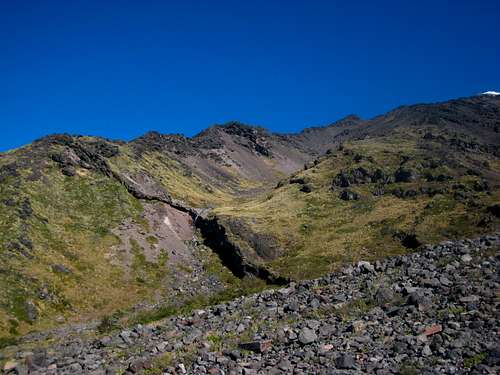 The waterfall near the base of Lanin
 | 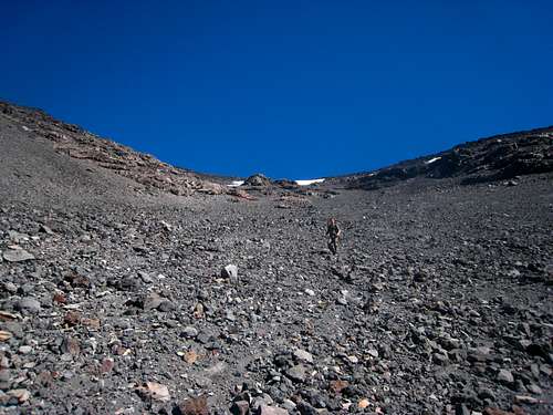 Descending the gully of no end on Lanin
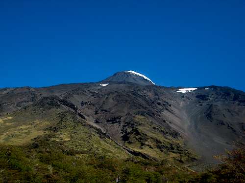 Lanin with the long gully to the right
 | 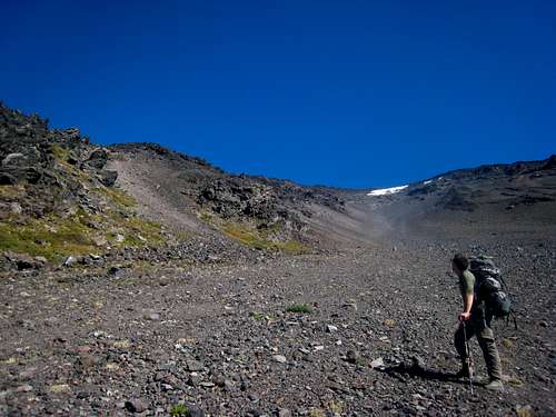 Looking up the long, loose gully on Lanin
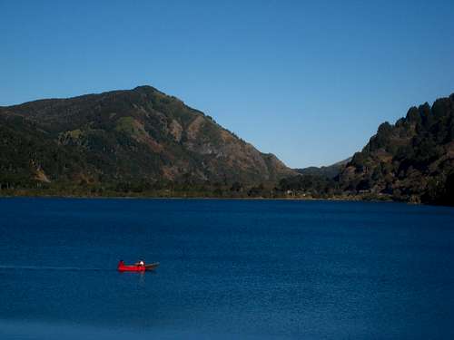 Boater on Laguna Quillelhue
 |
We did a "warm down" walk along the lake a few miles down the road and drove back west towards Pucon. We struggled to find a place to camp and tried nearly a dozen different gravel roads with no luck. Everything seemed to be private property but just as it got dark we found a secluded place behind an old barn that offered some solitude from the houses across the pond. A satisfying dinner and copious amounts of beer immediately followed. We enjoyed the warm night sleeping under the stars and was surprised at how many meteors we saw.
After sleeping in the next morning, we drove back to town and returned the rental car. The start of my long return back home would begin that afternoon so I showered at the hostel, packed everything up and enjoyed the final couple hours in the sun along the shore of Lake Villarrica before wishing Markus an enjoyable rest of his trip and walking to the bus station. My return home consisted of the equilivent of hell. See below for details:
3 hour bus to Osorno, 12 hour bus to Santiago, 12 hour wait for my flight, 9 hour flight to Miami, 4 hour flight to Denver, and a 6 hour drive to Salt Lake City where I met Jayme and we were able to crash. After that Jayme and I enjoyed a few nice days in the Utah desert before driving back to Bozeman but that is part of another story.