
|
|
Mountain/Rock |
|---|---|
|
|
46.58315°N / 12.29111°E |
|
|
Hiking, Mountaineering, Trad Climbing, Scrambling, Via Ferrata |
|
|
Spring, Summer, Fall |
|
|
9147 ft / 2788 m |
|
|
Overview
The area of the "Cadini di Misurina" including Cima Cadin Nord-Est is located slightly to the south of the famous "Tre Cime di Lavaredo".This area has been made available in the same quality from a touristy point of view, but it is less crowded - so you might enjoy your hikes and climbs even more...
There is a good path network and most of them are well marked.
This is a really nice and rewarding hiking- and climbing-area above the Lake Misurina.
For additional general information check the parent-page Cadini di Misurina, too.
The highest peaks of the Cadini di Misurina above the cwm "Cadin del Nevaio" are Cima Cadin di San Lucano (2.839 m), Cima Eötvös (2.825 m) and Cima Cadin Nord-Est (2.788 m).

Looking up the cwm "Cadin del Nevaio".
The latter has a "secured" ascent, the so called Via ferrata Merlone.
The most important thing or "skill" for this ascent is to be free of giddiness...
In the route you will find a series of ladders with app. 300 rungs.
There is a constant rock-fall danger on this route - especially, if several climbers or teams are on the route at the same time.
But the ascent is not without charm: the summit view is very impressive and atmospheric, the evident eye-catcher in the north is obviously the view to "Tre Cime di Lavaredo".
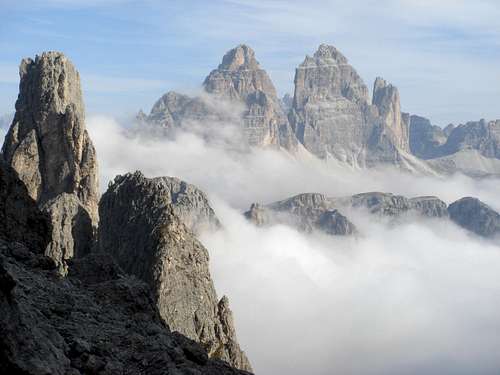
"Tre Cime" seen from the approach to Cima Cadin Nord-Est, above "Fonda Savio".
You can enjoy the not so famous – but as well beautiful - view of the "Tre Cime" from the south.
Getting There
Follow the well-known "Tre Cime" road until you reach the junction to a narrow forest track (Sign "Rifugio Fonda Savio", to the right) - app. 1 km from the Misurina pass.The street leads in a few serpentines up to "Pian degli spiriti" (1.896 m), where you will find a parking lot (or you can park already at the junction and walk the few meters, which I would recommend).
There is no toll, because the junction is fortunately located already before the toll station, which you pass when heading to "Tre Cime" :o)
Routes Overview
There are several climbing routes to reach the summit.- east wall (the Crepaz route)
- south wall (the Casara route)
Additionally this peak offers an interesting "Via ferrata" following the west pillar (called Via ferrata Merlone) as one possible ascent.
Although this route is sometimes mentioned as a negative example of over-developed ascents (with all it's ladders and rope support), it is a nice ascent anyway (considering that it was already built in 1966).
As long as this type of route is not too often built in the dolomites and in the whole alps, it is ok to give non-climbers the chance to reach some - otherwise for them not possible - mountains, too.
Summit views:


When To Climb
The best time is June to OctoberMountain Huts
Rifugio Fonda Savio (2.367 m), open during summer.You reach the hut from the junction mentioned in the "Getting there" section on the marked trail 115 in less than 1,5 hours.

The hut is located on a beautiful place, directly on the Tocci pass with "Cime Cadin dei Tocci" and "Tre Cime di Lavaredo" in the background.

More information (like phone number etc.) on the web: Rifugio Fonda Savio (in italian only)
Literature
Maps:TABACCO (sheet number 03) "Cortina d’Ampezzo e Dolomiti Ampezzane" (1:25.000)
Or in addition sheet number 10 or 017 (depending, on which surrounding areas you are interested in).
gimpilator - Nov 29, 2015 12:31 pm - Voted 10/10
Coordinates GlitchI just stumbled onto a strange glitch which corrupted the location of numerous pages and listed them all at the same point in southern AZ, USA. Please fix the coordinates of this page and I'll be happy to remove my "needs updates" vote. Thanks!
Herb - Nov 30, 2015 5:48 am - Hasn't voted
Re: Coordinates GlitchThanks for the hint. I've updated the coordinates. Cheers, Herbert