-
 3050 Hits
-
 78.27% Score
-
 9 Votes
|
|
Mountain/Rock |
|---|---|
|
|
45.69090°N / 11.10673°E |
|
|
Hiking, Skiing |
|
|
Spring, Summer, Fall, Winter |
|
|
6119 ft / 1865 m |
|
|
Overview

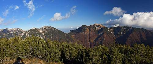
The highest summits of Monti Lessini have many similarities. They are all aligned along the northern border of the massif, on the edge, where Monti Lessini abruptly fall down into the deep Val Ronchi. But southern sides of all these mountains are gentle and grassy. Actually they form an impressive, very picturesque high plateau, above which the following bumps are rising: Monte Castelberto, Monte Sparavieri, Monte Tomba, Castel Gaibana, Cima Trappola and some others, a bit lower ones. This is the 'true Lessinia' - see the parent area page for the description about this area and the eastern mountain chain. So, this Lessinia is bordered on the east with the quite deep Val d'Illasi, the upper part of this valley is called Valle di Revolto. And Cima Trappola rises as the highest elevation of this Lessinia just in the corner - Val di Ronchi on the north and Valle di Rivolto on the east are coming together on the saddle, called Passo Pertica, north of Cima Trappola.

Not much further description of the area is needed. The western neighbour of Cima Trappola is called Castel Gaibana - a few rocks, rising out of the grassy summit make a castle-like impression. This summit is reached by a chair lift, coming from the modern tourist resort San Giorgio, 1500 m. On the Castel Gaibana also a restaurant stands. From the Cima Trappola towards the south a distinct ridge runs. Its eastern slopes are steep and densely overgrown with dwarf pines, while its western slopes are gentle and grassy - just an appropriate ridge for a hiking trail! Between the Castel Gaibana and the Cima Trappola ridge a high mountain valley called Il Vallone lies. In the upper part of this valley there's a sinkhole, called Buco del Vallone. It's some 50 m deep and on the bottom of the cave once there were thick layers of ice which was collected by locals and sold in the valley. The last to be mentioned is the nice alpine pasture, called Malga Malera. The whole area around and south of it can be an objective of a pleasant hiking or biking tour.
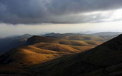
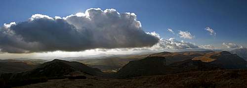
Summit views


From the Cima Trappola we can enjoy splendid, open views down the Lessinia massif, so towards the south and west. But come there in a clear day! The eastern views are more interesting for experts, who want to overview the eastern chain from the distance and in detail: Monte Plische, 1991 m, Cima Tre Croci, 1939 m, Monte Zevola, 1976 m, and Monte Terrazzo, 1876 m, in the SW branch. Towards the north we have interesting views in the Cima Carega massif, 2259 m, but the main summit is only hardly peeking out above the fore-summits.
Getting There
The most recommendable and by far most often used trailhead is San Giorgio, 1500 m. The ex alpine meadow developed into a modern tourist resort (hiking, mountain biking, alpine skiing, tour skiing, cross country skiing, horse riding...). It is reached by a good asphalted road. The second, more or less only theoretical possibility is the Rivolto valley. Who would only be negotiating those overgrown, 700 m high slopes to reach such a humble summit as Cima Trappola?
Hiking Routes

From San Giorgio we can ascend the Cima Trappola by many variants. Actually, all the western and southern slopes are passable everywhere. If we go first on the Castel Gaibana an unmarked path descends from that summit towards the NE, we lose some 60 m of altitude and then follow the good path up on Cima Trappola.

The quickest ascent goes from San Giorgio first into Il Vallone, then a bit right on the saddle between the Castel Malera and Cima Trappola and finally towards the N-NE on top. Easy hike (T2), 1 hour. The same if you don't go right, but just continue straight, passing by the Buco del Vallone (path is unmarked). And we can also go a bit around (or descend by this third option): From San Giorgio we go by the cart-road on Malga Malera and from there northwards to Passo Malera, 1722 m, and by the main ridge further on top. As said, from the eastern side the ascent would be a bit higher: more than 700 m of altitude (2 hours) from Rif. Boschetto and more than 500 m (1 h 30 min) from Rif. Revolto.
Mountain huts
Huts and other facilities are not needed to visit Cima Trappola. Deep down on the eastern side there are the two already mentioned huts, reachable by mountain road, on Castel Gaibana there's the Rifugio Gaibana.
When to ascend?
Cima Trappola can be ascended any time of the year. Even more so, as the road to San Giorgio is cleaned the whole year. The most beautiful seasons are - hmm - all four :) Each in its own way, as it holds true for the whole Lessinia.