Climbing North Trapper's Southeast Face
The Summit – 9,801’
Route Elevation Gain – 4,378‘
Distance – 7.4 miles
(total)
Difficulty – Class 4
Total Route Time – 11 hours 40 minutes
Ascent Date – 14oct06
![Morning Light on North Trapper]() Morning light on
Morning light on
North Trapper.
The first time I was on the summit of Trapper Peak looking over at the North Trapper summit, I thought,
“that is one mountain top I’m unlikely to ever visit.” That was several years ago, before I’d moved to the Bitterroot Valley. Now that I live here, I’ve spent quite a bit of time in the backcountry, mostly on my way to one or another summit. As I became more familiar with the Bitterroot Mountains and improved my mountaineering skills, I began to think that maybe, just maybe, I would try for North Trapper, someday.
![Tim the Route Leader]() Tim, our group's leader.
Tim, our group's leader.
That day came sooner than I though it might when I was invited to join a group from Missoula which was planning to make an attempt the second Saturday in October, weather permitting. Then, the weekend before our planned outing, the Bitterroots received several inches of snow, not an uncommon occurrence for October. I watched the weather during the first few days of the week, hoping it would stay warm and melt at least some of the snow.
After corresponding with Tim, the group leader, I hiked into the area of North Trapper on Thursday to get a feel for the current conditions and take a few pictures so he could gauge the situation for himself. After studying the weekend weather forecast in combination with my pictures, he judged the state of affairs to be good enough for an attempt. If it turned out part of the route was too dangerous, we would just turn back, something we all hoped that wouldn’t happen.
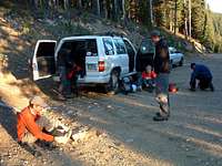
![Preparing for North Trapper]() Everyone is about ready.
Everyone is about ready.
8:10 am – We all met at the Baker Lake Trailhead, milled around for a few minutes introducing ourselves, then began getting ready to hit the trail. Our party included, Tim, the leader, plus Fred, Matt, Meleah, Vernon, and myself.
8:30 am – Finally ready, we hit the trail. Now, for those of you who are unfamiliar with trails in the Bitterroots, let me tell you they have a reputation for being steep, especially at their beginnings. The Baker Lake Trail is no exception. For 15 minutes it climbs quite sharply (about 400’ in .3 mile) until it reaches the Baker Point Overlook.
![Trail to Baker Point]() The trail to Baker Point is quite steep
The trail to Baker Point is quite steep
The overlook is a great spot to catch your breath and try to get your legs to stop trembling. On a clear day you can see the Beaverheads far to the south, even the Pintlers to the east. If you know what to look for, several other ranges are visible, too. I’d been here several times before and had taken many pictures. This time it was Vernon’s and Meleah’s turn to warm up their cameras. While they took pictures, several of us removed a layer or two then got back on the trail.
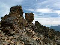
![Rocks on Baker Point]() Rock outcropping at
Rock outcropping at
Baker Point.![Boulders Along Trail]() Ready to Boulder?
Ready to Boulder?
As the trail traverses in a westerly direction along a ridge leading to East Trapper Peak, you get your first glimpse of Trapper Peak’s east ridge.
8:50 am – The trail passed a complex outcropping of boulders just uphill. This time I took pictures. Some Bouldering friends of mine wanted to see what climbing possibilities were offered by these rocks.
9:20 am – Most of us were on the eastern shoreline of Baker Lake by now. But somehow, two(2) of the strongest hikers were missing, Fred and Matt. We could hear them to the southeast and off-route. We yelled a few times to let them know where they were supposed to be, and in short order they arrived. It turned out they’d missed the cairns marking the way to Baker Lake and had instead followed the more obvious trail which would have taken them south to a ridgeline trail leading to Trapper Peak. Oops!
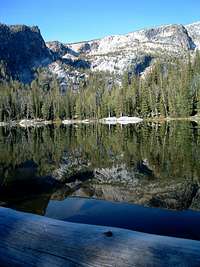
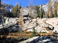
![Baker Lake]() The calm waters of Baker Lake.
The calm waters of Baker Lake.![Trail to Middle Lake]() The trail from Baker Lake to Middle Lake has improved over the last few years.
The trail from Baker Lake to Middle Lake has improved over the last few years.
9:45 am – We only paused a few minutes at Middle Lake, anxious to be on our way.
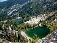
9:55 am – Gem Lake. It’s certainly a beauty of a tarn and aptly named. I think just about everyone carrying a camera spent a little time recording the scenery before we headed around the north side of the lake to begin climbing to the col, 290’ up a slope of talus, scree, brush, and a bit of deadfall.
![Gem and Middle Lakes]() Middle and Gem Lakes
Middle and Gem Lakes
from the col.![Climbing to the Col]() Vernon and Meleah climb toward the col.
Vernon and Meleah climb toward the col.
10:25 am – The last of us reached the col and spent time taking pictures while waiting for our hearts to slow to a more normal beat-rate. It was at this point that Tim set a mandatory turn-around time of 3:00 pm. Everyone agreed it was an excellent idea, and fair.
Tim explained what to expect while descending the couloir on the other
(north) side of the ridge and warned us about loose rock. Most who had helmets put them on. Hoping that we would only have to descend 200’ before exiting the couloir onto slabs, Tim and Fred descended first to assess our choices.
![Descending form the Col]() Descending the couloir to the basin.
Descending the couloir to the basin.
10:55 am – While Tim continued to evaluate possibilities for an exit route onto the slabs, the rest of us continued to descend to a specific spot and wait. It didn’t take Tim long to discover we would have to go all the way to the bottom of the couloir before heading toward North Trapper’s base. There was just too much snow and ice on the slabs and small ledges for safe travel.
![One of the Bitterroot s nicest basins...]() One of the Bitterroot's
One of the Bitterroot's
nicest basins.
From the spot where we had been waiting, part way down the couloir, to the base of North Trapper took us an hour and a half to cover. Once we reached the bottom of the couloir, our route first crossed a large field of talus and large boulders. It then progressed uphill toward the upper section of the bowl, climbed a few slabs, passed over bear grass interspersed with whitebark pine, larch, and scrub, onto an area of mixed bear grass and small rock.
This entire area is an absolutely pristine basin with its own rock/ice glacier flowing below and away from the slopes of Trapper and East Trapper Peaks. You are almost surrounded (270 degrees) by the granite walls of the three summits comprising the Trapper Massif (East Trapper, Trapper, and North Trapper Peaks). There is a year-round spring (technically glacial melt) to fill water bottles and many choice camping sites. Not one fire ring mars the entire basin (please keep it that way). It’s a good idea to disperse usage in pristine areas like this. Camping on the rock moraines to lessen the impact helps.
![Eating Lunch Before Ascent]() Lunch and a few words of instruction.
Lunch and a few words of instruction.
12:25 pm – We’d finally reached the base of North Trapper. The cameras came back out and we spent some time eating lunch
(if you want to call it that). Tim pointed out our route
(as far as it could be seen from that spot). Again, he warned about loose rock in the couloir we were about to enter.
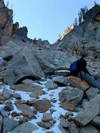
![Vernon on Descent]() The bottom of the coloir.
The bottom of the coloir.
12:35 pm – We began climbing the slope toward the base of the couloir. It turned out that even though the slope was a mixture of talus, bear grass, and scree, it provided fairly solid footing – none of that two steps forward one step backward stuff.
From the moment we entered the bottom of the couloir until we reached the ridge-crest, time stood still – we were expending too much effort to note its passage. What transpired during that hour and 35 minutes was as follows:
We climbed the couloir until we reached an elevation near 9,000’ where we exited the couloir onto slabs and traversed in a westward direction to about 9,200’ and the dike of black rock.
We then followed a small ledge along the lower edge of the dike as it traversed northeast across the face while gaining another 100’ of elevation by the time it reached a couloir
(which then rises nearly to the ridge-crest).
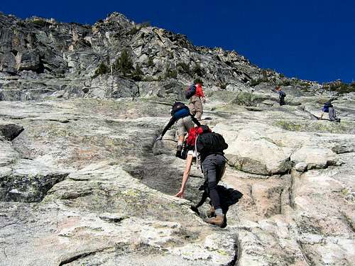
![Ascending the Granite Slab area...]() Climbing slabs toward the black-rock dike.
Climbing slabs toward the black-rock dike.![Good climbing on North Trapper!]() Scrambling up to the
Scrambling up to the
black-rock dike.![Black Dike]() Using the ledge along the
Using the ledge along the
black-rock dike.
Climbing down into the couloir we moved upward, until at, just a few minutes after 2:00 pm, the first of us exited near a notch along the crest of the ridge.
![Climbing the Couloir to North Trapper s Ridge-crest]() Matt has almost reached the ridge-crest.
Matt has almost reached the ridge-crest.![North Trapper s Northwest Face]() North Trapper's
North Trapper's
northwest face.
2:10 pm – While waiting for the others to catch up, the first arrivals spent time looking through the notch and over the precipice down the northwest side of North Trapper. What a sight! It simply takes your breath away!
2:25 pm – By now everyone had arrived on the ridge-crest. Those of us who were well rested, began moving on toward the summit, barely 150’ above, while the later arrivals stopped to take pictures and catch their breath.
![Fred Near the Summit]() Fred lets me
Fred lets me
take his picture.![Approaching the Summit]() Tim, Meleah, and Vernon approach the summit.
Tim, Meleah, and Vernon approach the summit.
We climbed up from the notch on good edges and quickly reached a vertical step, 6 to 7 feet high. This step is considered to be the crux of the route and requires a moderate 5.4 move. There are several hand-stacked blocks at the base of the step which aid in making this move
(especially us short guys).
There is a vertical crack in the step about 5 feet to the left of a small vertical gap which runs all along the right edge of the block. The top of the block is quite flat and horizontal. The right top corner of the block
(almost a horn) offers an excellent handhold as does the back left corner.
Both cracks are just wide enough to jam the toes of your boots into, thereby allowing you to stem the two cracks, and in combination with the handholds on top of the block, make it possible to ascend. We were careful when climbing onto the block’s top. There is a rock partially overhanging the space above the left side on which we could have easily banged our heads.
2:55 pm – Everyone was now on the summit, taking pictures, eating, or signing the summit register. We’d made it just a few minutes before our “mandatory” turn-around time.
3:05 pm – We began our descent, a little slowly at first as if reluctant to leave the summit, but after a few minutes we were all moving downward at a good speed.
![Shadows in the Basin]() In the fading light, we looked across at the col we had to reach.
In the fading light, we looked across at the col we had to reach.
4:30 pm – Some of us had already made it down past the black dike and slabs. Just before entering the couloir which would take us to the base of the face, in the quickly fading light I decided to take a picture of the col at the top of the couloir which we still had to ascend
(on the other side of the basin).
4:50 pm – As we moved across the basin I couldn’t help but notice that Tim was leading us
(in reverse) along almost the exact same track as before. I verified this by the footprints in the widely scattered patches of snow along the way. What a great route finder!
6:00 pm – Four of us had reached the col, a few taking only 20 minutes to climb slightly more than 600’. Not bad for the end of the day. While waiting for the others to reach us, Matt and I descended to Gem Lake to filter water for those who were running short – just a little time-saving measure as the sky got darker and darker.
![Baker Lake in the Dark]() It was basically dark when I took this picture of Baker Lake and the ice crystals forming on the water's surface.
It was basically dark when I took this picture of Baker Lake and the ice crystals forming on the water's surface.
7:15 pm – We took a few minutes by the eastern shore of Baker Lake to don our headlamps. By now it was almost dark and a few stars were visible above.
8:10 pm – The last of our party arrived at the trailhead. All of us were anxious to get out of our hiking boots and into more comfortable footwear. We did so, quickly. The essentials taken care of, we stood around for a while talking about the great day we’d had and how unusual it was to have such perfect weather so late in October.
Each of us thanked Tim for being our leader and agreed he did a perfect job with our diverse group, all of whom reached the goal AND returned to the vehicles safely!
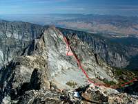
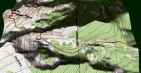
![Highlighted Route up North Trapper]() The Olbu Southeast Face Route. The Olbu Southeast Face Route. | ![3D of Olbu Southeast Face Route]() 3D Topo of the Olbu Southeast Face Route. 3D Topo of the Olbu Southeast Face Route. |
![Profile of Olbu Southeast Face Route]() Profile of the Olbu Southeast Face Route. Profile of the Olbu Southeast Face Route. |


Comments
Post a Comment