
-
 1486 Hits
-
 74.01% Score
-
 4 Votes
|
|
Route |
|---|---|
|
|
46.66714°N / 12.47331°E |
|
|
Download GPX » View Route on Map |
|
|
Hiking, Skiing |
|
|
Spring, Summer, Fall, Winter |
|
|
A long day |
|
|
Hike |
|
|
Overview
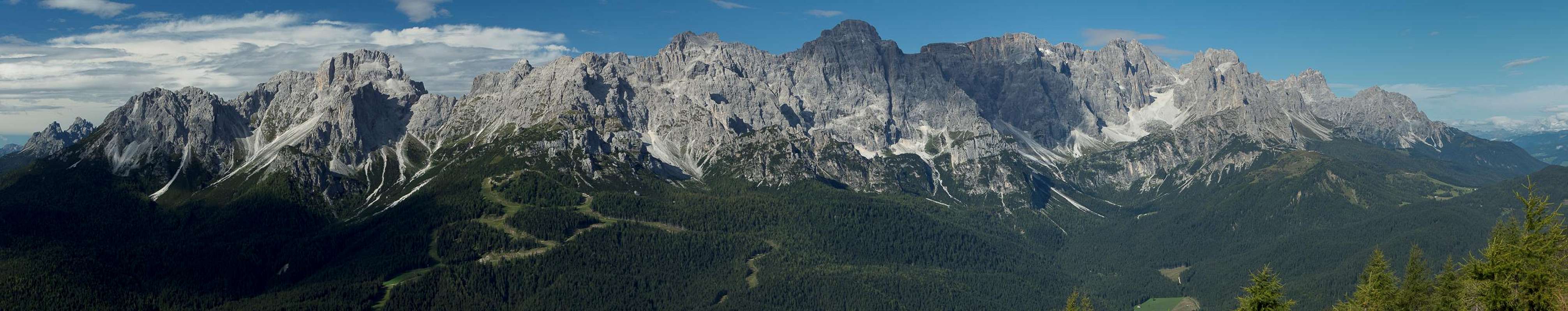
 Costa della Spina seen from Knieberg / Col Quaterna Costa della Spina seen from Knieberg / Col Quaterna |
When it comes to panorammic hiking routes there are few ranges in the Alps better equipped than the Carnic Alps Main Ridge. Almost alll of the terrain is above the timber line and while much of the routes consist of paths along beautifully green meadows the summits are often serious undertakings. The most famous one of them all is the Karnischer Höhenweg / Traversata Carnica Trekking Trail, which runs the whole length of the range for more than 100km along the old trenches and positions of WW I. In addition to good hiking and climbing it thus offers a glimpse into history and a multitude of ever-changing views towards the neighbouring mountain ranges. The westernmost part - thanks to its proximity to the beautiful Sexten / Sesto Dolomites - is the most popular one and on a fine weekend you will hike among crowds of people.
Less known and shorter but nonetheless almost as spectacular is the hike along Costa della Spina, a long whaleback ridge to the south-east of the Carnic Alps Main Ridge, which starts at Casamazzagno Village and culminates in Knieberg / Col Quaterna a pyramid shaped mountain overlooking Kreuzbergpass / Passo di Monte Croce di Comelico. The mountain itself is very popular as it can be climbed from the pass in about two hours but the Costa della Spina Ridge is as solitary as it gets. The only drawback is its popularity among mountain bikers who tend to use it as descent route from Knieberg / Col Quaterna.
The route is never difficult (a few scrambling steps near the summit excepted). It starts as a forest road which soon turns into a path running along the broad backed ridge. Once above the timber line the views towards the Sexten / Sesto Dolomites dominate everything, overshadowing the equally impressive Carnic Alps by much.
Getting There
 San Lorenzo Chapel
For the trailhead at Casamazzagno di Comelico take the following directions:
- From the north-west:
- Take Brenner Motorway E45 to the exit Pustertal / Val Pusteria
- Switch to SS49 to Innichen / San Candido
- Here Switch to SS52 south through Sexten / Sesto across Kreuzbergpass / Passo di Monte Croce di Comelico
- In Casamazzagno look for the Chapel San Leonardo above the village.
- Take Brenner Motorway E45 to the exit Pustertal / Val Pusteria
- From the north-east:
- Take Felbertauernstrasse B108 or Großglockner Hochalpenstrasse B107 to the city of Lienz
- Switch to B100 west which turns into SS49 after you cross the border to Italy
- At Innichen / San Candido switch to SS52 south through Sexten / Sesto to Casamazzagno.
- Take Felbertauernstrasse B108 or Großglockner Hochalpenstrasse B107 to the city of Lienz
- From the south (Beluno):
- Take motorway A27 to its end at Ponte nelle Alpi
- Take SS51 north to Pieve di Cadore
- Switch to SS51b north to Lozzo di Cadore
- Here change to SS52 which takes you all the way to Casamazzagno
- Take motorway A27 to its end at Ponte nelle Alpi
Route Description
  |
- General:
- Start altitude: 1360mm
- Summit altitude: 2502m
- Prevailing exposure: E (on Knieberg / Col Quaterna)
- Type: Hike
- Protection: None
- Start altitude: 1360mm
- Effort: 3 - Elevation gain: 15000m
- Power: 3 – Strenuous
- Psyche: 1 – Easy
- Difficulty: 1 - Easy
- Orientation: 1 – Easy
From the parking space above San Leonardo Chapel head northward across the pastures of Casamazzagno di Comelico. It passes several farmsteads and houses, heading towards a clearing in the forest coming down from Costa della Spina. After the last houses the path turns right into the forest, regains the northerly direction and starts climbing a rutted track. A few switchbacks take you to a clearing (first views towards the Sexten / Sesto Dolomites), then further up until the trees start to thin.
 |  |  |
At first you stay on the Carnic Alps side (east)of the ridge but soon you head up to the first summit, Monte Spina. The path turns to the western side, passing Col Rosson and Colle della Crodata which, however, can be easily bagged. After the latter summit the route from Kreuzbergpass / Passo di Monte Croce di Comelico joins, together with crowds of people.
 Dolomiti Friulane
From the junction a rutted track takes you to the base of the summit pyramid of Knieberg / Col Quaterna. At an old WW I fort the trail splits with the northen branch heading around the summit back down to the pass (another option is to head up to the Carnic Alps Main Ridge proper. Instead take the left hand branch, which now steeply climbs the somewhat exposed east slopes of Knieberg / Col Quaterna. A few switchbacks take you to the top which offers wonderful all around views.
 |
Return the same way.
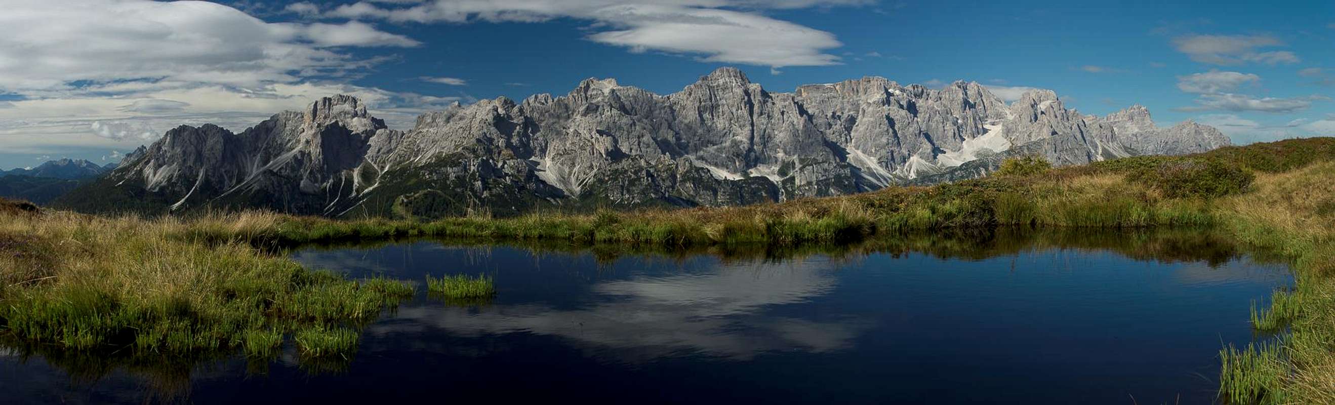
Views from Knieberg / Col Quaterna
 Brentoni Group Brentoni Group | |||
 Monte Aiarnola Monte Aiarnola |  Croda da Campo Croda da Campo |  Cima Padola Cima Padola |  Cima de Ambata Cima de Ambata |
 Cima Bagni Cima Bagni |  Elferkofel Elferkofel |  Sextner Rotwand Sextner Rotwand |  Dreischusterspitze Dreischusterspitze |
 Carnic Alps Carnic Alps | |||