
-
 3882 Hits
-
 75.81% Score
-
 6 Votes
|
|
Mountain/Rock |
|---|---|
|
|
46.66714°N / 12.47331°E |
|
|
Download GPX » View Route on Map |
|
|
Hiking, Skiing |
|
|
Spring, Summer, Fall, Winter |
|
|
8209 ft / 2502 m |
|
|
Overview
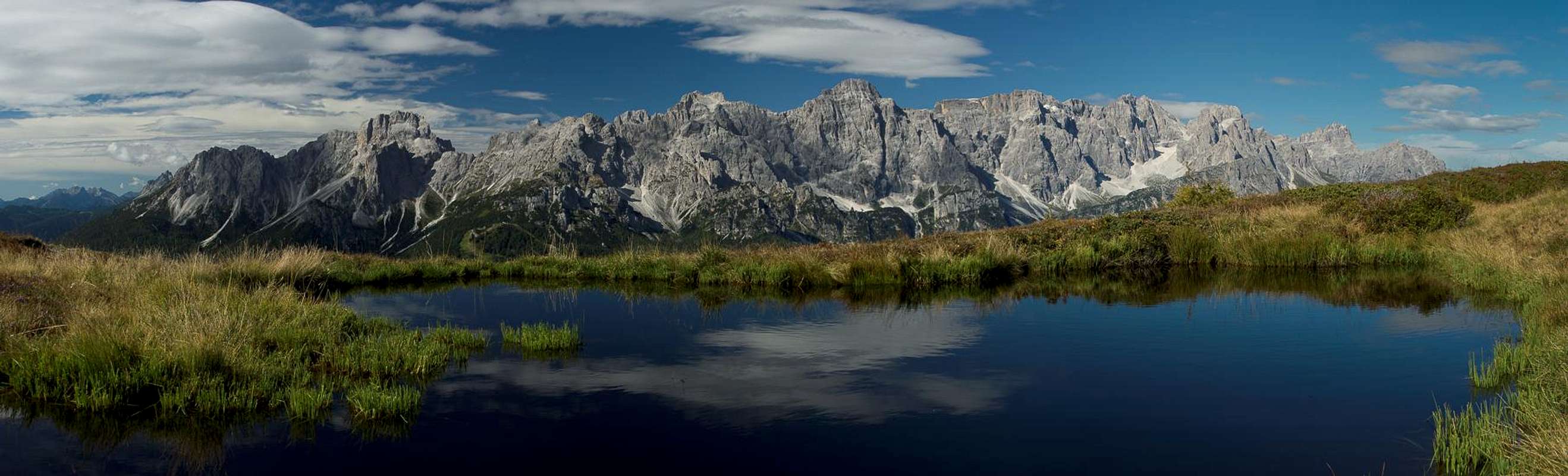
 Knieberg / Col Quaterna seen during the approach along Costa della Spina Knieberg / Col Quaterna seen during the approach along Costa della Spina |
If you want to take an overview of the Sexten / Sesto Dolomites there are few places better suited than the westernmost mountains of the Carnic Alps Main Ridge. They are located just across Sextner Tal / Valle di Sesto and offer deep inights into this very compact Dolomite Group. However, the Carnic Alps Main Ridge gradually draws away from its neighbour increasing the distance between the ranges.
However, to the south, there is a north-to-south running side ridge of four mountains which accompanies the Sexten / Sesto Dolomites almost to its southern end. Costa della Spina is located on the eastern side of Val Comelico and consists of (south to north)
- Monte Spina (1966m)
- Col Rosson (2304m)
- Colle della Crodata (2310m)
- Knieberg / Col Quaterna (2502m).
 From the south From the south |  From Passo Palombino From Passo Palombino |  From the east From the east |
The ridge gradually rises from an unimpressive Monte Spina right above the timber line until it reaches Knieberg / Col Quaterna, which at 2502m rivals the main ridge mountains across Kniebergsattel / Passo Silvella. The mountain rises above the pass for about 200m and it is easily identifiable by its triangular shape. From up close, however, Knieberg / Monte Quaterna reveals an extended south-east ridge, along which the ascent route rises. Far from difficult, it is rather exposed near the summit.
 From Costa della Spina From Costa della Spina |  Porze and Crode dei Longerin Porze and Crode dei Longerin |  From Porze From Porze |
In WW I Kreuzbergpass / Passo di Monte Croce di Comelico was one of the main theatres of the Dolomite Front and even the first shots were fired there. However, the front didn't move so that three years later the war ended with basically the same positions that it started with. In the meantime many of the mountains around the pass had been fortified. The most important positions were at Sextner Rotwand / Croda Rossa di Sesto and along the Carnic Alps Main Ridge but the proximity to the pass ensured that there were many positions all around and up to Knieberg / Monte Quaterna. Today you can see the remnants of a fort to the north-west of the mountain as well as advanced position and trenches at its eastern base, which head up right to the summit. Obviously the mountain was what it remains today: an important lookout.
There is the long line of the eastern Sexten /Sesto Dolomites right across the valley in the west as well as the Brentoni Subgroup of the Southern Carnic Alps in the south. To the east the highest mountains of the western Carnic Alps Main Ridge rise up right close, notably Pfannspitze / Cima Vanscuro, both Kinigats / Monte Cavallino and Cavallatto and Porze / Cima Palombino. To the east and a bit hidden Hohe Warte / Monte Coglians and Hochweißstein / Monte Peralba can be seen.
Views from the Summit
 Sexten / Sesto Dolomites Sexten / Sesto Dolomites | |||
 Monte Aiarnola Monte Aiarnola |  Croda da Campo Croda da Campo |  Cima Padola Cima Padola |  Cima de Ambata Cima de Ambata |
 Cima Bagni Cima Bagni |  Elferkofel Elferkofel |  Sextner Rotwand Sextner Rotwand |  Dreischusterspitze Dreischusterspitze |
 Carnic Alps Carnic Alps | |||
Getting There
There are two reasonable trailheads for Knieberg / Col Quaterna, one at Kreuzbergpass / Passo di Monte Croce di Comelico and one at Casamazzagno di Comelico. Both can be reached from SS52 which connects Südtirol / Alto Adige with Veneto and Friuli.- From the north-west:
- Take Brenner Motorway E45 to the exit Pustertal / Val Pusteria
- Switch to SS49 to Innichen / San Candido
- Here Switch to SS52 south through Sexten / Sesto to the trailheads. The one at Casamazzagno is a bit above the village near the Chapel San Leonardo
- Take Brenner Motorway E45 to the exit Pustertal / Val Pusteria
- From the north-east:
- Take Felbertauernstrasse B108 or Großglockner Hochalpenstrasse B107 to the city of Lienz
- Switch to B100 west which turns into SS49 after you cross the border to Italy
- At Innichen / San Candido switch to SS52 south through Sexten / Sesto to the trailheads.
- Take Felbertauernstrasse B108 or Großglockner Hochalpenstrasse B107 to the city of Lienz
- From the south (Beluno):
- Take motorway A27 to its end at Ponte nelle Alpi
- Take SS51 north to Pieve di Cadore
- Switch to SS51b north to Lozzo di Cadore
- Here change to SS52 which takes you all the way to Casamazzagno and Kreuzbergpass / Passo di Monte Croce di Comelico
- Take motorway A27 to its end at Ponte nelle Alpi
Routes
  |
- The route from Kreuzbergpass / Passo di Monte Croce di Comelico is the shorter one of the two and follows dirt roads for much of the way. Like the route across Costa della Spina it is popular with mountain bikers, which generally use it to bike up the mountain. At an intersection above Casa di Rinfreddo a WW I supply road turns off left and leads to an old military position at the south-eastern base of the mountain, where the Costa della Spina Route joins. The remainder is an easy if somewhat exposed hike along the south-eastslopes of Knieberg / Col Quaterna
- The route from Casamazzagno in the south follows the ridgeline of Costa della Spina, a secondary side ridge of the Carnic Alps Main Ridge. The ridge is broad but already above the timberline so that it affords wonderfoul views all the way from Monte Spina (1966m) in the south to Knieberg / Col Quaterna. While it avoids further summits, you will be able to bag Col Rosson (2304m) and Colle della Crodata (2310m) without too much effort. The route is long (11km one way) and covers a lot of elevation (almost 1500m). In addition, it is used as fast descent route by mountain bikers so that it can get rather dangerous.
Red Tape
There's a bit of red tape on Kreuzbergpass / Passo di Monte Croce di Comelico: you're not allowed to park your car in the lot near the hotel on top of the pass but there is a big parking lot on either side of the road a bit to the north. Also, you will be close to the Austrian / Italian border, whatever this means in times of open borders. Bringing an ID is certainly a good idea anyway.When to Climb
Basically Knieberg / Col Quaterna can be climbed all year round. In winter a ski tour from Casamazzagno should be possible without avalanche danger and only the final 150m might be a problem. The slopes from Kreuzbergpass / Passo di Monte Croce di Comelico are steeper and thus might pose more dangers. However, the south-western direction of the slopes ensures that the snow melts early in the year.Accommodation
Hotels and Apartments:Camping:
External Links
Maps & Books
Books
- Dolomiten 5 - Sexten - Toblach - Prags
F. Hauleitner
Rother Verlag
ISBN: 3 7633 4199 4
Maps
The most commonly used maps are the ones by Kompass and by Tabacco. The Kompass one is good as an overview map while the Tabacco one offers more details.
- Sextner Dolomiten / Dolomiti di Sesto
Kompass Map WK 58
ISBN: 3 87051-065-X
Scale: 1:50000
- Sextner Dolomiten / Dolomiti di Sesto
Tabacco Map 010
Scale: 1:25000