
|
|
Route |
|---|---|
|
|
19.26504°N / 97.44733°W |
|
|
Hiking |
|
|
Half a day |
|
|
Easy |
|
|
Overview
Derrumbada Roja is the bigger of the two domes belonging to the Derrumbada massif. Its official altitude is 3480 m a.s.l., although my GPS has consistently had higher measurements, closer to 3490 m, in each of my three ascents. (Note: This is because the official topographic maps of INEGI —the Mexican agency for statistical and geographical information— have contour lines in 20 m sequence, so any given location in Mexico has an elevation margin of error of up to +19 meters.)It is nonetheless more easily accessible than its twin. The path described below is pretty clear and doesn't involve any scrambling or bush-whacking. Following the instructions, you'll complete the ascent in around 3 hours and be back down after max. 7 hours.
The diversity of ecosystems you have to traverse from the bottom to the top have made this route one of my very favorite in the region. Also, it is by no means a comfortable picnic stroll, so at the end you'll really have the feeling that you achieved something — without any special equipment or having to expose yourself to large crowds. :)
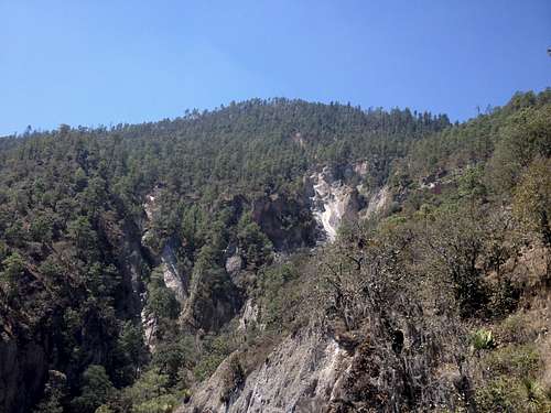
Derrumbada Roja forest and gullies from the northeastern trail.
Getting There
Take the road that connects San Luis Atexcac and Guadalupe Victoria, then turn south-southwest (right if coming from Atexcac) at 19°18'28"N 97°23'54"W. Follow this gravel road uphill, past a mine and some fields. The exact location of the trail head is 19°17'13"N 97°25'56"W. There is enough room beside the road to leave your car. The road continues to a mine, but you'll cross the fence on your left and take an abandoned road uphill.
Fumaroles near the Derrumbada Roja summit.
Route Description
The first 600 m are on this abandoned road, until it makes a right turn and sort of vanishes. After a few meters, turn left on the dry riverbed. This riverbed will soon lead into a bigger gully. Pay attention to the path here, as you will soon need to get out of the gully (aproximately after 1.8 km total). Conveniently, some hikers have marked the path with pink ribbons on tree branches.
For the next kilometer, you'll take an arrête between two deep gullies. As I said on the main page, don't stand too close to the cliffs, as you might risk a fall. There is a pretty rocky part at the end of this section, so take appropriate safety measures, especially on you way down.
The next section is a mostly flat and beautiful pine forest which is suitable for camping or for a pause. Cross the little stream on your left and go around the hill before you clockwise. Next you will see a deep, deep gully on your left. The summit is on the other side, so you have to get to the head of the gully. Keep hiking uphill and turn left at aprox. 3080 m a.s.l.
Now you're in a dense fir forest, richer in shrubs and herbs than the previous pine forest. Follow the trail and descend into the narrow, stony gully. Here's a tricky part: Pay attention to the pink ribbons mentioned before! You'll have to get out of the gully after less than 100 meters, taking a path on your left side. Climb uphill and out of the steep fir forest, where an alpine shrubland takes you to the summit.
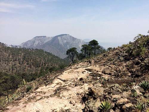
There's a neat geological feature at around 3390 m: a geothermal field with plenty of fumaroles. It stands out as a desolated area with little vegetation and porous, steaming soil.
Continue through the high grasses to the summit. On a clear day, you'll have a magical view of Pico de Orizaba.
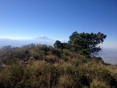
Derrumbada Roja summit, with Pico de Orizaba in the background.
Essential Gear
You really don't need anything out of this world. Bring high-cut hiking boots, a wind jacket, along with sufficient snacks (apples, nuts, a sandwich) and water (1.5 l), as well as sunscreen and sunglasses.