
|
|
Route |
|---|---|
|
|
39.97800°N / 105.684°W |
|
|
Trad |
|
|
A long day |
|
|
5.6 |
|
|
Approach
Drive to the north end of Fraser on Highway 40, and to between mile markers 226 and 227. Turn east on to the road marked for County Road 8. Follow County Road 8 for 6.4 miles to the forest service boundary, at which point the road becomes Forest Road 128. Turn left and follow the road for 1.1 miles to a junction at which point you will turn right and drive for .3 miles to the end of the road and at a small dam. This is the trailhead. This road is also rough in places, but can be driven by a car if you go slowly and if care is taken. |
Route Description
Route Devils Thumb Park/Cabin Creek to Devils Thumb PassThis route has more elevation gain than the route from Rollins Pass, but is about the same distance. This route offers the advantages of a few campsites along the way, and is less exposed to the elements. From the trailhead at 9640 feet, follow the trail east. After about .75 miles there is a junction. Turn right on the trail marked for Devils Thumb. There is a stream crossing on a bridge across Cabin Creek, and up until here, the trail ascends at a very gentle grade. The trail is faded (2003) at first as it crosses the meadows of Devils Thumb Park, but after crossing the meadows, it become distinct and easy to follow. The trail climbs along Cabin Creek while passing some waterfalls. The trail becomes steep and climbs to timberline. There are some small campsites located in a meadow near timberline. The views open up and the trail climbs to Devils Thumb Pass (11,747 feet elevation) after 3.4 miles. Enjoy the fine views in all directions from the pass. Note that the topo map does not show the trail correctly. The trail actually follows the north side of Devils Thumb Park and stays well north of where it is marked on the map until the creek crossing. The trail then stays a bit south of where it is marked on the map for the entire way to the pass.
Technical Route up Devils Thumb: Devils Spiral-Direct Route to Notch Variation
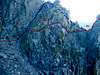
From Devils Thumb Pass, head north along the ridge up a steep trail. Follow the trail to a cairn which is located to the west and just above the level of the notch between Devils Thumb and the main ridgeline.
Scramble down a grassy chute and then traverse a loose rubble covered slope to the area just west of and at the same elevation as the notch. You will notice a ledge that heads east towards the notch. You will also notice a grassy chute ascending north and up to a ridge. This grassy chute is the route described in Roach’s book, but we chose a more direct and more exciting route to the notch.
Next, follow the exposed ledge east to where it ends. Continue traversing east along the wall. You will notice an old piton pounded into the wall at the beginning of the traverse. There are several other places along the traverse where you can place protection. After traversing horizontally, you will downclimb a wall to another ledge and traverse. The downclimb (20’) is 5.6 in difficulty. Continue traversing directly to the notch which will be in view after the downclimb. There are several places to place protection if you search for them.
From the notch, angle up the left side of the tower to the east by following a steeply rising and sloping ramp. An old piton marks the beginning of the route. Spiral around and up the tower to the east side.
You will now climb up the tower as the exposure increases dramatically. Contour around to the left and up to the final summit block located on the south face. There are several moves of 5.2-5.3 along the way, and several more difficult variations are available by altering the route slightly. There are several places to place protection, so please leave the bolt kit and nailing equipment at home. The summit is incredible. There is enough room on top for a few climbers to sit down and enjoy the spectacular views and exposure. The highest summit block actually moves, so don’t stand on it!
Devils Thumb Lake is located directly below and 1000 feet down. There are great views of the peaks in all directions, including a nice view to the north and to a spectacular vertical alpine wall. If the weather is clear, plan on spending some time to kick back and enjoy the exposed views. If the weather is bad, or if there is a chance of it becoming bad, don’t even think of climbing the tower as it is a virtual lightning rod!
Descent Route
Note: Roach’s book says that a secure anchor can be difficult to find to rap off for the descent, but this is certainly not the case. There are several bomber anchors in the summit area. From the summit, the easiest descent route is to do a two-pitch rappel back to the notch. When tossing the rope off the summit, it appears that it will be very tricky to rappel and land on the notch, but this is not really the case. Rap off the summit from a block located on the “notch side” of the summit. Not far below the summit, there is a chockstone which can be used to set up the second rappel down to the notch. By using this chockstone, the rap can be done is two stages using one 60-meter rope (a 50 meter rope will be just short, but you can use two 50 meter ropes if you don’t have a 60). If you have two 60 meter ropes, you can rap to the notch from the summit block, but it is probably better just to take one rope and do the rap in two stages. Note that the rope can be very difficult to pull from below from either the chockstone or the summit block, so make sure to set the rap stations as carefully as possible.
The total round trip distance is about 8 miles with 2750 feet elevation gain. With the technical climbing, plan on a long day. Make sure to get a very early start to avoid afternoon thunderstorms.


 |  |