
-
 25949 Hits
-
 90.13% Score
-
 31 Votes
|
|
Mountain/Rock |
|---|---|
|
|
37.59575°N / 119.0133°W |
|
|
Trad Climbing, Sport Climbing, Toprope |
|
|
Spring, Summer, Fall |
|
|
9400 ft / 2865 m |
|
|
Overview

Dike Wall is a rock formation in the Mammoth Lakes area of the Eastern Sierras.
When we speak about the town of Mammoth Lakes and Mammoth Mountain, the first thing that comes to our minds is skiing. Mammoth Mountain is, in fact, a dormant/semi-active volcano and for decades it has been the destination of choice for southern California skiers. During the summer months, Mammoth Lakes turns into one of the most desirable resorts for mountain biking, fishing, hiking and rock climbing. The town itself is at an elevation of 7500 feet and the nearby lakes and mountains stay pleasant during the hot summer season. Forget trying to get up before dawn to get a couple of hours of climbing around Owens Valley before temperatures soar to over 100 degrees. Go to Mammoth Lakes and climb on Dike Wall at an elevation of 9400 feet.
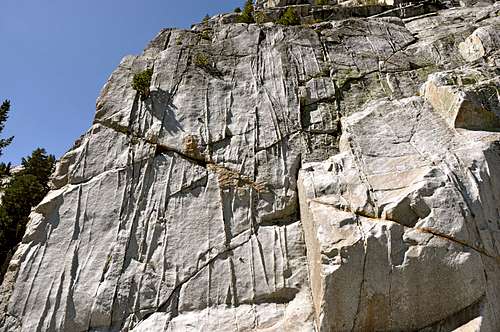
Dike Wall is an extensive rock formation high up on the mountains surrounding the town of Mammoth Lakes. The north face of Dike Wall is several hundred feet long and most of the length stays in the shade all day long. In fact, I have never seen the base without snow even in the middle of summer, dirt-covered as it may be. On my first visit to the north face of Dike Wall I had to kick step in hard snow, in climbing shoes nonetheless, to get to the rock. You can’t find too many climbing formations as good as Dike Wall’s north face for the warm weather season.
 |
 |
 |
 |
|---|
Climbs of the north face
Left side of the north face
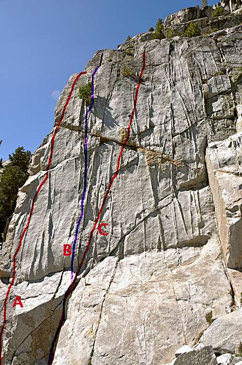
Even though Mammoth Mountain is a volcano, many of the rock formations in its vicinity are granite. One may argue that granite is also vocanic, although it is of a different chemistry that makes it by far more solid. The history of climbing on Dike Wall dates back to the 1980s when most of the routes were top-roped. During the 1990s and early 2000s many of the old routes were bolted into sport climbs. The access to the top for the left side of the north face is achieved via a fun 5.8 crack named “Mr. DNA.” Mr. DNA is a fun gear-protected hand crack with a small tree growing out of it near the top. You can easily set up top rope for a 10a face to the right of the crack, or a 10b shoulder to its left. The right hand face, “Mr. Kamikaze, 10a” and the left shoulder “Mongoloid, 10b” are both bolted now and can be done on lead or top rope.

The true north face
The sport routes of the right side, or true north face, of Dike Wall are not as moderate as the far left ones. Except for one 10c route called “Double Ender,” the rest are all in the 5.11 to 5.12 range. There is a crack/corner on the far right side of the north face called “Solo route, 5.7” that provides access to the top. I have not been fortunate enough to see anyone leading any of the harder routes on the north face. Most of the routes of the north face have their own anchors that can be used for lowering off.

John Bachar, a climbing icon was killed soloing this rock in July of 2009.
A personal note:
John Bachar’s reputation proceeded him wherever he went. The first time I saw him was at Owens Gorge where he quickly soloed “Hard Copy, 12a”, a climb that I top-roped with a great deal of difficulty and “Hangdogging.” Peter Croft, another legendary climber, who accompanied John Bachar on the first two grade six walls in Yosemite in one day, gave a slide show in Santa Barbara. Someone in the audience asked Peter how they were able to pass so many climbers on two big walls. Peter answered, “If John was in front, everybody cleared the way for us, and if I was in front all I had to tell them was that ‘John Bachar is coming up.’”
John Bachar was a legend and an icon. The climbing community will miss him for a long time.
 |
 |
 |
 |
 |
Dike Wall, north face |
|
| A | Mongoloid, 10b, bolts |
| B | Mr. DNA, 5.8, crack, standard rack, bolt anchor |
| C | Mr. Kamikaze, 10a, it has been bolted into a sport route |
| D | Quick Lick, 11a, bolts |
| E | Dichotomy, 11b, bolts |
| F | Strap-On-Tools, 12a, bolts |
| G | Black Leather, 11a, bolts |
| H | Box Lunch, 11d, bolts |
Camping
There are many campgrounds in the town of Mammoth Lakes. During the summer months, these campgrounds always seem to be full to the brim. I personally prefer to look for camping possiblities ouside of the town boundries. There are many other campgrounds on the way to Mammoth Lakes that can be used. There is another option; during the summer months motel rates drop dramatically making them a desirable way to spend a few nights in luxury. Needless to mention, amenities abound.
The folowing link should help finding accomodations.
http://www.tripadvisor.com/Attraction_Review-g60791-d1119984-Reviews-Mammoth_Lakes_Visitor_s_Center-Mammoth_Lakes_California.html
you may ask about Lake George campground and Lake Mary campground,
Or,
you may want to try the following links for camping outside of the town of Mammoth Lakes:
Horton Creek Campground
Rock Creek Canyon
Inyo National Forest
Bishop Creek and vicinity camping
How to get there
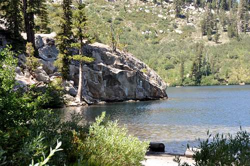
Rocky outcrop at the far end of Lake George

Cabin 6
From the town of Bishop, California, drive forty miles north on Highway 395 to its intersection with Highway 203, Mammoth Lakes, Devil’s Postpile. Take this exit and drive into the town of Mammoth Lakes. Drive through the town staying on HWY 203 to a 4-way traffic signal where HWY 203 turns right. At this point go straight on Lake Mary Road. Drive 3.7 miles to Pokonobe Lodge Rd and turn left. Continue down Pokonobe Lodge Rd for about 1/4 mile to a T in the road. Turn right at the T, and drive a short distance to the Lake George parking lot.
From here walk clockwise along the shore of Lake George past the sign for TJ Lake and several cabins. Close to opposite end of the lake from the parking lot, you will see a rocky outcrop protruding into the lake. Just before the rocky outcrop head up the hill and find cabin 5 and cabin 6. There is a beautiful trail that starts behind cabins 5 and 6. This is your trail. Follow the trail to a short boulder field and Dike Wall.
Note: If you hike up to the top of the rocky outcrop and see the trail going downhill, you have gone too far.
External Links
Add External Links text here.