-
 10388 Hits
-
 85.87% Score
-
 21 Votes
|
|
Mountain/Rock |
|---|---|
|
|
37.60562°N / 119.02082°W |
|
|
Mono |
|
|
Trad Climbing, Sport Climbing, Toprope |
|
|
8900 ft / 2713 m |
|
|
Overview

Horseshoe Slabs are two neighboring rock formations in the Mammoth Lakes area of the Eastern Sierras in California.
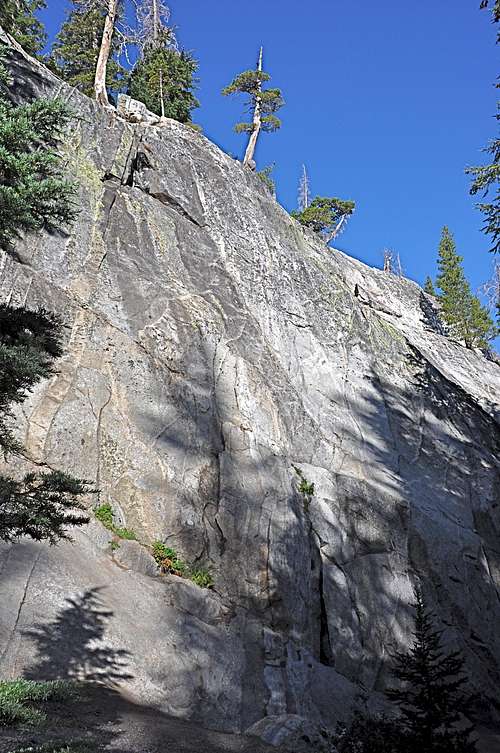
 left slab
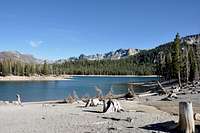
As indicated by their name, these two formations are low angle and joined by a rocky gully. These two granite slabs are between sixty and eighty feet in height and several hundred feet long. The approach trail takes you past Horseshoe Lake, with one of its shores completely void of living plants.Volcanic fumes seeping up into the lake itself and the surrounding areas have created a toxic wasteland. Regardless of this geologic phenomenon, there is a very popular trail just beyond the devastated area that gets heavily used by runners, hikers, climbers and sled dogs in training. I have gone through the area a number of times and have never sensed any odors from volcanic chemicals. But the landscape alone speaks volumes as to the hidden forces at play here.
 right slab
The combination of a ten minute approach and two low angle formations are enough to make Horseshoe Slabs a very popular spot for families. You often see young, and not so young, parents teaching their kids the ABCs of rock climbing on these two rocks. Horseshoe Slabs are more like a picnic area than a rock climbing one. If the kids aren’t struggling up the rock, they may be building structures using dead tree branches. Generally speaking, Horseshoe Slabs area is a fun place to spend a few hours.


Routes of Horseshoe Slabs
 Left Slab
For many years Horseshoe Slabs have been an area where you bring your family or friends to top rope climbs. During the past several years, however, several of the routes were bolts into sport routes, and some even have names. The days of designating only numbers to the routes are slowly disappearing. I have also noticed that a number of climbs on the left formation have bolted anchors. I feel that this new development has made Horseshoe Slabs a safer rock to play on. The old trees that were used for anchors were either dead or about to die. To set up anchors on the left formation, which is the steeper and more difficult of the two, you need to take several long slings to help get close to the edge to use the bolt anchors. Put yourself on belay and be safe.
 Right Slab
The right formation is much lower angle than the left one thus contains easier climbs. The left crack on the right slab is called “Rodeo Rider” rated at 5.6, and it’s a great beginner route. This climb can be done on lead with a standard rack and even has its own bolted anchor.
It is possible that, in time, all the routes on the two Horseshoe Slabs will get their own three point bolted anchors; however, at the present time most climbers use the trees on top as anchors. The approach to the top is done via the right side.
Climbs of Horseshoe Slabs | |
| A | Top Rope, 5.8 |
| B | Top rope, 5.7, follow the left wide black streak |
| C | Wrangler, 5.8, bolts and gear, standard Rack. Follow the right black streak. |
| D | Horseman, 10a, bolts to a good anchor |
| E | Slab, 5.9, top rope to a good anchor. Many possible variations. |
| F | Top rope a slab, 5.7 |
| G | Cow Puncher, 5.6, left prominent crack, standard rack |
| H | top rope a slab, 5.7 |
| I | Rodeo Rider, 5.6, right prominent crack, standard rack |
| J | Top Rope, 5.9, slab |
| K | Blacksmith, 5.8, bolt and gear, standard rack |
 |  |  |  |  |
Camping
There are many campgrounds in the town of Mammoth Lakes. During the summer months, these campgrounds always seem to be full to the brim. I personally prefer to look for camping possiblities ouside of the town boundries. There are many other campgrounds on the way to Mammoth Lakes that can be used. There is another option; during the summer months motel rates drop dramatically making them a desirable way to spend a few nights in luxury. Needless to mention, amenities abound.The folowing link should help finding accomodations.
http://www.tripadvisor.com/Attraction_Review-g60791-d1119984-Reviews-Mammoth_Lakes_Visitor_s_Center-Mammoth_Lakes_California.html
you ask about Lake George campground and Lake Mary campground,
Or,
you may want to try the following links for camping outside of the town of Mammoth Lakes:
Horton Creek Campground
Rock Creek Canyon
Inyo National Forest
Bishop Creek and vicinity camping
How to get there